
What are different types of maps and how are they used? - PowerPoint PPT Presentation
Title:
What are different types of maps and how are they used?
Description:
EQ: How does one distinguish between the different types of maps? 7.3.spi.14. Distinguish between types of maps. (i.e., political, physical, climatic, land-use ... – PowerPoint PPT presentation
Number of Views:268
Avg rating:3.0/5.0
Title: What are different types of maps and how are they used?
1
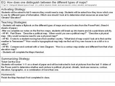
EQ How does one distinguish between the different types of maps? 7.3.spi.14. Distinguish between types of maps. (i.e., political, physical, climatic, land-use resource, contour, elevation, and topographic).
Activating Strategy Students will be asked to list 5 reasons they would need a map. Students will be asked how they know which one to use for different types of information. Which one should I look at to determine what resources an area has? Climate? Elevation?
Teaching Strategies - Students will make a flipbook on the different types of maps and record notes from the PowerPoint. (Need 4 sheets of paper.) After we complete our notes on the first two maps, students will break up into teams and do a pair/share activity. - AP 1 Pair/Share Describe a political map. When would you use a political map?" Describe a physical map. Why would someone need to use a physical map?" AP 2 A note to a student moving here from another country "What kind of map would I look at to find out the weather in Tennessee?" "How would a topographical map help me find out if my new house is on a hill or in a valley? AP 3 Compare and contrast with a Venn Diagram How is a contour map similar and different from that of an elevation map? - Students will complete the Maps Handout.
Summarizing Strategy Ticket Out the Door Students will number 1-11 on a sheet of paper and will be instructed to look at pictures from the last 11 slides of the Power point to determine whether each picture is political, physical, climatic, land-use resource, contour, elevation, topographic, or a combination of more than one.
Homework Finish the Map Handout if not completed in class.
2
Why do you use maps?
- Think of 5 reasons that you would need a map (so
I know where I am going is not an answer I want
you to have on your list.)
3
How do you distinguish between different types of
maps?
SS. Standard 7.3.spi.14. Distinguish between
types of maps. (i.e., political, physical,
climatic, land-use resource, contour, elevation,
and topographic).
4
Political Maps
- Usually colored by country or by state
- Political colors make it easy to compare size,
shape, and location - Bold letters often make the country names stand
out - Symbols make it easy to tell capitals from other
cities - Political maps also name certain physical
features, such as rivers and lakes
5
World Political Map
6
Physical Map
- Has colors that make natural patterns stand out
- The colors on the map can stand for types of
vegetation, mountain, and natural features - Names of big natural features are easy to see
- Physical maps also include some political
information, such as boundaries
7
World Physical Map
8
Pair/Share
- 1s tell 2s
- Describe a political map.
- When would you use a political map?
- 2s tell 1s
- Describe a physical map.
- Why would someone need to use a physical map?
9
Climate Map
- The climate of a place is the weather it has
season by season, year after year - Rainfall and temperature are climates main
ingredients - Climate is affected by elevation, distance from
the ocean, and latitude
10
World Climate Map
11
Land Use Resource Map
- These maps show how land is being used. This
might refer to - vegetation
- crops being grown
- forest vs. Agriculture
- mines and wells
- city zoning
12
(No Transcript)
13
(No Transcript)
14
(No Transcript)
15
Topographic Map
- These maps generally represent a small area with
a lot of detail. They show elevation with
contour lines, natural and man-made features.
16
Topographic Map
17
A new student is moving to Tennessee and is
curious about a few things. Please write him a
one paragraph letter answering his questions.
- How would a topographical map help me find out if
my new house is on a hill or in a valley?
- What kind of map would I look at to find out the
weather in Tennessee?
18
Contour maps
Contour lines represent the elevation at that
line. If you were to walk across a line, you
are changing elevation.
19
Contour map
20
Elevation Maps
- Maps that show elevation change by using color
or shading.
21
Elevation Map
- What is the average elevation of most of our
state?
22
Elevation Map of Tennessee
23
Elevation Map
24
Elevation Map
25
How is a contour map similar and different from
that of an elevation map?
Contour map Elevation map
26
Ticket out the DoorPlease number 1-11
27
1
28
2
29
3
30
4
31
5
32
6
33
7
34
8
35
9
36
10
37
11
38
- 1. Elevation and/or Physical
- 2. Political
- 3. Physical
- 4. Elevation and/or Physical
- 5. Climatic
- 6. Topographical
- 7. Contour
- 8. Political
- 9. Elevation and/or Physical
- 10. Contour
- 11. Land-use resource map
Recommended
CrystalGraphics Presentations


