
Rogers - PowerPoint PPT Presentation
1 / 43
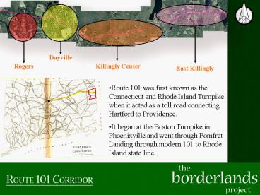
Title: Rogers
1
Dayville
Rogers
Killingly Center
East Killingly
- Route 101 was first known as the Connecticut and
Rhode Island Turnpike when it acted as a toll
road connecting Hartford to Providence. - It began at the Boston Turnpike in Phoenixville
and went through Pomfret Landing through
modern 101 to Rhode Island state line.
2
1825
In 1826 Caleb Williams bought 27 acres and built
a factory based village called Williamsville
1830
Financial troubles in the 1830s forced Williams
to sell the mill to the Atwood family of Rhode
Island.
1835
1840
1855
New brick mills were constructed in the 1860s
along with a school and a church.
1860
1865
1905
3
1910
In 1913, Atwood sold the mill to the Goodyear
Tire and Rubber Company.
1915
From 1917-1919 Goodyear Heights was constructed
1920
1925
Original Mill Plan
1930
The Great Depression forced Goodyear to close the
mill in 1932
In 1935 the Rogers Corp. purchased the mill and
renamed the village Rogers.
1935
1940
Today Rogers provides evidence of industrial
development in Northeastern Connecticut and
continues to symbolize the textile industry.
Tennant Houses
2008
4
1955
1869
2008
Additions to the Mill and new tenant houses built
to the southeast of the Mill. Goodyear Heights
built in 1919 to the East of the Mill
Additions to the Mill and demolitions of tenant
houses along road
Original Map of Williamsville Mill
5
(No Transcript)
6
- Assets of Rogers Village
- Proximity to Alexander Lake.
- Quinebaug River access.
- Historic Buildings Goodyear school, Rogers
Mill, Post Office, and Church. - Residential Village itself continues to maintain
its historic vitality and character. - Still maintains a large amount of forested and
undeveloped land.
7
- Alexander Lake
- Lake named after William Alexander, who built
the first mill in Dayville. - The lake was once used as a reservoir for
Williamsville. - In 1903 Wildwood Park was developed along the
lake. A Trolley provided access to the lake and
the pavilion that was built for public enjoyment.
Fireworks, picnics, and shows were an attraction
to the park. - Today, public access to the lake no longer
exists, and it remains a private use lake.
8
1955 USGS Map
Present Day Aerial
9
- Future of Rogers Village
- Maintain historic vitality of Rogers.
- Provide access to open space, and water
resources. - Preserve key areas of forested land within Rogers
while allowing for future growth of the village. - Establish a connection to Alexander Lake if made
a public use. - Create a presence of Rogers on the 101 Corridor.
- Provide open space, and opportunities for mixed
use development around existing Rogers Mill site.
10
DAYVILLE VILLAGE Historic Timeline
- Prior to 1830
- Dayville did not exist as an identifiable
identity - Only an area of farms and woodlands
- Distinguished by 2 features
- Five Mile River
- Alexander Lake
- Wealthier farmers began to establish small water
power sites along the river and outlet of the
lake - Prosper and William Alexander, Samuel and John
Bassett, Abel B.Williams, and Captain John Day
Historic Timeline
11
- 1832
- Day, Bassetts, and Alexanders develop sites
along Five Mile River - Include cotton mill, dam and series of storage
ponds - Canal built, diverting Five Mile River into Lake
- Became source of nearly unlimited pondage for
mills
Historic Timeline
12
- 1835
- Construction of Norwich and Worcester Railroad
through center of the settlement - Dayville becomes freight terminus for other
manufacturing sites along the Five Mile River and
Whetstone Brook - Dayville becomes a commercial center for
surrounding villages - Stores, feed lumber business, large hotel,
stables, and increase in housing
Historic Timeline
13
- 1849
- Separate Dayville Congregational Church is
organized
- 1855
- Hotel built by Horace Woodard
Historic Timeline
14
- 1858
- Sabin Harris Sayles bought Days Mill
- Convert to manufacture of woolens
- Increase in housing to accommodate larger work
force
- 1882
- Sayles built a large new brick building
Historic Timeline
15
Historic Timeline
16
- 1893
- Sayles company went under
- Mill sold to Norwich-based partnership
- Dayville Woolen Co.
- 1903
- Dayville Woolen Co fails
- Sold to Assawaugan Co.
- Many new houses
- Weave room added to mill
- 1939
- Mill bought by William Prym
- Wire manufacturer
Pryms Mill
Historic Timeline
17
- 1955
- Interstate Highway 395 is constructed
- 1974
- Killinglys Industrial Development Corporation
purchased land for the present industrial park
- 1980s
- Growth of businesses near the transportation hub
Historic Timeline
18
(No Transcript)
19
(No Transcript)
20
(No Transcript)
21
(No Transcript)
22
(No Transcript)
23
(No Transcript)
24
(No Transcript)
25
Killingly Center was once the heart of Killingly
with the busy route of 101 passing directly
through it. It once housed the Killingly town
meeting hall at the corner of Cook Hill Road and
Route 101. The first town meeting was held there
on December 12, 1785. The hall continued to be
used until 1906 when it moved to the Music Hall
in Danielson.
26
1934 (Route 101 Highlighted)
27
1964 (Route 101 Highlighted)
28
Current (Route 101 Highlighted)
29
Current Road map overlaid with 1869 boundary of
Killingly Centre
- -Deforested land shown in green
- Trend of reforestation, parallel with overall New
England history
30
Transportation Development
- Railroad constructed in 1840 redirected
development from Killingly Center to Dayville and
Rogers
- Purple lines represent roadway network in 1934
31
Transportation Development
- Since highway construction, large shopping plazas
have cropped up around transportation hub
32
(No Transcript)
33
The Town Hall is no longer on the Hartford
Turnpike in Killingly Center.
Mills attract more people for labor
opportunities. In Killingly Center the Whetstone
brook ran mills which pulled labor away from
agriculture and into manufacturing wool.
This transition to manufacturing led to the
reforestation of the area.
34
With the reforestation of the area and the mills
going out of service Killingly Center is mostly
comprised of single family housing with
continuing development.
35
Many Mills developed along the Whetstone Brook
during the 1800s.
36
The Sayles Mill was one such mill built in 1846
by John Day, a wealthy farmer with interests in
real estate. He leased it to the manufacturing
firm of Asher Starkweather. The original
building does not exist any longer.
After rebuilding the mill in 1882, Sabin and
Harris Sayles built numerous mill houses for use
by their larger work force. The character of
this type of mill housing can be seen in
Killingly Center along 101 to this day.
37
Typical House lot today
Typical Mill Housing of the 1800s
Road
Today houses are set back from the road and
spread out from each other with current set back
and zoning laws. It is alienating and uses far
more resources than more creative alternatives.
This model can also be seen with business
development today.
As a model for new development the idea of
clustering homes reduces resources, encourages a
neighborhood feel. It is a model being used in
other new developments around the country today.
This model could also be used for developing
commercial with parking behind.
38
Today Killingly Center is mostly residential with
some farms and businesses and it should be
developed retaining these features and developing
them further. The remnants of the mills along
the Whetstone Brook is a major asset to the town.
39
Historic Map Of Killingly -1869-
40
Chestnut Hill District/ East Killingly
village shows no physical sign of the old
boundaries which used to be. Present day
property lines spill into adjacent historic
districts. The boundaries have become blurred.
Estimated surface area of the old Chestnut Hill
outline is approximately 4.8 sq. mi. or 3,072
acres.
41
Hartford Pike / Route 101
42
Present Day Aerial
Hartford Pike / Route 101
- Killingly Facts
- Incorporated 1708
- Population 16,472
- -2000 Census
- The Town as a total area of 50.0 square miles
- 1. 5 square miles (2.94) is water
- United States Census Bureau
43
Historic To Present Change
Farm Land to Forest Farm Land to Residential