
Illinois Natural History - PowerPoint PPT Presentation
Title:
Illinois Natural History
Description:
One key to the rich biodiversity of present-day Illinois lies in its varied geologic past. ... Geology continued...a few interesting factoids ... Illinois Geology ... – PowerPoint PPT presentation
Number of Views:100
Avg rating:3.0/5.0
Title: Illinois Natural History
1
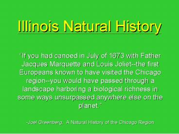
Illinois Natural History
- If you had canoed in July of 1673 with Father
Jacques Marquette and Louis Joliet--the first
Europeans known to have visited the Chicago
region--you would have passed through a landscape
harboring a biological richness in some ways
unsurpassed anywhere else on the planet. - -Joel Greenberg, A Natural History of the
Chicago Region
2
(No Transcript)
3
(No Transcript)
4
Geologic History
- One key to the rich biodiversity of present-day
Illinois lies in its varied geologic past. - This past was dominated by glaciation from
2,000,000 to 8,000 years b.p. - This repeated flattening by huge sheets of ice
has left us with the exciting landscape we have
today in northern Illinois. - Only far Southern Illinois escaped major
glaciation.
5
Geology continueda few interesting factoids
- Over 20 glacial advances and retreats have
occurred during the last 2 million years. - The Wisconsin glacial episode ended 20,000
years b.p. and the ice sheets have retreated
since - Approx. 13,000 years b.p. the last ice sheets
covered the Chicago region. - This glacier scooped out the future Lake Michigan
basin an additional 500-900 ft. - Glaciation of Illinois
6
Glaciation
Its more than just ice!
7
Glaciers Exist
- when snow remains after summers end
- on areas of high and low precipitation and
disparate temperatures - on all continents except Australia
- from high altitudes in equatorial regions to the
polar ice caps - on 10 of land and 12 of oceans
8
Moving sheets and rivers of ice
- Sharpen peaks and ridges
- Deepen valleys
- Bevel hills
- Rework the the surface on the ground
- Shape the land
9
Look for striations - they are the glaciers
signature.
10
(No Transcript)
11
How Ice Attacks the LandErosion and Deposition
- Glaciers advance during cold intervals
- Material being pushed along by the glacier
produces moraines. - Widens, deepens, and straightens a valley
- Moving ice creates striations pluck rocks and
drag them along - Make abrasions called striations
- Smooth out landscape
12
Types of Deposition
- Glaciers melt back, or recede during warm
intervals - Leave behind whatever they were carrying
13
Acts as a dam
14
(No Transcript)
15
Illinois Geology
- Four glacial advances Nebraskan, Kansan,
Illinoian, Wisconsinan glacial epochs - Wisconsinan - 15,000 years ago
16
So why is Skokie always flooding?
17
It all starts with soil, and soil starts with
rock.
- Use the animation and the slides that follow to
create your own, generalized rock cycle diagram - Rock Cycle Animation
18
(No Transcript)
19
(No Transcript)
20
(No Transcript)
21
Sedimentary Rock Slate, sandstone, limestone
Deposition
Transportation
Erosion
Heat, pressure, stress
Weathering
EXTERNAL PROCESSES
INTERNAL PROCESSES
Igneous Rock Granite, pumice, basalt
Metamorphic Rock Slate, marble, quartzite
Heat, pressure
Cooling
Melting
Magma (molten rock)
Fig. 10.8, p. 217
22
(No Transcript)
23
Examples of sedimentary rocks
Sandstone rocks
- small grains of the minerals quartz and
feldspar - look for layers - used as building s
tones.
24
Limestone rocks
- made from the mineral calcite sea animal
shells - used in concrete - excellent building s
tone for humid regions
25
Shale rocks
- formed from clay compacted together by
pressure - used to make bricks and other material
that is fired in a kiln
26
Conglomerate rocks
- made up of large sediments like sand and
pebbles - pressure alone cannot hold the rock tog
ether - cemented together with dissolved minerals
.
27
Gypsum rocks
- made up of sulfate mineral - result of evapora
ting sea water in prehistoric basins
- very soft - used to make Plaster of Paris, cas
ts, molds, and wallboards.
28
http//www.fi.edu/fellows/payton/rocks/create/meta
morph.htm
Metamorphic rocks
- Rocks that have"morphed" into another kind of
rock - Former igneous or sedimentary rocks
- Heat and pressure change rocks
- Look for flattened grains
29
Schist rocks
- Can be formed from basalt (igneous), shale
(sedimentary) or slate (metamorphic)
- Transformed by heat and pressure
30
Gneiss rocks
- These rocks may have been granite (igneous)
- Changed by heat pressure - Flattened mineral
grains
- Alternating patterns
31
http//www.fi.edu/fellows/payton/rocks/create/igne
ous.htm
- Formed either underground or above ground
- Underground - magma cools slowly - Above gr
ound - volcanoes erupt and lava cools
Igneous rocks
32
Granite rocks
- formed by slowly cooling pockets of magma
below - used for long lasting monuments and for
trim and decoration on buildings.
33
Scoria rocks
- formed when lava cooled quickly above ground
- look for little pockets -glass and not a mixtur
e of minerals
34
Pumice rocks
- formed when lava cooled quickly above ground.
- little pockets - very light will actually flo
at in water - glass - used as decorative landsca
pe stone - ground to a powder, used as an abrasi
ve in polish compounds and in Lava soap.
35
Obsidian rocks
- lava cools quickly above ground
- glass
- sharp edges
36
Lake
Tidal flat
Glacier
Spits
Shallow marine environment
Stream
Barrier islands
Lagoon
Dunes
Delta
Dunes
Beach
Shallow marine environment
Volcanic island
Coral reef
Continental shelf
Continental slope
Abyssal plain
Deep-sea fan
Continental rise
Fig. 10.7, p. 216
37
Chapter10-5 Soil Formation Degradation
38
Major Soil Components
- Soil is a complex mixture of eroded rock, mineral
nutrients, decaying organic mater, water, air and
billions of microorganisms. - A mature soils profile is arranged is specific
zones called horizons.
39
Soil Texture
- Soil texture is determined by the ratios of
- clay
- silt increasing
- sand size
- gravel
- The best agricultural soils (loams) have roughly
equal percentages of the above.
40
Lords and ladies
Oak tree
Word sorrel
Dog violet
Organic debris Builds up
Earthworm
Grasses and small shrubs
Rock fragments
Millipede
Mole
Moss and lichen
Fern
Honey fungus
O horizon Leaf litter
A horizon Topsoil
Bedrock
B horizon Subsoil
Immature soil
Regolith
Young soil
Pseudoscorpion
C horizon Parent material
Mite
Nematode
Actinomycetes
Root system
Fungus
Red earth mite
Springtail
Mature soil
Bacteria
Fig. 10.12, p. 220
41
Rove beetle
Pseudoscorpion
Flatworm
Centipede
Ant
Ground beetle
Mite
Roundworms
Adult fly
Fly larvae
Beetle
Springtail
Mites
Protozoa
Millipede
Bacteria
Sowbug
Slug
Fungi
Actinomycetes
Snail
Mite
Earthworms
Organic debris
Fig. 10.13, p. 221
42
Nitrogen fixing by lightning
Crop plant
Organic fertilizers, Animal manure, Green manure
, compost
Commercial inorganic fertilizer
10-6-4 N-P-K
Dead organic matter
Nitrogen fixing
Nutrient removal with harvest
Application to land
Decomposition
Absorption of nutrients by roots
Supply of available plant nutrients in soil
Nutrient loss by bacterial processes such as c
onversion
of nitrates to nitrogen gas
Weathering of rock
Fig. 10.14, p. 222
Nitrogen fixing by bacteria
Nutrient loss from soil erosion
43
Fig. 10.16, p. 224
44
- These varying particles also determine a soils
- Porosity- the amount of pores and air spaces
- Permeability - the rate at which air and water
move down into the soil - These many soil characteristics, as well as
nutrient availability and pH, determine what
plant and animal communities will ultimately live
in a given location.
45
Water
Water
High permeability
Low permeability
Fig. 10.17, p. 224
46
Forest litter leaf mold
Acid litter and humus
Acidic light- colored humus
Humus-mineral mixture
Light-colored and acidic
Light, grayish- brown, silt loam
Iron and aluminum compounds mixed with clay
Dark brown Firm clay
Humus and iron and aluminum compounds
Tropical Rain Forest Soil (humid, tropical climat
e)
Deciduous Forest Soil (humid, mild climate)
Coniferous Forest Soil (humid, cold climate)
Fig. 10.15b, p. 223
47
Mosaic of closely packed pebbles, boulders
Alkaline, dark, and rich in humus
Weak humus- mineral mixture
Dry, brown to reddish-brown with variable accum
ulations of clay, calcium carbonate, and solubl
e salts
Clay, calcium compounds
Desert Soil (hot, dry climate)
Grassland Soil (semiarid climate)
Fig. 10.15a, p. 223
48
Soil is a Precious Resource
- It takes 200-1000 years for 1 inch (2.5cm) of
topsoil to develop - Many studies have shown that worldwide, topsoil
is being lost more quickly than it is being
formed. - Because of soil conservation efforts erosion
rates in the U.S. have dropped by 40. - Still, in 1997 loss of topsoil and soil fertility
cost the U.S. 30 billion dollars.
49
Fig. 10.18, p. 225
50
Areas of serious concern
Areas of some concern
Stable or nonvegetative areas
Fig. 10.19, p. 226
51
Kansas
Colorado
Dust Bowl
Oklahoma
New Mexico
Texas
MEXICO
Fig. 10.20, p. 227
52
Guess on which side of the fence the sheep live?
Fig. 10.23, p. 229
53
- What is desertification?
- What measures and planting techniques can be
implemented to help hold on to precious topsoil?
54
Fig. 10.24a, p. 230
Terracing
55
Control planting and strip cropping
Fig. 10.24b, p. 230
56
Alley cropping
Fig. 10.24c, p. 230
Recommended
CrystalGraphics Presentations


