
Northridge, California M6.7 - PowerPoint PPT Presentation
1 / 18
Title: Northridge, California M6.7
1
(No Transcript)
2
Northridge, California (M6.7) - Depth range
about 3 to 11 miles -
Nisqually, Washington (M6.8) - Depth range about
30 to 36 miles -
10 30 50
Depth (Miles)
3
ShakeMap Flowchart
INPUT
Earthquake Info
Ground Motion Amplitudes
ShakeMap Processing Modules
ShakeEmail
PAGER
PUSH
WWW Pages
OUTPUT
4
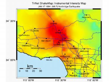
(No Transcript)
5
What Controls the Distribution of Shaking?
Magnitude Higher magnitude requires a larger
fault, so more energy is released over a larger
area, and shaking lasts longer.
Great 1857 Fort Tejon(Magn. 7.8) earthquake length
6
What Controls the Distribution of Shaking?
Magnitude
Distance from fault
Directivity
Soils (site conditions) amplify the shaking
7
1989 Magnitude 6.9 Loma Prieta Earthquake- Damage
distant from the epicenter
8
Example TriNet Station
9
TriNet Station Equipment
10
(No Transcript)
11
ShakeMap Input (Grid of points)
ftp Push
- SCEs Emiga System
- Knowledge of
- Crew Locations
- Substation Locations
Ground Motion Exceeds Threshold?
Page Facility Manager/Crew
12
Used at Los Angles Co. Emergency Operations
Center, By LA County Office of Emergency
Management for Training Scenario, November 9,
2000.
LA County Emergency Operations Center
13
(No Transcript)
14
What used to take hours, days, weeks, or even
months takes only minutes..
15
(No Transcript)
16
The End
Questions?
U.S. Department of the Interior U.S. Geological
Survey
17
Web Page Statistics
History from 08/01/99 -- 11/01/99
pasadena.wr.usgs.gov
18
(No Transcript)
Recommended
CrystalGraphics Presentations


