
Chapter 23 Introducing Europe - PowerPoint PPT Presentation
1 / 28
Title:
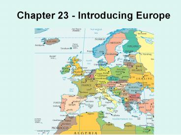
Chapter 23 Introducing Europe
Description:
The Alps are western and central Europe's. highest mountain range ... B. Europe's climate regions. Mediterranean climate in Portugal, Spain, ... – PowerPoint PPT presentation
Number of Views:597
Avg rating:5.0/5.0
Title: Chapter 23 Introducing Europe
1
Chapter 23 - Introducing Europe
2
Chapter 23 - Introducing Europe
- I. PHYSICAL GEOGRAPHY
3
I. PHYSICAL GEOGRAPHY
- Europe can be divided into 4 major
- landform regions
N. European Plain NW Highlands Central Uplands
The Alps
4
A. Europes major landforms
- 1. The Northwest Highlands
- The hills of
- Ireland and
- England, and
- the Scottish
- Highlands
5
1.The Northwest Highlands
- Brittany in
- northwestern
- France
6
1.The Northwest Highlands
- Most of the
- Iberian
- Peninsula
7
1.The Northwest Highlands
- The Kjølen
- Mountains
- in Norway
- and Sweden
8
2. The Northern European Plain
- The Northern European Plain is Europes
- largest landform region
9
2. The Northern European Plain
- The plain extends from the Atlantic coast of
France into Russia
10
2. The Northern European Plain
- It borders the North Atlantic Ocean, North Sea,
and Baltic Sea
11
3. The Central Uplands
- The Massif Central of France
12
3. The Central Uplands
- The Massif Central of France
The Massif Central is a large upland area in
south central France, covering about 1/6 of the
area of France. It reaches a high point of 1,886
m (6,188 ft) atop Puy de Sancy. Major sections
include a region of ancient lava flows and eroded
volcanic necks
13
3. The Central Uplands
- The Jura Mountains on the French-Swiss
- border
14
3. The Central Uplands
- The Jura Mountains on the French-Swiss
- border
The Jura consist of a series of parallel folds
in the strata, forming a plateau about 200 miles
long and 20 to 35 miles wide. These folded ridges
have many transverse fractures in the form of
steep gorges. The general height is about 3000 to
5000 ft. The Jura are formed of limestone rich in
fossils for this reason the Jurassic period was
named after the range.
15
3. The Central Uplands
- The Black Forest and Bavarian Plateau of Germany
16
3. The Central Uplands
- The Black Forest and Bavarian Plateau of Germany
Black Forest (Schwarzwald), is a wooded mountain
region in southwestern Germany. Its name refers
to the heavy stands of fir on the upper slopes.
Like much of the forest land in Germany, the
Black Forest is plagued by air pollution. Studies
have shown that as many as half the trees in the
Black Forest have been damaged by acid rain,
automobile emissions, and industrial pollution.
Maximum elevations in the southern region are
approx. 4,898 ft and 3,819 in the north. Numerous
rivers rise in the Black Forest.
17
3. The Central Uplands
- The Bohemian Highlands of Germany and
- the Czech Republic
18
3. The Central Uplands
- The Bohemian Highlands of Germany and
- the Czech Republic
Area dominated by the elevated plateaus of the
Bohemian-Moravian Highlands and the low plains
and rolling hills of the Bohemian Basin. A number
of rivers drain these areas, and much of the
countrys farmland is located there. Rising along
the edges of these central regions are a number
of mountain ranges. Forests in the Czech Republic
are among the most seriously affected by acid
rain in all of Europe.
19
3. The Central Uplands
- The Ardennes in the Benelux countries
20
3. The Central Uplands
- The Ardennes in the Benelux countries
- The name given to a hilly and wooded area
extending from France through Belgium and
Luxembourg to Germany. The hills slope gradually
to the northwest and are rarely above 1600 ft
high. Large sections consist of gently undulating
plateaus and other areas are marshy and covered
with heath.
21
4. The Alps
- The Alps are western and central Europes
- highest mountain range
22
4. The Alps
The Alps are a complex fold-mountain system.
Sedimentary deposits of vast thickness, mainly
limestone and dolomite, were laid down during the
Triassic and Jurassic periods. Subsequently,
enormous pressure generated by a collision
between the African and Eurasian plates thrust
these rock strata upward and northward to form
recumbent folds. The four glaciations of the
Quaternary period (beginning about 2.5 million
years ago) were of great importance in the
sculpturing of the Alps. Vast ice masses moved
through the valleys, transforming them into deep
troughs with steep walls. Glacial deposits dammed
the streams and rivers and produced the region's
many lakes.
23
4. The Alps
- The Alps extend from France,
- Switzerland, Austria, and Italy to the Balkan
- Peninsula
24
B. Europes climate regions
- Most of Europe has mild conditions
- throughout the year
25
B. Europes climate regions
- Europe has
- three major
- climate types
26
B. Europes climate regions
- Marine-west-coast climate Northern and West
Central Europe
27
B. Europes climate regions
- Humid-continental climate to the east and
- inland of the marine-west-coast climate
28
B. Europes climate regions
- Mediterranean climate in Portugal, Spain,
- Italy, Albania, Macedonia, Greece, and parts
- of France, Croatia, and Bulgaria
Recommended
CrystalGraphics Presentations


