
Hurricane Katrina : An American Catastrophe - PowerPoint PPT Presentation
1 / 223
Title: Hurricane Katrina : An American Catastrophe
1
Hurricane Katrina An American Catastrophe
2
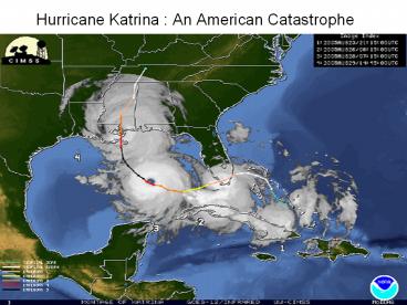
Hurricane Katrina An American Catastrophe
3
(No Transcript)
4
(No Transcript)
5
Vertical cross-section of New Orleans, showing
maximum levee height of 23 feet (7 m) at the
Mississippi river on the left and 17.5 feet (5 m)
at Lake Pontachartrain on the right.
6
Major Hurricanes Hitting NO
- Category Central
Pressure - at Landfall
- CAMILLE 1969 5 909
- KATRINA 2005 3 920
- ANDREW 1992 5 922
- LA (NEW ORLEANS) 1915 4 931
- LA (LAST ISLAND) 1856 4 934
- SE FL/SE LA/MS 1947 4 \940
- AUDREY 1954 4 945
- LA (CHENIER CAMINANDA) 1893 3 948
Table X
7
Hurricanes
- Table X Major Hurricanes to Have Crossed
Southeast Louisiana or Vicinity (1851-2004) - Source National Oceanic and Atmospheric
Administration (NOAA) Technical - Memorandum NWS TPC-4, The Deadliest, Costliest,
and Most Intense United States Tropical Cyclones
from 1851 to 2005 (and Other Frequently Requested
Hurricane Facts)
8
Hurricanes
- Hurricanes are intense low-pressure areas that
form over warm ocean waters in the summer and
early fall. - As warm, moist air rises from the ocean surface
into cooler air above, the water vapor condenses
to form droplets and clouds. - This condensation releases heat, boosting the
rise of the air, lowering the central pressure,
and drawing more warm, moist air into the storm. - In this manner, the energy builds up and the wind
speed increases. - The low pressure causes wind to spiral inward
toward the center of the low-pressure area,
creating the hurricane. - In the northern hemisphere, hurricane wind
rotation around the eye of a hurricane is
counter-clockwise
9
The Saffir-Simpson Hurricane Scale
- CATEGORY WIND SPEED (mph) TYPICAL STORM
- WATER SURGE (ft)
- 1 74 95 4 - 5
- 2 96 110 6 - 8
- 3 111 130 9 - 12
- 4 131 155 13 8
- 5 gt155 gt18
10
(No Transcript)
11
The Levees Background Information
- Flood protection a serious challenge for New
Orleans - It is mostly below sea level and frequently
besieged by high water from hurricanes, the
Mississippi River, and tropical downpours. - Outlines of today's system emerged in the early
1800s. - As 20th century approached, system was frequently
overwhelmed - wading to work through waist-deep water after a
heavy rain or high river was still common. - Advancements were made
- Electrical power resulted in larger and more
efficient pumps. - In 1896 legislature created the Drainage
Commission (Sewerage Water Board) to design a
drainage plan for the city.
12
The Levees Background Information
- By 1915 the new system was in place
- 70 miles of canals using the first of the most
powerful pumps on the planet screw pumps
designed by A.B. Wood. - System kept streets dry and helped drain the
backswamp making room for a period of explosive
growth across former wetlands. - Seeds for failure had been sowed by modern city
planners - Attempted to use the system to change the city's
ecosystem - With the city's support, developers aimed the
power of the pumps at the wetlands that lay
between the old city near the river and Lake
Pontchartrain. - Sections were dried out and developed.
- This continued relentlessly throughout the
decades, from the 40s, 50s, and 60s, to the late
1990s - This turned out to be a huge blunder. The profit
motive blinded officials, corporate management,
and everyone else involved in industrialization
and commercialization of the area
13
Background to Levee System
- In 1924 the state commissioned the Orleans Levee
Board to build new levees for Lake Pontchartrain - They built a concrete-stepped sea wall five miles
out from the lakeshore and used fill from the
lake to build 1,800 acres of new land behind the
wall. - By the late 1940s, the city's drainage network
had expanded the city's living space, but also
created some of the most unstable and flood-prone
property in America. - Higher levees kept the Mississippi River in its
banks, but also hastened the natural sinking of
the delta and put the city in a deepening bowl. - Increased drainage into Lake Pontchartrain
heightened the possibility of hurricane winds
pushing the lake back into the city through the
canals.
14
Background to Levee System
- Warnings about the drainage system and the city's
expansion plans had been around for almost 100
years. - In 1871, city surveyor W.H. Bell sounded what is
thought to be the first alarm about the dangers
posed by the big outfall canals. - Told city officials to place pumping stations on
the lakeshore, otherwise "heavy storms would
result in water backup within the canals,
culminating in an overflow into the city." - Warning was ignored (O, SC)
- In 1915 a powerful hurricane hit the city and
proved Bell right - The storm's surge pumped the lake 6 feet above
normal. - Outfall canals flowed over their levees, much of
the city flooded. - New Orleans' drainage system was overwhelmed,
even before the storm knocked out the electrical
station that ran the pumps.
15
Background to Levee System
- Levees along the canals were raised
- Considered the solution after almost every storm
during the next several decades - After 1947 hurricanes, New Orleans officials
urged state's congressional delegation to ask the
federal government to assist in protecting the
city. - Federal involvement became official in 1955
- Congress authorized the initial planning for the
Lake Pontchartrain and Vicinity Hurricane
Protection Project. - Clash of goals and cultures between the local
agencies and the Army Corps of Engineers did
little to address the dangers in the system (O,
SC)
16
Background Levees
- Outfall canals lacking because drainage had
always been a local responsibility. - Unlike the Industrial Canal, these canals weren't
used for navigation, so there was little Corps
interest in them (O, SC) - When forced by Congress to focus on the canals,
the Corps quickly found itself in conflict with
local interests about how to end the threat the
canals posed during a hurricane (O, SC). - In 1965 Hurricane Betsey caused heavy flooding
- Congress gave the US Army Corps of Engineers sole
authority for the design and construction of the
flood protection in Greater New Orleans in the
Pontchartrain Hurricane Protection Project. - Projected to take 13 years to complete
- When Katrina struck in 2005, the project was
between 60-90 complete and the projected date of
completion was estimated to be 2015, nearly 50
years after it first gained authorization (O,
SC).
17
Hurricane Betsy
- Betsy was a fast moving storm (22 mph forward
speed) that made landfall at Grand Isle, LA on
September 10, 1965. - The central pressure at landfall was 948 mb.
- Grand Isle experienced 160 mph gusts and a 4.8 m
(15.7 ft) storm surge that flooded the entire
island. - Winds gusted to 125 mph in New Orleans with a 3.0
m (9.8 ft) storm surge that caused the worst
flooding in decades. - Winds reached 100 mph over most of southeast
Louisiana and exceeded 60 mph as far inland as
Monroe, LA. - Offshore oil rigs, public utilities, and
commercial boats all suffered severe damage. - Loss of life from Betsy was a total of 81
persons, with 58 in the state of Louisiana. - Damage in Southeast Louisiana totaled 1.4
billion. - The Orleans Levee Board raised the existing levee
to a height of 12 ft in response to the flooding
caused by Betsy.
18
Background -- Levees
- Congress first authorized construction of the
Lake Pontchartrain and Vicinity, including the
city of New Orleans, Louisiana Hurricane
Protection Project (LHPP) in the Flood Control
Act of 1965 - Although federally authorized, From the
beginning, the LHPP was a joint federal, state,
and local effort - The federal government agreed to pay 70 percent
of the costs - The state and local interests would pay the
remaining 30 percent - The Army Corps of Engineers (ACE) was responsible
for project design and construction - Local interests were responsible for maintenance
of levees and flood controls.
19
Background Levees
- The original project design, known as the Barrier
Plan, included a series of levees along the
lakefront, concrete floodwalls along the Inner
Harbor Navigation Canal, and control structures,
including barriers and flood control gates
located at the Rigolets and Chef Menteur Pass
areas. - These structures were intended to prevent storm
surges from entering Lake Pontchartrain and
overflowing the levees along the lakefront. - The original lakefront levees were planned to be
from 9.3 feet to 13.5 feet high depending on the
topography of the area directly in front of the
levees - The cost estimate for the original project was
85 million (in 1961 dollars) and the estimated
completion date was 1978
20
Background Levees
- The Barrier Plan was selected over another
alternative, known as the High-Level Plan, which
excluded the barriers and flood control gates at
the Rigolets and Chef Menteur Pass complexes and
instead employed higher levees ranging from 16
feet to 18.5 feet high along the lakefront to
prevent storm surges from inundating the
protected areas. - In the 1960s, the barrier plan was favored
because it was believed to be less expensive and
quicker to construct. - This decision was reversed in the mid-1980s.
21
Levee Construction
- Original late 1960s project designs developed to
combat a hurricane that might strike the coastal
Louisiana region once in 200-300 years (Risk
Assessment Model). - The basis for this late 1960s risk assessment
model was developed by the Corps with the
assistance of the United States Weather Bureau
(now the National Weather Service). - The model was intended to represent the most
severe meteorological conditions considered
reasonably characteristic for that region. - The model projected a storm roughly equivalent to
a fast-moving Category 3 hurricane. - A Category 3 hurricane has winds of 111-130 miles
per hour and can be expected to cause some
structural damage from winds and flooding near
the coast from the storm surge and inland from
rains.
22
Background Levees
- The levees were designed for a Category 3 storm,
assuming that nothing changed - Assuming that New Orleans would not sink any
further, when government officials knew it was
sinking. - Engineers and Administrators acted as though the
barrier islands, which lessen a hurricanes
impact, would stay in place when they knew the
islands were continuing to erode - They acted as though the marshes, which absorb a
hurricanes energy, would stay the same when
they knew the marshes were disappearing and would
continue to disappear.
23
Levee Construction
- During the first 17 years of construction on the
barrier plan, the Corps continued to face project
delays and cost increases due to - design changes caused by technical issues,
- environmental concerns,
- legal challenges, and
- local opposition to various aspects of the
project (Inadequate Risk Communication
Strategies).
24
Levee Construction
- foundation problems were encountered during
construction of levees and floodwalls which
increased construction time - delays were encountered in obtaining
rights-of-ways from local interests who did not
agree with all portions of the plan (SC). - By 1981, cost estimates had grown to 757 million
for the barrier plan, not including the cost of
any needed work along the drainage canals, and
project completion slipped to 2008. - At that time, about 171 million had been made
available to the project and the project was
considered about 50 percent complete
25
Levee Construction
- The Corps used data provided by the U.S. Weather
Bureau that was outdated - Data was used that was developed during the 30s
and 40s - New, sophisticated technologies used by the
Weather Bureau over the decades since the 40s,
could produce better, more scientific data - Changing meteorological conditions were also
recorded by the Bureau since the 40s - The original plans used by the Corps only
included the early data and not new data the
Bureau developed - The new data was more relevant, accurate, and
showed the need for a much stronger protection
plan
26
Levee Construction
- The United States Congress directed the USACE to
design the hurricane protection system for the
most severe combination of meteorological
conditions that are considered reasonably
characteristic of the region. - The USACE use the concept of the standard
project hurricane (SPH) when they design
structures to protect against hurricanes
27
Levee Construction
- In 1965, in the wake of the destruction of the
city of New Orleans from Hurricane Betsy, the
USACE chose to use the United States Weather
Bureaus (now the National Weather Service) 1959
National Hurricane Research Project Report 33,
Meteorological Considerations Pertinent to
Standard Project Hurricane, Atlantic and Gulf
Coasts of the United States. for the
determination of site specific storm
meteorological criteria - Facilities and structures were then designed to
withstand the impacts of the Standard Project
Hurricane. - The USWBs report criteria were based on historic
hurricanes from 1900 to 1956.
28
Levee Construction
- In 1979, NOAA issued Technical Report NWS 23,
Meteorological Criteria for Standard Project
Hurricane and Probable Maximum Hurricane
Windfields, Gulf and East Coasts of the United
States. - This report contained revised criteria for the
SPH, incorporating the characteristics of more
recent hurricanes, including Hurricane Betsy,
which directly hit New Orleans. - The West Bank and Vicinity Hurricane Protection
Project was designed and constructed after Report
NWS 23 was issued. - It does not appear that the USACE used the
updated SPH criteria (ASCE ERP report on the IEP)
29
Levee Construction
- To start, the USACE used meteorological and
oceanographic analysis based on the 1959 1 in 100
year Standard Project Hurricane (SPH) - However, this was known to be obsolete by 1972,
just as construction of initial parts of the
levee system of NO was beginning. - A major deficiency of the 1959 SPH was in the
specification of maximum sustained wind speed,
which the National Weather Service (NWS) had
increased by 20 percent, from 107 to 129 mph. - This data was used by the USACE as a design basis
for setting the minimum heights above mean sea
level for levee and floodwall crowns to resist
overtopping by combined SPH waves and surge. - A 20 percent underestimate of maximum winds can
lead to a 40 percent reduction in the predicted
surge elevation. - In 1979 the NWS raised the maximum sustained
winds to 140 MPH, a category 4 hurricane!
30
Levee Construction
- The USACE was aware of this deficiency in the
original analysis, as shown by testimony in 1976
and 1982 General Accounting Office (GAO) reports - However, the USACE never revised the original
SPH-based analysis to reflect the new
understanding of the threats, even after being
ordered to do so by the Chief of Engineers in
1981 (Team Louisiana). - New Orleans residents were not advised that the
GNO HPS required significant improvements to meet
1 in 100 year SPH requirements, but, instead, the
New Orleans District claimed at times that the
GNO HPS would protect against a 1 in 200 to 1 in
300 year hurricane. - No basis for this claim has been established,
while numerous storms that have affected the GNO
area before and after the 1965 initiation of
the HPS -- were more severe than the 1959 SPH.
31
http//www.gao.gov/new.items/d06244t.pdf
32
Levee Construction
- During the 1970s, some features of the barrier
plan faced opposition from environmentalists and
local groups concerned about environmental
damages to the lake and inadequate protection. - Threat of litigation by environmentalists delayed
the project - Opposition culminated in December 1977 court
decision that enjoined the Corps from
constructing the barrier complexes until a
revised environmental impact statement was
prepared and accepted (Poor Risk Communication
Model). - After the court order, the Corps decided to
change course and completed a project
reevaluation report and prepared a draft revised - Environmental Impact Statement in the mid-1980s
recommended abandoning the barrier plan and
shifting to the high-level plan originally
considered in the early 1960s. - The level of protection provided to New Orleans
was not expected to change because the high-level
design was expected to provide the same level of
protection as the original barrier design.
33
Levee Construction
- As of 2005, the project as constructed included
about 125 miles of levees and the following major
features - New levee north of Highway U.S. 61 from the
Bonnet Carré Spillway East Guide Levee to the
Jefferson-St. Charles Parish boundary - Floodwall along the Jefferson-St. Charles Parish
boundary - Enlarged levee along the Jefferson Parish
lakefront - Enlarged levee along the Orleans Parish lakefront
- Levees, floodwalls, and flood proofed bridges
along the 17th Street, Orleans Avenue and London
Avenue drainage canals - Levees from the New Orleans lakefront to the Gulf
Intracoastal Waterway - Enlarged levees along the Gulf Intracoastal
Waterway and the Mississippi River-Gulf Outlet - New levee around the Chalmette area.
- The project also includes a mitigation dike on
the west shore of Lake Pontchartrain.
34
Levee Construction Budget
- Federal money for the project was 458 million as
of the enactment of the fiscal year 2005 federal
appropriation. - This comes to 87 percent of the Federal
governments responsibility of 528 million, with
70 million remaining to complete the project in
2015. - Over the last 10 fiscal years (1996-2005),
federal appropriations have totaled about 128.6
million - Corps reprogramming actions resulted in another
13 million being made available to the project. - During that time, appropriations have generally
declined from about 15-20 million annually in
the earlier years to about 5-7 million in the
last three fiscal years. - While this may not be unusual given the state of
completion of the project, the Corps project
fact sheet from May 2005 noted that the
Presidents Budget request for fiscal years 2005
and 2006 and the appropriated amount for fiscal
year 2005 were insufficient to fund new
construction contracts.
35
Levee Construction
- According to the ACE, construction efforts that
could not be funded - Levee enlargements in all four parishes
- Pumping station flood protection in Orleans
Parish - Floodgates and a floodwall in St. Charles Parish
- Bridge replacement in Orleans Parish.
36
Hurricane Katrina CatastropheBernard
ParishLevee Breech
37
Levee Construction
- Pre-Katrina estimated cost of construction for
the completed project was 738 million with the
federal share being 528 million and the local
share 210 million. - The estimated completion date as of May 2005 for
the whole project was 2015. - Prior to Katrina, the project was estimated to be
from 60-90 percent complete in different areas. - The work in Orleans Parish was estimated to be 90
percent complete - Some work remaining for bridge replacement along
the Orleans Avenue and London Avenue drainage
canals. - The floodwalls along the canals were complete.
38
Levee Construction
- Jefferson Parish work was estimated to be 70
percent complete - Work continuing on flood proofing the Hammond
Highway bridge over 17th Street and two lakefront
levee enlargements. - Estimated completion for that work was 2010.
- In the Chalmette area work was estimated to be 90
percent complete - Some levee enlargement work and floodwall work
remaining. - In St. Charles Parish work was 60 percent
complete - Some gaps still remaining in the levees.
- Closure of these gaps had been scheduled to be
completed by September 2005.
39
Levee Construction
- The hurricane protection system was funded on a
project-by project basis over many years. - As a result, the system was constructed in a
piecemeal fashion. - In addition, there were pressures for tradeoffs
and low-cost solutions that compromised quality,
safety, and reliability. (ASCE ERP Report)
40
Hurricane Katrina
- Hurricane Katrina struck the area on August 29,
2005 - Flood walls and levees catastrophically failed
throughout the metro area. - Many collapsed well below design thresholds (17th
Street and London Canals). - Others collapsed after a brief period of
overtopping (Industrial Canal) caused by
scouring or erosion of the earthen levee walls
an egregious design flaw. - Scientists worldwide refer to the flooding of New
Orleans as the worst engineering disaster in US
History.
41
Hurricane Katrina
- Five investigations were conducted by civil
engineers and other experts, in an attempt to
identify the underlying reasons for the failure
of the federal flood protection system designed
and constructed by the US Army Corps of
Engineers. - In total, the federal flood protection system
protecting greater New Orleans failed in 53
places. - Designs approved by the corps were too weak to
cope with the shaky soils left by the swamps
drained decades before most of the breaches
occurred before the canals were filled to the
stated design capacity
42
Hurricane Katrina Worst Flood in U.S.
History Unprecedented Drowning of an entire
American City
- In the wake of the failures, officials are
finally taking W.H. Bell's warnings seriously. - The federal government has announced it will
repair the levees to pre-Katrina heights, sorting
out any design flaws in the process. More
important, it will pay to have the pumping
stations moved to the lakefront -- just as Bell
urged 130 years ago. - The most severe loss of life and property damage
occurred in New Orleans, which flooded as the
levee system failed catastrophically - Hurricane Katrina was the costliest and one of
the deadliest hurricanes in the history of the
United States.
43
Geography of New Orleans
44
Geography of New Orleans
The city of New Orleans is situated between the
Mississippi River, which passes along the
southern edge of the main portion of the city And
Lake Pontchartrain, which fronts the city to the
north, and Lake Borgne (which is really a bay),
which flanks the city on the east
45
Geography of New Orleans
The flood protection system that protects New
Orleans region is organized As a series of
protected basins, each protected by its own
perimeter levee system, And emptied out by a
series of pumps
46
Overview of Levee Damage
- The Lake Pontchartrain and Vicinity Hurricane
Protection Project system experienced the worst
damage during and after Hurricane Katrina and
resulted in the most serious consequences to the
city and people of New Orleans. - The massive, destructive flooding of New Orleans
was caused by ruptures at approximately 53
locations in the citys hurricane protection
system. - Of the 284 miles of federal levees and
floodwallsthere are approximately 350 miles in
total169 miles were damaged
47
- New Orleans flood protection system can be
divided into - 4 regions of protected area
- Orleans Parish, which contains Downtown and New
Orleans East - St Bernard Parish, which contains the densely
populated Ninth Ward - Jefferson Parish
- Plaquemines Parish
48
New Orleans Flood Protection Systems by
Region Showing the Various Breeches
Blue Star levee breech Red Star distress or
partial breech Yellow Star deliberate breech
49
Geography of New Orleans Contiguously Protected
Area 1
- Metro New Orleans, including the French Quarter
and Canal District - Northern edge fronted by Lake Pontchartrain,
southern edge by Mississippi River - Inner Harbor Navigation Canal (IHNC) or the
Industrial Canal passes along the east flank,
separating Orleans East Bank from New Orleans
East (to the NE) and from Lower Ninth Ward and
St. Barnard Parish (due E) - Three Large drainage canals extend into New
Orleans East Bank for the purpose of pumping
water out of the city and into the Lake - Canals from W to E 17th Street Canal, Orleans
Canal, London Ave. Canal
50
(No Transcript)
51
The Levee protection system is outlined in blue
52
(No Transcript)
53
(No Transcript)
54
(No Transcript)
55
(No Transcript)
56
Geography of New Orleans Contiguously Protected
Area 1
- New Orleans East
- Lake Pontcartrain along north edge
- Inner Harbor Navigation Canal (IHNC) along west
flank - Southern edge fronted by Mississippi River Gulf
Outlet (MRGO), which co-exists with the Gulf
Intercoastal Waterway (GIWW) along this stretch - Eastern portion largely unprotected swampland and
fronted by Lake Borgne
57
Geography of New Orleans Contiguously Protected
Area 2
- Contains St. Bernard Parish and Lower Ninth Ward
- Fronted by IHNC on west flank and MRGO/GIWW
channel along northern edge - At NE corner MRGO bends to south away from GIWW
and fronts boundary of this protected area along
northeastern edge - Open swampland occurs to south and southeast
- Lake Borgne occurs to the east, separated from
this protected area by MRGO channel and strip of
swampland
58
Geography of New Orleans Contiguously Protected
Area 3
- Plaquemines Parish
- Narrow protected strip along lower reached of the
Mississippi River heading south from St. Bernard
Parish to mouth of the river to the Gulf of
Mexico - Serves to protect communities and utilities and
gas and oil pipelines
59
- New Orleans regional flood protection system can
be divided into - 4 zones of failure
- Plaquemines Parish
- The East Flank New Orleans East and the St.
Bernard/Lower Ninth Ward - The Central Region the IHNC and the GIWW/MRGO
Channel Frontages - The Lake Pontchartrain Frontage, and the Drainage
Canals
60
Plaquemines Parish Levee Failure
- Homes in these areas are sandwiched between two
sets of levees one along the river and the other
behind the towns. - The front levees were constructed along both
sides of the river and were designed with crest
elevations of approximately 25 feet. - The back levees had smaller crest elevations of
approximately 17 to 18 feet. - Storm surges up to 20 feet overtopped and damaged
many portions of the storm levees. - River sides of the levees were paved with
concrete slope protection and suffered little
damage. - Storm levees were built with soil that easily
eroded.
61
The East Flank New Orleans East and the St.
Bernard/Lower Ninth WardLevee Failure
- Protected by levees along Lake Borgne (actually
a bay that connected directly to the Gulf of
Mexico) - Levees were constructed using materials dredged
from the excavations for the MRGO and GIWW
channels. These materials, sand and lightweight
shell-sand are easily erodeable materials. - No swamp or cypress groves on the outboard side
of these levees which would have reduced storm
driven waves hitting these frontages. - These levees were mostly directly exposed to
severe driven waves across a large body of open
water. - Some parts of the levee which did not fail as
badly despite being overtopped were comprised of
compacted clay soils. - Many sections had crest heights and floodwall
heights 1 to 2 feet below intended design grade
which contributed to the overtopping of the
levees.
62
Flooding in Saint Bernards Parish Including the
Ninth Ward
63
The Central Region the IHNC and the GIWW/MRGO
Channel Frontages Levee Failure
- 1965 Army Corps complete 76-mile, 36-foot deep
Mississippi River Gulf Outlet - Created a navigation shortcut to the Port of New
Orleans, very little used but it created a funnel
that would accelerate and enlarge any storm
surges headed for the citys levees. - Storm surges could be amplified by 20-40
- There were many transitions between the
different sections of the levees including
inconsistent crest height, change in level type
(I-wall vs. T-wall), change in material
(concrete, steel sheetpile, earth), and
transitions where certain rights-of-way resulted
in penetration of the flood control system. - In the few cases of levee overtopping, the weaker
material at the point of transition (earth to
concrete, sheetpile to concrete, earth to sheet
pile) was more susceptible to failure. - Many of these transitions were owned by different
agencies and when they came together the weakest
(or lowest) segment or element controlled the
overall performance.
64
The Central Region the IHNC and the GIWW/MRGO
Channel Frontages Levee Failure
- 1980s Soil Test Conducted showed trouble 20 feet
below the surface a thick layer of spongy,
organic soil called peat. Peat becomes weak with
water saturation. - 1988 Corps performed soil test and determined the
concrete and steel floodwall anchored to the
earth by steel pilings must be driven to a depth
of 20 feet. - Tips of the sheet piles did not penetrate the
peat therefore underseepage occurred weakening
the protection system. - Overestimation in the strength of the soil in
many cases. - Borings from the drilling during testing were
lumped together which was not uncommon but the
New Orleans Area had too much geologic
variability for this to be a reliable method. - Drillings were performed at centerline of levee
were soil is most consolidated and strengthened.
Soil strength below and beyond levee was not
taken into consideration by USACE.
65
The Central Region the IHNC and the GIWW/MRGO
Channel Frontages Levee Failure
- 17th Street Canal failure
- 0.13 tons per square foot soil strength at breech
site compared against engineers design of 0.19
tsf. - Water filled gap behind wall reduced the factor
of safety by 30. This caused the overall factor
of safety to be reduced to one which meant
failure was imminent. - West bank failure at the CSX railroad crossing.
This site failed during Hurricane Betsy-1965,
which afterwards is when the decision to
construct the flood protection system was made. - Rolling steel floodgate was removed due to a
train accident months before Katrina and replaced
with sand bag embankment which easily washed away
during storm. - Not clear who owned this section of the levee.
66
The 17th Street Canal Breach
67
(No Transcript)
68
London Ave Canal Breach South
69
London Ave Canal Breach North
70
Hurricane Katrina Catastrophe Sheet Piles
71
The Lake Pontchartrain Frontage, and the Drainage
Canals
- There were several transitions which were
comprised of various materials and again the
lower weaker material set the performance of that
section of levee failure. - Floodwalls crest were very low allowing
overtopping to occur into the drainage canals
from the storm surges. - The canals were supposed to drain into the lake
which was exactly where water was coming from
creating a viscous cycle. - An archaic analysis method, the Method of Planes,
was used for most stability calculations. - This method (involving three blocks or wedges,
and a conservative side force assumption between
wedges) provides a demonstrated conservative
answer for cases to which it can be applied. It
is inflexible with regard to geometry and was
unable to deal with non-level stratigraphy and
curvilinear failure surfaces.
72
The Lake Pontchartrain Frontage, and the Drainage
Canals
London Avenue Canal-South Breech Soil beneath
canal was sand beneath marsh layer. Underseepage
and subsurface erosion problems were well known
by USACE for decades. Water filled gaps behind
the wall were again a problem just as in the case
of the 17th Street Canal breech.
73
London Avenue Canal-North BreechSame
situation as the south breech but soil was even
worse. Experienced water filled gap as well. If
there had been no gap canal had factor of safety
of 2.0-success.
74
Tons of sand were washed out from beneath the
levee and floodwall at the London Avenue Canal
South Breach and flowed into the adjacent
neighborhood. (This photo wastaken after
floodwaters had been removed.)
75
- Industrial Canal East/West Bank Breeches
- Floodwater overtopped I-walls by an estimated 1.7
feet. - Soil conditions were marsh on top of soft clay on
top of sand-not very stable conditions.
76
- Industrial Canal West South Bank and other levee
breeches - No I-wall in these levees.
- Levees constructed primarily of silt and sand or
with hydraulic fill-levee material mixed with
water to create a slurry, then pumped or flowed
into place suffered the worse erosion damage.
77
(No Transcript)
78
Levee Protection System
- Panel 1 is rendered from a 3 meter per pixel
National Elevation Database Digital Elevation
Model (NED DEM). - Pane 2, center, is a mosaic of 11 high resolution
(4096 x 4096 pixels each) aerial photographs
taken by NOAA shortly after the storm. - Overlaid on Panel 2 is a graphic representation
of the Hurricane Protection Levee System - sections that survived Katrina visibly intact
displayed in green, - levee sections which show visible evidence of
being overtopped by storm surge displayed in
yellow, - visibly breached sections displayed in red.
- The orange polygons indicate city blocks of
structures shown by the DEM rendering, which have
been erased by the storm, levee breaches, and
subsequent flooding - Panel 3 is a street map of the area, with the
Hurricane Protection Levee System again overlaid
using the same color coding system as Panel 2.
79
Panel 1 (left) shows the main surge from the
Intercoastal Waterway entering the Industrial
Canal. It is unclear whether the red section of
levee breached or was topped for a sustained
period of time, but a significant amount of water
entered the protected area here, enough to knock
several railroad cars off their tracks and float
Conex shipping containers several hundred yards
from their original positions.
80
Sequence of Levee Failures
81
Summary of Damage
82
Summary of Damage
83
Summary of Damage
84
Hurricane Katrina Timeline
Were facing the storm most of us have feared.
This is going to be an unprecedented event. -
Mayor of New Orleans, Ray Nagin
85
- The following timeline outlines the occurrences
leading up to and shortly - after the impact of Hurricane Katrina and the
levee failures - Friday, August 26
- GOV. KATHLEEN BLANCO DECLARES STATE OF EMERGENCY
IN LOUISIANA - GULF COAST STATES REQUEST TROOP ASSISTANCE FROM
PENTAGON - Saturday, August 27
- GOV. HALEY BARBOUR DECLARES STATE OF EMERGENCY IN
MISSISSIPPI - 5AM CDT KATRINA UPGRADED TO CATEGORY 3
HURRICANE - GOV. BLANCO ASKS BUSH TO DECLARE FEDERAL STATE OF
EMERGENCY IN LOUISIANA - FEDERAL EMERGENCY DECLARED, DHS AND FEMA GIVEN
FULL AUTHORITY TO RESPOND TO KATRINA - FEMA is authorized to identify, mobilize, and
provide at its discretion, equipment and
resources necessary to alleviate the impacts of
the emergency - At 500 PM CDT, New Orleans Mayor Ray Nagin
announced a state of emergency and a called for a
voluntary evacuation. He added that he would
stick with the state's evacuation plan and not
order a mandatory evacuation until 30 hours
before the expected landfall - Sunday, August 28
- 2AM CDT KATRINA UPGRADED TO CATEGORY 4
HURRICANE (145 mph winds) - 7AM CDT KATRINA UPGRADED TO CATEGORY 5
HURRICANE (175 mph winds) (902 mbar pressure) - MORNING LOUISIANA NEWSPAPER SIGNALS LEVEES MAY
GIVE
86
Hurricane Katrina Timeline
- Sunday, August 28
- 10 AM CDT Nagin declared that "a mandatory
evacuation order is hereby called for all of the
parish of Orleans." "We're facing the storm most
of us have feared," he told the early-morning
news conference, with the governor at his side. - AFTERNOON BUSH, BROWN, CHERTOFF WARNED OF LEVEE
FAILURE BY NATIONAL HURRICANE CENTER DIRECTOR - Dr. Max Mayfield, director of the National
Hurricane Center We were briefing them way
before landfall. Its not like this was a
surprise. We had in the advisories that the levee
could be topped. - 4PM CDT NATIONAL WEATHER SERVICE ISSUES SPECIAL
HURRICANE WARNING - LATE PM REPORTS OF WATER TOPPLING OVER LEVEE
- APPROXIMATELY 30,000 EVACUEES GATHER AT SUPERDOME
WITH ROUGHLY 36 HOURS WORTH OF FOOD - Monday, August 29
- 7AM CDT KATRINA MAKES LANDFALL in LA near NO AS
A CATEGORY 4 HURRICANE - 730 AM CDT BUSH ADMINISTRATION NOTIFIED OF THE
LEVEE BREACH - 8AM CDT MAYOR NAGIN REPORTS THAT WATER IS
FLOWING OVER LEVEE - 814 CDT -- At approximately 814 AM CDT (1314
UTC), the New Orleans office of the National
Weather Service issues a Flash Flood Warning for
Orleans Parish and St Bernard Parish, citing a
levee breach at the Industrial Canal.
87
Hurricane Katrina Timeline
- Monday, August 29
- By 900 AM CDT (2100 UTC), there was 6-8 feet of
water in the Lower Ninth Ward - 1113 AM CDT - WHITE HOUSE CIRCULATES INTERNAL
MEMO ABOUT LEVEE BREACH - Afternoon BROWN WARNS BUSH ABOUT THE POTENTIAL
DEVASTATION OF KATRINA - Afternoon MAYFIELD WARNS BUSH ABOUT THE TOPPING
OF THE LEVEES - 200 PM a Large Section of the 17th Street Canal
Levee was breached as well as confirmation of
breaches at two other canals - 8PM CDT GOV. BLANCO AGAIN REQUESTS ASSISTANCE
FROM BUSH
88
Hurricane Katrina Timeline
- Monday, August 29
- PRESIDENT BUSH ORGANIZES TASK FORCE TO COORDINATE
FEDERAL RESPONSE - JEFFERSON PARISH EMERGENCY DIRECTOR SAYS FOOD AND
WATER SUPPLY GONE - 80,000 BELIEVED STRANDED IN NEW ORLEANS
- 3,000 STRANDED AT CONVENTION CENTER WITHOUT FOOD
OR WATER - PUBLIC HEALTH EMERGENCY DECLARED FOR ENTIRE GULF
COAST - BUSH SURVEYS DAMAGE FROM AIR FORCE ONE
- CHERTOFF EXTREMELY PLEASED WITH THE RESPONSE OF
THE GOVERNMENT - EARLY AM BLANCO AGAIN TRIES TO REQUEST HELP
FROM BUSH - 4PM CDT BUSH GIVES FIRST MAJOR ADDRESS ON
KATRINA - 8PM CDT FEMA DIRECTOR BROWN CLAIMS SURPRISE
OVER SIZE OF STORM
89
Hurricane Katrina Timeline
- Tuesday, August 30 2005
- At 1200 PM CDT Homeland Security Secretary
Michael Chertoff first becomes aware that the New
Orleans levee breaches could not be plugged - Governor Blanco ordered that all of New Orleans,
including the Superdome, be evacuated due to the
flooding of the city.
90
Hurricane Katrina Timeline
- Wednesday, August 31, 2005
- 1000 PM CDT, Mayor Ray Nagin announced that the
planned sandbagging of the 17th Street Canal
levee breach had failed. At the time, 85 of the
city was underwater. - Michael Chertoff released a memo to other cabinet
members and the Environmental Protection Agency
stating that, "the President has established the
'White House Task Force on Hurricane Katrina
Response.' He will meet with us tomorrow to
launch this effort." - The memo also declared Hurricane Katrina to be an
Incident of National Significance and designated
Michael Brown, Under-Secretary for Emergency
Preparedness and Response (EPR), as the
Principal Federal Official (PFO) for incident
management purposes. - President Bush returned early to Washington from
vacationing at his ranch in Crawford, Texas.
Though he does not stop in Louisiana, Air Force
One flies low over the Gulf Coast so that he can
view the devastation in Air Force One for a
momentary photo opportunity. He later declared a
Public Health Emergency for the Gulf Coast.
91
Hurricane Katrina Timeline
- Thursday, September 1 (Three Days After the
Levees Broke and released a deluge on the city of
New Orleans) - 7AM CDT BUSH CLAIMS NO ONE EXPECTED LEVEES TO
BREAK - STILL NO COMMAND AND CONTROL ESTABLISHED
- 2PM CDT MAYOR NAGIN ISSUES DESPERATE SOS TO
FEDERAL GOVERNMENT - NEW ORLEANS DESCENDS INTO ANARCHY
- No food, potable water, medical supplies
available for the tens of thousands stranded in
the Superdome and elsewhere - MICHAEL BROWN LEARNS OF EVACUEES IN CONVENTION
CENTER - Secretary Chertoff is criticized by NPR's Robert
Siegel during an interview on All Things
Considered, as he had no knowledge of the
approximately 2,000 survivors at the Convention
Center with no food or water. He said, "I have
not heard a report of thousands of people in the
Convention Center who don't have food and water."
92
Hurricane Katrina Timeline
- Thursday, September 1
- ROVE-LED CAMPAIGN TO BLAME LOCAL OFFICIALS BEGINS
- BUSH VISIT GROUNDS FOOD AID
- LEVEE REPAIR WORK ORCHESTRATED FOR PRESIDENTS
VISIT - 12PM CDT BUSH SATISFIED WITH THE RESPONSE
- PM FEMAS NO. 2 OFFICIAL IMPRESSED WITH
GOVERNMENT RESPONSE - CONGRESS APPROVES INITIAL FUNDING
93
Hurricane Katrina Timeline
- Saturday, September 3
- SENIOR BUSH ADMINISTRATION OFFICIAL LIES TO
WASHINGTON POST, CLAIMS GOV. BLANCO NEVER
DECLARED STATE OF EMERGENCY - 9AM CDT BUSH BLAMES STATE AND LOCAL OFFICIALS
- 805PM CDT FEMA FINALIZES BUS REQUEST
- CHERTOFF CLAIMS THAT NO ONE COULD HAVE PREDICTED
KATRINA - THE LOUISIANA SUPERDOME IS FULLY EVACUATED
- Thursday, September 8
- CONGRESS APPROVES MORE RELIEF FUNDING
- Friday, September 9
- BROWN STRIPPED OF RELIEF DUTIES
- Monday, September 12
- FEMA DIRECTOR RESIGNS
- Tuesday, September 13
- BUSH TAKES RESPONSIBILITY FOR FLAWED RESPONSE
- Katrina exposed serious problems in our
response capability at all levels of government,
Mr. Bush said. And to the extent that the
federal government didnt fully do its job right,
I take responsibility.
94
Levee Before and After Hurricane Katrina
95
Breach in 17th Street Canal levee
96
Sketch of New Orleans (shaded grey), indicating
the locations of the principal breaches in the
levees/floodwalls (dark blue arrows). Red dots
show locations of deaths.
97
- Tuesday, August 30
- TENS OF THOUSANDS TRAPPED IN SUPERDOME
CONDITIONS DETERIORATE
98
Hundreds of Citizens are Stranded on Their Roof
Tops
99
People Drowned Right in the Streets
100
Results of Levee Failures
- Loss of Life
- Communication System Failures
- Damage to Buildings and Roads
- Civil Disturbance
- Socio-Economic Disparity
101
The Population of New Orleans
- The following statistics are from a 2004 United
States Census - The city has approximately one million
inhabitants - 67 percent African American,
- 28 percent Caucasian,
- 3 percent Hispanic
- 2 percent Asian
- 2006 studies estimate that the citys
post-Katrina population was approximately
580,000 a 44 percent decrease
102
Socio-Economic Affects of Hurricane Katrina
- As of August 2, 2006, 1,118 people were confirmed
dead in Louisiana as a result of Hurricane
Katrina. - Another 135 people are still missing and presumed
dead. - Thousands of homes were destroyed. Direct damage
to residential and non-residential property is
estimated at 21 billion, damage to public
infrastructure another 6.7 billion. - Nearly half the regions population has not yet
returned after evacuating. - Nearly 124 thousand jobs were lost, and the
regions economy was crippled
103
Flooded I-10/I-610 interchange and surrounding
area of northwest New Orleans and Metairie,
Louisiana
Severely damaged homes in piles of silt near the
upper London Avenue Canal breach.
104
Socio-Technical Network Analysis The S.H.O.T.
Model
Socio-Cultural factors Human Factors Organizationa
l Factors Technical Factors
H
O
SC
T
The four Factors are Highly interpenetrating
Have unclear boundaries Exert mutual influence
on each other
105
Socio-Technical Network Analysis
- Technical Design Factors
Human Factors
Faulty Design Inadequate Requirements
Engineer Oversight Cutting Corners Warnings of
Failure not heeded
Organizational System Factors
Socio-Cultural Factors
Communication Failures Inadequate response to
reported failures Faulty Group Decision
Making Undefined Roles Lack of Inter-Agency
Coordination
Socio-Economic Disparity Political Involvement
106
Technical Systems Factors
107
Technical System Factors
- A storm of Hurricane Katrinas strength and
intensity is expected to cause major flooding and
damage. - What is unique about the devastation that befell
the New Orleans area from Hurricane Katrina,
which was a human-made technological disaster
compared to a natural disaster is that much of
the destruction was the result of engineering and
engineering-related policy failures. - The levees and floodwalls breached because of a
combination of unfortunate choices and decisions,
made over many years, at almost all levels of
responsibility - The levees were engineered structures intended to
protect people from high water the very
disaster that they failed to prevent.
108
3 results of the Levee Design Failure
- Katrina's storm surge overtopped some sections.
- The cascade eroded soils from the base of the
landward side of some levee sections, causing
them to fail by the process of scour. - Water percolated under the sheet pilings through
layers of peat, sand, and clay and bubbled up on
the other side. This caused the levees to be
breached (broken through) - These failures tended to occur where the pilings
were driven only 10 or 11 feet into the ground. - Where pilings were driven 25 feet, the levees
kept the water at bay. The junctions between
different kinds of levees were often weak. "If
it's earth versus concrete, the earth will lose,"
said a prominent civil engineer commenting on the
catastrophe. - Levees made from fill or dredge material from
canals were more likely to fail if they lacked
patches of marshland in front of them to blunt
the effects of the incoming storm surge.
109
2 Ways The Levee Barrier Was Penetrated
- Breach/collapse of several levees with concrete
floodwalls (called I-walls) because of the way
they were designed - Overtopping, where water poured over the tops of
the levees and floodwalls and eroded the
structures away. - Some overtopping of levees is to be expected in a
major storm. - However, the levees were not armored or protected
against erosionan engineering choice of
catastrophic consequences because this allowed
the levees, some constructed of highly erodible
soil, to be scoured away, allowing water to pour
into New Orleans
110
Technical System Factors Overview
- Under-designed Levees
- Insufficient Factor of Safety Too Low
- Levees Built Too Low
- Overestimated Soil Strength
- Used I-Walls When T-Walls Should Have Been Used
- Useless Pumping System
- Complete Lack of Risk Assessment
- Lack of a Socio-Technical Systems Approach --
Piecemeal Construction
111
Under-Designed Levees
- The USACE developed what they call the Standard
Project Hurricane (SPH) to aid in determining how
strong, deep, and high to build the levees - The USACE defines SPH as a hypothetical hurricane
intended to represent the most severe combination
of hurricane parameters that is reasonably
characteristic of a specified region. - The definition reasonably characteristic
implies that the SPH is not an extreme hurricane
event particularly when compared with the
probable maximum hurricane (PMH), which the
National Weather Service defines as a
combination of meteorological parameters that
will give the highest sustained wind speed that
can probably occur at a specified coastal
location. - The relationships between the meteorological
parameters (central pressure index, forward
speed, wind direction, and wind speed) are
interrelated and complex.
112
Design Decisions Made by the USACE
- The USACE chose SPH meteorological parameters at
the low end of the range of 101 to 111 mph listed
by the United States Weather Bureau (now the
National Weather Service) in 1959 as
representative maximum wind speeds for a
hurricane striking New Orleans - They did not evaluate the hurricane protection
system for the effects of a more severe storm
such as the PMH, - They did not update its SPH meteorological
parameters when the National Weather Service
issued revised numbers in 1979, - They did not improve previously designed and
constructed components of the hurricane
protection system to match updated design
criteria.
113
Under-Designed Levees
- Consistently using the SPH when more severe
hurricane parameters had been defined led to
hurricane protection systems that were not strong
or high enough to withstand the forces of
Hurricane Katrina. - As an example, the Lake Pontchartrain and
Vicinity Hurricane Protection Project was
designed for a surface wind speed of 100 miles
per hour (mph), even though the 1959 stated SPH
values were 101 (moderate) and 111 (high) mph. - The National Weather Services 1979 PMH stated
values for surface wind speed were 151 (moderate)
and 160 (high) mph. - Hurricane Katrinas maximum wind speed was
measured at 161 mph as it traversed the Gulf of
Mexico.
114
Insufficient Factor of Safety --Too Low
- Design Specifications for levees were for a
Category 3 Hurricane - Experts now believe that Katrina was no stronger
than a Category 3 storm when it made landfall in
New Orleans - Levees and Floodwalls did not meet the
specifications that they were designed to - Design should have exceeded requirements
- Design Factor of Safety for overall lateral
stability during storm surges was 1.30 which was
too low. - This number had evolved over time and was not
meant for highly populated regions. - USACE guidelines stated target factor of safety
was 1.4 to 1.5 - Possibility of full hydrostatic load not
accounted for - Natural variations in soil strengths were not
accounted for - Allowed water to seep under, and weaken, the
levees - No controls in place to protect from overtopping
115
Insufficient Factor of Safety
- The factor of safety against failure occurring
is the ratio of the shear resistance of the soil
divided by the shear force that develops along a
potential sliding surface. - The resisting forces (i.e., the strength of the
underlying soil) must be greater than the
driving forces imposed upon it (i.e., the
weight of the levee and the pressure of the canal
water acting against the levee and the wall). - This number must be greater than one.
- The higher the factor of safety above one the
less likely the levee will fail.
116
Insufficient Factor of Safety
- The target factor of safety chosen by the design
engineers for the 17th Street Canal levee and
floodwall design was 1.3 - A target factor of safety of 1.3 is at the low
end of generally accepted engineering values, and
is inconsistent with current USACE standards. - Key USACE design guidance documents call for a
target factor of safety of at least 1.4 to 1.5
under long-term conditions. - The cumulative effect of using a target factor of
safety of 1.3 and over-estimating the soil
strength a compounding error was disastrous.
117
Insufficient Factor of Safety
- The design was simply too close to the margin of
safety, allowing little or no room to account for
variables or uncertainties - To prevent the failure of a levee or I-wall such
as that along the 17th Street Canal,
118
Insufficient Factor of Safety
- Analyses indicate that, with the presence of a
water-filled gap, the - factor of safety is about 30 percent lower.
Because a factor of safety of 1.3 - was used for design, a reduction by 30 percent
would reduce the factor of - safety to approximately one a condition of
incipient failure.
119
Figure Z 17th Street Canal Failure Mechanism
120
Without the water-filled gap (top), the critical
sliding surface is longer, which increases the
stability of the wall. The wall with the
water-filled gap (bottom) has a significantly
lower factor of safety. As the water level rose
in the canal, the factor of safety decreased from
1.21 to 1.0, or incipient failure.
121
Insufficient Factor of Safety
- The designers failed to take into account a
water-filled gap that developed behind the
I-walls as they bowed outward from the forces
exerted by the floodwaters.
122
Levees Built Too Low
- Establishing an accurate vertical datum (the
basis from which all elevations are measured) is
a necessary first step for the design and
construction of all engineered structures. - The USACE authorized, designed, and modeled flood
control structures in New Orleans and other
places relative to a water level reference datum
(e.g., Mean Sea Level (MSL) - Some levees were constructed relative to datums
that were incorrectly assumed to be equal to (or
offset from) the local mean sea level data Levee
builders used an incorrect datum to measure levee
elevations resulting in many levees not being
built high enough.
123
Levees Built Too Low
- However, the structures were constructed relative
to a geodetic (land-based) vertical datum that
was incorrectly assumed as being equivalent to,
or constantly offset from, the water level datum.
- The result was that some levees were built 1 to 2
feet lower than the intended design elevation. - Furthermore, despite the acknowledged fact that
New Orleans is subsiding (sinking), no measures
were taken into account in the design to
compensate for the
Recommended
CrystalGraphics Presentations


