
GeoSpatial Data - PowerPoint PPT Presentation
Title:
GeoSpatial Data
Description:
Spatial data, also known as geospatial data, is information about a physical object that can be represented by numerical values in a geographic coordinate system. – PowerPoint PPT presentation
Number of Views:19
Title: GeoSpatial Data
1
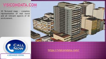
visicomdata.com
3D Textured maps - complete representation of
real world and all relevant aspects of 3D
environment.
https//visicomdata.com/
380442010086
2
Population distribution map is a type of element
which is used for optimization and various types
of wireless network planning. A population
distribution model may include various factors
such as - population density for every cell of
the grid or for each area units.
3
The 3D maps provided by us are an innovative and
alternative to topographic maps and traditional
mountain panoramas. Visicom produces digital 3D
realistic maps for any territory providing
customized solutions for each client. These 3D
maps are created from stereo pairs of
high-resolution, most up-to-date satellite
imagery and very in accuracy and details.
4
Land use data also known as land cover data are
arguably the most vital data for any conservation
project. No matter how delineated from coarse
satellite derived land cover to very detailed
site-specific land use, these data are the
backbone of nearly all projects.
5
Extra-accurate high-resolution 3D City Model
generated as a composition of Digital Terrain
Model and above-ground features such as
buildings, vegetation and engineering
constructions.
6
Contact Information https//visicomdata.com/ Busin
ess Name-PJSC "VISICOM" Email-evgenkr_at_visi.com.ua
Street-25/2 Bolshaya, Zhitomirskaya
Street,Kyiv,Ukraine City-Zhitomirskaya
Street State-Kyiv Country-Ukraine Phone-380442010
086 Zip Code-01001
Recommended
CrystalGraphics Presentations


