
major dams in kurdistan region - PowerPoint PPT Presentation
Title:
major dams in kurdistan region
Description:
major dams in kurdistan region – PowerPoint PPT presentation
Number of Views:78
Title: major dams in kurdistan region
1
Kurdistan Major Dams
Names Zhiyar Muslih Alind Khalid University
of Dohuk,
Abstract
Methods and Materials
Discussion
Kurdistan region . Has suffered sever drought
events in the past two
This study selected in Google Earth, add polygon
to select Kurdistan area. after that working on
study area in ArcMap Platform to do this, the
study area is need to be save as KML format.
And open it on arc map and open Arc toolbox -gt
Conversion tools -gt From KML, KML to layer Ok.
Then add data -gt click add base map -gt Imagery
with Labels. After that click K-Gis-Data select
K_water_areas showing many dams and select click
right on Kurdistan open attribute table. The
other hand creates New data frame to merging K-
region/ Iraq
A
D
In order to The Kurdistan Regional Government is
rich in water resources and composed of
highlands. Khabur, which meets Tigris before
reaching Baghdad, the Great Zab, Little Zab,
Sirwan and Udhaim rivers are significant rivers
in the region.low precipitation in the region
during certain periods leads to drought. Another
reason for building dams is to store water to
use during dry spells. Especially the dry period
between 2001-2004 caused to water shortage in the
region. As for ground waters, they are used for
drinking and agricultural purposes in the
region. Erbil is located in a region that is
richer than other provinces, especially
Sulaymaniyah, in terms of the ground waters.
Sulaymaniyah province has difficulty in meeting
the water need of the population. Dam development
needs and objectives should be formulated
through a participatory process. 2. An assessment
of all options needs to be conducted,
which gives social and environmental impacts the s
ame significance as technical, economic and
financial factors. 3.Outstanding social and
environmental issues from existing dams should
be addressed before new ones are built. 4.As a
result, planners and engineers must concentrate
in using GIS for selection of suitable site for
construction of dam in Kurdistan, since GIS
provides information, required to consider like
topography, geology , tectonic settlements and
the slope.
decades due to decrease in annual
significant precipitation,
water storage by building dams can mitigate
draft impact an assure water supply. This study
was designed to identify and show the major dams
that built in Kurdistan regional government
which are four major dams in different cities of
Kurdistan regional government by using GIS
Arcmap program to show the major dams on the
maps.to show the important strategies of the
dams on the map
E
B
C
F
Introduction
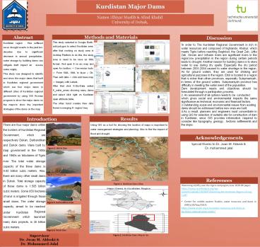
Results
Using GIS as a tool for showing the location of
maps is important to water management strategies
and planning. Also to find the impact of flood
and drought .
There are four major dams within the borders of
Kurdistan Regional
Government, which are respectively Dukan,
Darbandikan and Duhok dams. Were built by
Acknowledgements
Special thanks to Dr. Jwan M. Aldoski Dr.
mohammed jalal
Figure 3. Duhok Dam
Iraqi government in the 1950s and 1960s on
tributaries of Tigris
river The total water storage
capacity of the three dams is 9.85 billion
cubic meters. Also, there are many other small
dams in Duhok. Total storage capacity of those
dams is 1.505 billion cubic meters. Some 850
hectares of land is irrigated through those
small dams. The water storage capacity, aimed
to be reached
Figure 4. Dukan Dam
References
Figure 1. Kurdistan Dams Map.
- Damming in(KRI),save the tigers campagion,June
2020.86 pages https//www.savethetigris.org/wp-
content/uploads/2020/07/Damming-the-Kurdistan-Regi
on-of-Iraq- 1.pdf - .
- Center For middle eastern Studies, water
resources and dams in (KRG),(24/Sep/2013) - https//www.orsam.org.tr/en/water-resources-and-da
ms-in- - kurdistan-regional-government/
Figure 5. Darbandikhan Dam
Regional Government which launched
under Kurdistan
many dam projects, is 38 billion cubic
meters. Figure 6. Mosul Dam
Supervisor Dr. Jwan M. Aldoski Dr. Mohammed
Jalal
Figure 2. Kurdistan Dams Map in Gis.