
Geologic - PowerPoint PPT Presentation
1 / 37
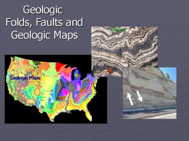
Title: Geologic
1
Geologic Folds, Faults and Geologic Maps
Folding
Geologic Maps
2
- Chapter goals objectives
- Review the three types of stresses.
- Describe the differences between elastic,
brittle, - and ductile deformation.
- Review the differences between stress and
- strain and the influence of temperature on
rocks. - Understand the concept of strike and dip.
- Review various fault and fold terminology.
- Understand the difference between a topographic
- and geologic maps.
- Understand the basic interpretation of geologic
- maps and cross-sectional views.
3
folded and disturbed layers
Undisturbed Layers
4
How is rock deformation discussed?
(stress and strain relationships)
- Stress
- force (pressure) acting on the rock surface
- Strain
- a change in the shape (deformation) to the
- response of stress
Compression
Tensional
undisturbed cube
Shear
5
Types of stresses and strains
Confined Pressure Stress is applied to the
rock uniformially in all directions
Differential Pressure Stress is applied to the
rock in various directions
Uniformly squeezed
Strained in other directions
6
Brittle, Ductile and elastic strain under
differential type stress dependant on rock type
Elastic deformation change is temporary rock
returns back to its original shape
Ductile deformation a permanent (gradual) change
of material caused by flowing or bending
Brittle deformation a permanent change in the
material where it breaks or cracks
7
I
to be stressed
Discuss with a friend
- Define the meaning of stress and strain.
- 2. Define the 3-major types of stresses.
- 3. Describe the differences between
- confining and differential stresses.
- 4. Provide an example that represents
- elastic, brittle and ductile strains.
I will get an A on my exams and quizzes.
8
- Factors that affect how rock deforms
- temperature
- confining pressures
- rate of deformation
- rock composition
9
- Temperature
- What happens to glass when heated?
- What happens to rocks when heated?
Rocks behave brittle at the surface (low
temperatures).
Rocks behave ductile when heated below the
surface (high temperatures).
10
Confining Pressure
Brittle
Low Confining pressure at the surface --- rocks
behave brittle and fracture.
High Confining pressure below the surface,
rocks behave ductile and do not fracture but bend.
Ductile
11
Rate of deformation If rocks are suddenly
subjected to pressure brittle behavior If
rocks are slowly subjected to pressure
ductile behavior
Sudden movements of faulted areas produce sudden
pressure rocks behave brittle and crack /
fracture
Slow deformation over geologic time
produces ductile behavior of rocks. This causes
folding.
12
Composition of rock The mineral content
determines if the rock behaves as brittle or
ductile masses.
Brittleness in Rocks presence of garnet quartz
olivine
Ductileness in Rocks presence of mica calcite
gypsum
Rock types
Rock types
sedimentary / meta rocks limestone, shale,
marble slate
Intrusive / extrusive rocks granites / hard
rocks
13
I
to be stressed.
Discuss with a friend
- What four (4) factors affect how rocks
- undergo deformation?
- When do rocks typically behave
- brittle and ductile under the four factors
- described above?
I will get an A on my exams and quizzes
14
Tectonic environments that allow compression,
shear and tensional type stresses
Convergent boundary compressional stresses
producing subduction zones O-O, O-C, C-C
collisions
Transform boundary Shear type stresses producing
shear zones of strain -
Divergent boundary Tensional type stresses
plates are moving apart
15
Orogen Crust that has been deformed by
continental collision
Craton stable un-deformed crust
tectonically stable
16
Isostasy A floating object automatically adjusts
to a position of equilibrium with the medium in
which it is floating. Think floating ice in
water As the ice melts, it continues to move
upwards in the water to
maintain equilibrium (90 of the ice is below
the water surface). Continents do the same
(Isostatic rebound)
17
I
structural geology.
Discuss with a friend
- Define the type stresses associated with
- convergent, divergent and transform
- plate boundaries.
- 2. What is isostacy how does isostatic
- rebound relate to the earths continents?
I will get an A on my exams and quizzes
18
If you can see this cube rotate, then you can
picture diagrams in 3-D.
19
Structural Geology Structural geologists
decipher earth history by
identifying and mapping deformational structures.
Why understand structural geology? Decipher
geologic history by looking at the subsurface
Look for oil resources Look for mining
resources Monitoring groundwater flow
20
How does a geologist measure the orientation of
rock layers and use these measurements to
predict the geologic structure below the earths
surface?
Strike and dip
Strike The compass orientation of the line of
intersection between the a horizontal plane and
a planer feature (a rock layer) Dip The angle
between a tilted surface and a horizontal plane
21
- Measuring the strike of strata
- represents the intersection of the tilted layer
and - the imaginary horizontal plane
- A MAP symbol showing the directional trend
- of strata
Measuring the directional trend
North
45
Map symbol
315
0
imaginary plane
E
W
90
270
180
135
225
S
Strike is 45 degrees
22
How would you plot the strike of these rock
layers
North
Geologic Maps
Strike represents the MAP orientation
and general direction of strata
23
- Measuring the dip angle with respect to strike of
- strata
- represents the ANGLE (tilt) of strata in
- reference to the imaginary horizontal plane
- Dip is ALWAYS PERPENDICULAR to strike
Strike and dip map symbols
Imaginary plane
12
20
15
Dip angle
0-90o
47
62
24
I
Love strike and dip
- 1. Define strike and dip
- 2. What is strike and dip used for
- 3. Draw the strike and dip symbol and state
- what the symbol represents
Discuss with a friend
I will get an A on my exams and quizzes
25
Interpreting folds
Map Symbols
oldest
Young
Anticline fold
Syncline fold
Youngest rocks in the middle
Oldest rocks in the middle
26
Faults
Joint fracture within a rock body Fault
movement along a fracture or joint
fault
B
Joint
B
A
A
27
Determining the type of fault using the
hanging-wall (HW) and foot-wall (FW)
- Normal Fault
- HW down relative to FW
- Tensional stress
FW
HW
FW
HW
HW
- Reverse Fault
- HW up relative to FW
- Compression stress
FW
28
Vertical type faults
Compression
Tensional
FW
HW
FW
HW
Normal faulting
Reverse faulting
FW
HW
FW
HW
29
Horizontal faulting two blocks sliding past one
another
Map View
Turned to Right
Turned to Left
30
What type of strike-slip fault?
Right-lateral strike slip
31
- Normal Fault
- hanging wall DOWN relative to footwall
- tensional forces (pulling apart)
- extension of crust (crust grows)
- Reverse Fault
- hanging wall UP relative to footwall
- compressional forces (pushing together)
- shorting of crust (crust shrinks)
- Strike-Slip fault
- horizontal movement (sliding past)
- moves rocks along a horizontal plane
32
I
structural geology.
- Draw a picture of an anticline and syncline
- and show the strike / dip symbols
- 2. Draw a diagram showing a normal and
- reverse fault (label all the parts)
- 3. What is lateral strike-slip fault
- 4. How can you tell the difference between
- a left and right lateral strike slip fault
I will get an A on my exams and quizzes
33
Geologic Map of the USA
Introduction to Geologic Maps
34
- What is a Geologic Map??
- Surface distribution of rock types
- represented on a 2-dimentional map
What a geologic map tells you
- Rock age relationships
- Types of rocks present
- Geologic structures
- Geologic prospecting
- Oil, gas, minerals
- Geologic hazards
35
Interpretation of structural features on a
Geologic Map
B
D
D
C
C
Anticline
How would the surface be expressed ?
How would the strike/dip symbol be represented
What type of fold is indicated in the diagram
36
Construction of a geologic cross-section
Interpretation of geologic structures below the
surface (sub-surface geology)
37
youngest
Qv
A
Kw
Jd
23
35
Kw
Qv
Du
Jd
A
60
Pc
Se
Se
Du
A
A
Pc
Oldest
Geologic cross-section
Recommended
CrystalGraphics Presentations


