Ecological Forecasting PowerPoint PPT Presentation
Title: Ecological Forecasting
1
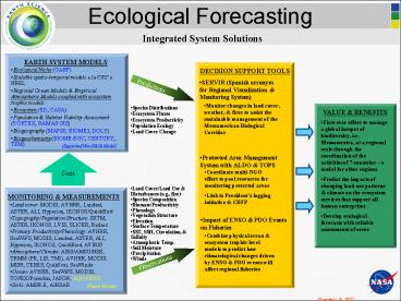
Ecological Forecasting
- Ecological Niche (GARP)
- Scalable spatio-temporal models a la CSUs NREL
- Regional Ocean Models Empirical Atmospheric
Models coupled with ecosystem trophic models - Ecosystem (ED, CASA)
- Population Habitat Viability Assessment
(VORTEX, RAMAS GIS) - Biogeography (MAPSS, BIOME3, DOLY)
- Biogeochemistry (BIOME-BGC, CENTURY, TEM)
- SERVIR (Spanish acronym for Regional
Visualization Monitoring System)
- Monitor changes in land cover, weather, fires
to assist the sustainable management of the
Mesoamerican Biological Corridor
- Species Distributions
- Ecosystem Fluxes
- Ecosystem Productivity
- Population Ecology
- Land Cover Change
- First-ever effort to manage a global hotspot of
biodiversity, i.e. Mesoamerica, at a regional
scale through the coordination of the activities
of 7 countries a model for other regions - Predict the impacts of changing land-use patterns
climate on the ecosystem services that support
all human enterprises - Develop ecological forecasts with reliable
assessments of error
(Supported Non-NASA Model)
- Protected Area Management System with ALDO TOPS
- Coordinate multi-NGO effort to pool resources for
monitoring protected areas - Link to Presidents logging initiative CBFP
- Land Cover/Land Use Disturbances (e.g., fire)
- Species Composition
- Biomass/Productivity
- Phenology
- Vegetation Structure
- Elevation
- Surface Temperature
- SST, SSH, Circulation, Salinity
- Atmospheric Temp.
- Soil Moisture
- Precipitation
- Winds
- Land cover MODIS, AVHRR, Landsat, ASTER, ALI,
Hyperion, IKONOS/QuickBird - Topography/Vegetation Structure SRTM, ASTER,
IKONOS, LVIS, SLICER, Radars - Primary Productivity/Phenology AVHRR, SeaWiFS,
MODIS, Landsat, ASTER, ALI, Hyperion, IKONOS,
QuickBird, AVIRIS - Atmosphere/Climate AIRS/AMSU/HSB, TRMM (PR, LIS,
TMI), AVHRR, MODIS, MISR, CERES, QuikScat,
SeaWinds - Ocean AVHRR, SeaWiFS, MODIS, TOPEX/Poseidon,
JASON, AQUARIUS - Soils AMSR-E, AIRSAR
- Impact of ENSO PDO Events on Fisheries
- Combine physical ocean ecosystem trophic-level
models to predict how climatological changes
driven by ENSO PDO events will affect regional
fisheries
(Future Mission)
November 10, 2003
PowerShow.com is a leading presentation sharing website. It has millions of presentations already uploaded and available with 1,000s more being uploaded by its users every day. Whatever your area of interest, here you’ll be able to find and view presentations you’ll love and possibly download. And, best of all, it is completely free and easy to use.
You might even have a presentation you’d like to share with others. If so, just upload it to PowerShow.com. We’ll convert it to an HTML5 slideshow that includes all the media types you’ve already added: audio, video, music, pictures, animations and transition effects. Then you can share it with your target audience as well as PowerShow.com’s millions of monthly visitors. And, again, it’s all free.
About the Developers
PowerShow.com is brought to you by CrystalGraphics, the award-winning developer and market-leading publisher of rich-media enhancement products for presentations. Our product offerings include millions of PowerPoint templates, diagrams, animated 3D characters and more.

