
Presentazione di PowerPoint PowerPoint PPT Presentation
1 / 4
Title: Presentazione di PowerPoint
1
EURAINSAT European Satellite Rainfall
Monitoring at the Geostationary Scale European
Commission Directorate General XII Science,
Research and Development Fifth Framework RTD
activities of a generic nature Environment and
Sustainable Development sub-programme
2
Problem Rainfall represents an important
component of everyday weather and is a
troublesome issue for weather forecasting at all
spatial and temporal scales. Quantitative data
rely upon the use of rain gauges and weather
radar networks however, only very limited
portions of most continents are covered by such
networks and their effective use is hindered by a
number of calibration and maintenance problems.
Furthermore, radar and gauge data are
exceptionally rare over ocean areas. Thus,
satellite rainfall estimation has become a
necessity for obtaining measurements from the
mesoscale (local area) up to the global Earth
coverage. Science is at work for the production
of new satellite rainfall algorithms that make
use of the coming generation of satellite sensors
(e.g. SEVIRI on board METEOSAT Second Generation,
MSG) whose advanced data sets will enhance the
amount of physical information on clouds and
precipitation systems. Proper attention to the
problem of satellite rainfall analyses for better
initialization of numerical weather prediction
(NWP) models will lead to improved forecasts at
all scales. Benefits are manifold among others
1.More precise mesoscale and global scale
weather forecasts 2.Better monitoring of
severe weather phenomena (e.g. flash floods,
storm-scale events,...) 3.Support to
hydrology and water management 4.Support to
decision making in civil protection.
3
Scientific objectives and approach The key
objective of EURAINSAT is the development of
algorithms for rapid-update of satellite rainfall
estimations at the geostationary scale. The new
channels available with the SEVIRI radiometer in
the visible (VIS) and infrared (IR) portion of
the spectrum will provide much better insight
into the microphysical and dynamic structure of
precipitating clouds thus allowing for a more
precise identification of precipitation
intensities. Microwave (MW) radiometers on board
polar orbiting satellites will be used to
determine information on the vertical structure
of clouds. The method(s) will work as follows 1.
Microphysical characterization of precipitating
clouds with VIS/IR sensors 2. Creation of cloud
microphysical and radiative databases from cloud
model outputs and aircraft penetrations 3.
Tuning of MW algorithms for different cloud
systems (convective, stratiform, maritime,
continental,...) 4. Combination of data from the
different algorithms and application to a rapid
update cycle at the geostationary scale.
Expected impacts The consortium wants to 1.
solve the basic scientific problem of obtaining
realistic physical and quantitative satellite
rainfall estimations using the new sensors that
will be soon available on MSG and other
satellites 2. provide a rainfall product that
improves rainfall monitoring and is ready as an
input to the latest generation of local area
and global circulation NWP models. End-users
include international organizations that have
responsibilities for weather analysis and
forecasting, the World Meteorological
Organization (e.g. impacts in remote or
insufficiently monitored areas, like Africa), the
Food and Agriculture Organization (FAO) of the UN
(food production monitoring especially in
developing countries), satellite exploitation
organizations, weather forecasting offices at the
national and regional scale, civil protection
agencies. The European Union will benefit from
additional powerful support to decision making
authorities of its member states, as well as
coverage of the whole of Europe every 15 minutes.
Updates at 15 minute intervals will have a direct
impact on the monitoring of severe events in
hazardous areas and is of fundamental importance
to this activity. Algorithms will be made
available to relevant agencies as a result of the
project.
20 September 1999, 0000 UTC. 24 h forecast of
total precipitation (mm) over the previous 24 h
from the Limited Area Model BOLAM. Forecast
during the Mesoscale Alpine Programme (MAP)
Intensive Observation Period 2 (IOP 2). Model run
provided by Andrea Buzzi, ISAC-CNR, Bologna, Italy
4 November 1966, 2300 UTC. Model RAMS run of the
Florence flood event. Colors ice clouds (cyan),
water clouds (gray), precipitation (violet).
Model run provided by Francesco Meneguzzo,
Massimilano Pasqui and Gianni Messeri, FMA and
IB-CNR, Firenze, Italy
4
Principal Investigators World Wide
Web Vincenzo Levizzani, ISAC-CNR, Bologna,
Italy http//www.isac.cnr.it Alberto Mugnai,
ISAC-CNR, Roma, Italy gtgt Andrea Buzzi, ISAC-CNR,
Bologna, Italy gtgt Francesco Tampieri, ISAC-CNR,
Bologna, Italy gtgt Francesco Meneguzzo, FMA and
IB-CNR, Firenze, Italy http//www-fma.iata.fi.cnr.
it/ Franco Prodi, Univ. Ferrara, Ferrara,
Italy http//www.fe.infn.it/dipfis.html Frank S.
Marzano, Univ. LAquila, LAquila,
Italy http//www.diel.univaq.it/ Martina
Kästner, DLR, Weßling, Germany http//www.dfd.dlr
.de/ Daniel Rosenfeld, Hebrew Univ., Jerusalem,
Israel http//earth.es.huji.ac.il/machon/ Chris
Kidd, Univ. Birmingham, Edgbaston,
UK http//www.ges.bham.ac.uk/
Steering Committee Michel Schouppe, EC,
Brussels, Belgium Donald E. Hinsman, WMO, Geneva,
Switzerland Peter Bauer, ECMWF, Reading,
UK Johannes Schmetz, EUMETSAT, Darmstadt,
Germany J. Pedro V. Poiares Baptista, ESA-ESTEC,
Nordwijk, The Netherlands Eric A. Smith,
NASA-GSFC, Greenbelt, MD, USA Gilberto A.
Vicente, NASA-GSFC, DAAC, Greenbelt, MD,
USA James F. W. Purdom, CIRA, Colorado State
Univ., Ft. Collins, CO, USA F. Joseph Turk, NRL,
Marine Meteorology Division, Monterey, CA,
USA
European Commission Information EURAINSAT is a a
shared-cost project (contract EVG1-2000-00030)
co-funded by the Research DG of the European
Commission within the RTD activities of a generic
nature of the Environment and Sustainable
Development sub-programme (5th Framework
Programme). The Commission contact person for
this project is Dr. Michel Schouppe, Research DG
"Biodiversity and Global Change" Unit (DI-1),
Square de Meeûs, 8 (SDME 4/71), B-1050 Brussels
BELGIUM Phone 32 2 296.06.18, Fax 32 2
296.05.88, E-mail michel.schouppe_at_cec.eu.int
- Further Information about EURAINSAT
- Web server http//www.isao.bo.cnr.it/eurainsat/
- Or contact the EURAINSAT co-ordinator Dr.
Vincenzo Levizzani - ISAC-CNR, via Gobetti 101, I-40129 Bologna,
Italy - Phone (39) 051-6399578 Fax (39) 051-6399649
e-mail v.levizzani_at_isac.cnr.it
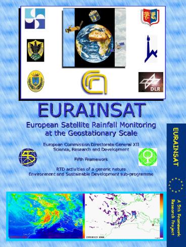
Front cover figure 19 September 1999, 0900 UTC.
Frontal passage during the Mesoscale Alpine
Programme (MAP) Intensive Observation Period 2
(IOP 2). Left METEOSAT-7 IR brightness
temperature (K). Right Satellite rainfall
estimation obtained using the hybrid
microwave-infrared technique of J. F. Turk (NRL,
Monterey). Satellite data were gathered by
METEOSAT-7 and the DMSP SSM/I. Images provided by
Roberta Amorati, ISAC-CNR, Bologna. Edited by
Vincenzo Levizzani on behalf of the EURAINSAT
Consortium, 1 February 2002. The authors and the
consortium accept no responsibility for the use
of information contained in the present brochure.
Recommended
