Earth Origins Jeopardy - PowerPoint PPT Presentation
Title:
Earth Origins Jeopardy
Description:
Mercator projection. To Board. Map Projections 300. polar regions ... What geometric shape is a Mercator projection based on? To Board. a cylinder. Map Projections 600 ... – PowerPoint PPT presentation
Number of Views:97
Avg rating:3.0/5.0
Title: Earth Origins Jeopardy
1
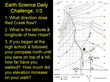
Earth Science Daily Challenge, 1/3
- 1. What direction does Red Creek flow?2. What
is the latitude longitude of New Hope?3. If
you began at the high school followed your
compass north until you were on top of a hill,
how far have you walked? How much did you
elevation increase on your walk?
2
MAPPING UNIT JEOPARDY
Earths Surface Parts of a Map Map Projections Latitude - Longitude Name that Cont/Ocean
100 100 100 100 100
200 200 200 200 200
300 300 300 300 300
400 400 400 400 400
500 500 500 500 500
600 600 600 600 600
3
Earths Surface 100
- What makes up the earths biosphere?
all living things
To Board
4
Earths Surface 200
- What kind of landform region has low relief and
may be coastal or interior in nature?
plains
To Board
5
Earths Surface 300
- Which of earths spheres consists of all the
water on earth?
hydrosphere
To Board
6
Earths Surface 400
- What kind of landform region has low relief and
high elevation?
plateaus
To Board
7
Earths Surface 500
- What term means shape of the land and depends
on elevation, relief, landforms?
topography
To Board
8
Earths Surface 600
- Which of earths spheres consists of all the
solid rocks, sediments, and soils on earth?
lithosphere
To Board
9
Parts of a Map 100
- What is shown by a maps compass rose? (This is a
term for north, south, east, and west.)
cardinal directions
To Board
10
Parts of a Map 200
- What part of a map explains what the symbols on
the map mean?
key or legend
To Board
11
Parts of a Map 300
- What part of a map shows how distances on a map
compare to distances in the real world?
map scale
To Board
12
Parts of a Map 400
- What is the name of the direction that is the
same as a bearing of 225?
southwest
To Board
13
Parts of a Map 500
- If 1 inch on the map equals 50 miles in the real
world, how far apart are two cities that are 5 ½
inches apart on the map?
275 miles
To Board
14
Parts of a Map 600
- If you are walking directly ENE and then take a
sharp left, what is your bearing (in degrees)?
337.5
To Board
15
Map Projections 100
- What is the most accurate model of the earth?
a globe
To Board
16
Map Projections 200
- What kind of map projection shows lines of
latitude and longitude all straight and meeting
at 90 angles?
Mercator projection
To Board
17
Map Projections 300
What parts or the world are most accurately shown
with a map based on an azimuthal projection?
polar regions
To Board
18
Map Projections 400
What kind of map projection most accurately
portrays the mid-latitudes?
conic projection
To Board
19
Map Projections 500
- What geometric shape is a Mercator projection
based on?
a cylinder
To Board
20
Map Projections 600
- What is distorted on a Robinson projection?
everything is distorted a little shapes and
areas
To Board
21
Latitude - Longitude 100
- What line of latitude divides the northern and
southern hemispheres?
equator
To Board
22
Latitude - Longitude 200
- What city is the basis of the Prime Meridian?
Grenwhich, England
To Board
23
Latitude - Longitude 300
- What is another term for the lines of latitude on
earth?
parallels
To Board
24
Latitude - Longitude 400
- These lines on the earth are all the same length
and meet at the north and south poles? (This is
another tem for longitude.)
meridians
To Board
25
Latitude - Longitude 500
- What is the name of the 180E or 180W longitude
line?
International Date Line
To Board
26
Latitude - Longitude 600
- What is the latitude and longitude of a point on
earth directly opposite of 27N, 80E
27S, 100W
To Board
27
Name that Continent or Ocean 100
- What continent or ocean is found at 10N, 30E ?
Africa
To Board
28
Name that Continent or Ocean 200
- What continent or ocean is found at 35N, 100W
?
North America
To Board
29
Name that Continent or Ocean 300
- What continent or ocean is found at 80N, 40E ?
Arctic Ocean
To Board
30
Name that Continent or Ocean 400
- What continent or ocean is found at 25S, 140E
?
Australia
To Board
31
Name that Continent or Ocean 500
What continent or ocean is found at 85S, 90W ?
Antarctica
To Board
32
Name that Continent or Ocean 600
What continent or ocean is found at 10S, 60E ?
Indian Ocean
To Board


