
Maps adapted from www.rivercenter.uga.edu and www.garivers.org PowerPoint PPT Presentation
1 / 1
Title: Maps adapted from www.rivercenter.uga.edu and www.garivers.org
1
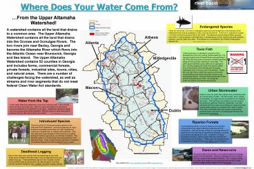
Where Does Your Water Come From?
From the Upper Altamaha Watershed! A watershed
contains all the land that drains to a common
area. The Upper Altamaha Watershed contains all
the land that drains into the Oconee and Ocmulgee
Rivers. The two rivers join near Baxley, Georgia
and become the Altamaha River which flows into
the Atlantic Ocean near Brunswick, Georgia and
Sea Island. The Upper Altamaha Watershed
contains 52 counties in Georgia and includes
farms, commercial forests, private forests,
industrial sites, towns, cities, and natural
areas. There are a number of challenges facing
the watershed, as well as streams and river
segments that do not meet federal Clean Water Act
standards.
Dams and Reservoirs Dams and reservoirs provide a
more assured water and energy supply to local
residents. However, stopping the rivers natural
flow can cause environmental problems. Fish,
mussels, plants, and other biota depend on the
seasonal rise and fall of water levels to trigger
certain stages of their life cycles. Photo
Source David Shiver, http//www.mindspring.com/s
upertec/PicDay.htm
Maps adapted from www.rivercenter.uga.edu and
www.garivers.org
This project is made possible by US EPA Clean
Water Act 319 program funds, administered by the
Georgia Environmental Protection Division,
Non-Point Source Program. For more information
contact the project director of the UGA River
Basin Centers Initiative for Watershed
Excellence Upper Altamaha Pilot Project at
christine.rodick_at_gmail.com
Recommended
