
Performance - PowerPoint PPT Presentation
1 / 17
Title:
Performance
Description:
... gradiometer in space. an ambient temperature, capacitive gradiometer ... the gradiometer accelerometers and GPS receiver are based on European technology ... – PowerPoint PPT presentation
Number of Views:36
Avg rating:3.0/5.0
Title: Performance
1
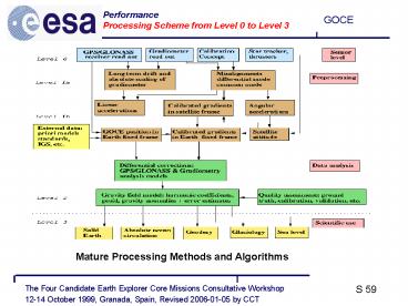
Performance Processing Scheme from Level 0 to
Level 3
Mature Processing Methods and Algorithms
2
Performance Simulation Input
3
Performance End-to-End Simulation Scheme
4
Performance Four Error Classes
instrument errors satellite errors instrument/sa
tellite coupling errors post processing errors
5
Performance The 4 Error Classes Simulated Results
Instrument Error
Coupling Error
Satellite Error
Post-Flight Error
this total error is used in the geoid and
gravity field retrievals
Total Error
6
Performance Spherical Harmonic Error Spectrum
7
Performance Spectral Error Results
1 cm geoid and 1 mgal gravity field accuracies
are well recovered at wavelength of 100 km
(degree and order 200)
8
Performance Spatial Error Results
1 cm geoid and 1 mgal gravity field accuracies
are well recovered at wavelength of 100 km
(degree and order 200) for all latitudes except
near the poles.
9
Performance Science Requirements Summary
10
Performance Simulation Results
1
10
the simulated results suggest excellent
performance versus scientific requirements
11
Performance Solid Earth Physics
12
Performance Oceanography
13
Performance Geodesy
14
Conclusions Uniqueness and Complementarity
- GOCE will be the first gravity gradiometer in
space - an ambient temperature, capacitive gradiometer
instrument is selected in combination with GPS
high-low tracking - GOCE will map the Earths gravity field in three
dimensions providing a - - geoid error lt 1 cm at 100 km spatial
resolution - - gravity field error ltlt 1 mgal at 100 km
spatial resolution - The GOCE data will complement data from
altimetric missions, Oersted, CHAMP, GRACE,
ICESAT and Cryosat
15
Conclusions Advancement of European E.O.
capabilities
- the gradiometer accelerometers and GPS receiver
are based on European technology - the drag free system technology offers new
opportunities in a wide range of applications
including E.O. from low orbit altitude - a multi-disciplinary user community within fields
of Solid Earth Physics, Geodesy and Oceanography
is well prepared to utilize the new and accurate
gravity field and geoid data at high spatial
resolution
16
Conclusions Feasibility and Level of Maturity
- all technologies have been demonstrated (except
micro-thrusters) - and the development schedule is acceptable
- an end-to-end and closed loop simulator
provides realistic - and comprehensive insight into system
performance from - the sensor level to the retrievals of the
gravity field and - geoid signals
- the processing schemes (from Level 0 to Level
3) and - algorithm maturity are meeting the requirements
- impact studies show very promising results for
applications - in the disciplines of solid Earth physics,
absolute ocean - circulation and geodesy
17
Conclusions Timeliness and Programmatics
- the GOCE Mission is very timely in the context
of the user - needs and their associated readiness
- no implementation constraints exist
- the proposed launch in 2004 is in the low
activity region of - the solar cycle)
- the expected launch in late 2006 still
OK.
Recommended
CrystalGraphics Presentations


