
Rutgers Satellite Imagery PowerPoint PPT Presentation
1 / 4
Title: Rutgers Satellite Imagery
1
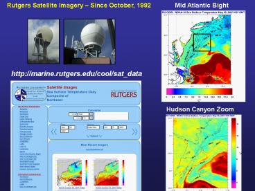
Rutgers Satellite Imagery Since October, 1992
Mid Atlantic Bight
http//marine.rutgers.edu/cool/sat_data
Hudson Canyon Zoom
2
Rutgers Website Usage Tracked since 1995
Hourly Usage 99 External
May 2006 daily averages 406,471 hits 255,608
files 22,009 pages 6,322 visits.
Automatic Satellite Data Backup with U. Maine
SST Regions of Interest
3
Rutgers Underwater Gliders Since October, 2003
Temperature
http//marine.rutgers.edu/cool/auvs
Salinity
Backscatter
4
Coordination with NOAA Fisheries Programs
Monthly Supplemental Finfish Surveys
Fish Tracking Receivers on Gliders
Glider Outbound
Glider Inbound
Recommended
