
Daily BRDF/Albedo Algorithm for MODIS Direct Broadcast Sites PowerPoint PPT Presentation
1 / 1
Title: Daily BRDF/Albedo Algorithm for MODIS Direct Broadcast Sites
1
Daily BRDF/Albedo Algorithm for MODIS Direct
Broadcast Sites
Crystal Schaaf(1), Alan Strahler(1), Curtis
Woodcock(1), Yanmin Shuai(1), Jicheng Liu(1),
Ziti Jiao(1), Qingling Zhang(1), John Hodges(1),
Jonathan Salomon(1), Xiaowen Li(1,2,3), Jindi
Wang(3), David Roy(4), Ian Grant(5), David
Jupp(6), Phillip Frost(7), Tom Bobbe(8), Robert
Wolfe(9)
(1) Department of Geography and Center for Remote
Sensing, Boston University, Boston, MA 02215,
USA (2) Institute of Remote Sensing
Applications/CAS (3) Beijing Normal University
(4) South Dakota State University (5)
Commonwealth Bureau of Meterology (6) CSIRO (7)
Council for Scientific and Industrial Research
(CSIR) Satellite Application Centre (SAC) (8)
USDA Forest Service Remote Sensing Applications
Center (RSAC) (9) Goddard Space Flight Center
The initial implementation over sites in China
(Institute of Remote Sensing Applications) will
be followed by sites in Australia (CSIRO and the
Bureau of Meteorology), South Africa (Council for
Scientific and Industrial Research Satellite
Application Centre), and the USA (USDA Forest
Service Remote Sensing Applications Center,
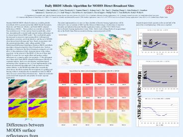
Utah). Below, daily rolling albedos of an
agricultural site on the North China Plain are
monitored during a senescent period in 2004.
Standard MODIS BRDF/Albedo Products are available
globally from March 2000 to present and include
BRDF Model Parameters, Black-sky and White-sky
Albedos, and Nadir BRDF-Adjusted Reflectances
(NBAR). These products are currently provided
at a 1km resolution every 16 days and are based
on multi-date, cloud-free, atmospherically-correct
ed multi-spectral surface reflectances fit to a
linear kernel-driven BRDF model. The overall
global quality has increased in successive
reprocessing efforts with improved atmospheric
correction, and cloud detection and the use of
MODIS observations from both Aqua and Terra.
Based on experience with this operational
algorithm, a daily rolling, gridded, 500m
Bidirectional Reflectance Distribution Function
(BRDF) and albedo algorithm is being developed
for Direct Broadcast sites. Such an algorithm is
of interest to the Direct Broadcast community as
it will allow (1) the production of daily
characterizations of the surface anisotropy via
the retrieval of the BRDF, (2) the use of these
daily BRDFs to correct for view angle effects and
produce surface reflectances at a common,
nadir-view geometry (3) the subsequent use of
these daily Nadir BRDF-Adjusted Reflectances
(NBAR) for vegetation indexes, land cover
classification, and phenological monitoring of
the vegetation cycle (4) local implementation of
the burned area detection algorithm and (5) the
production of daily surface albedos. As the MODIS
algorithm relies on multi-day observations, the
efforts includes the development of a gridding
and binning routine to standardize the
accumulation of data for BRDF retrieval across
various Direct Broadcast sites. Retrieval
constraints can be tuned both temporally and
spatially for timely regional applications.
Despite frequent cloudy episodes in the second
half of the period, the overall phenology of the
area is captured.
Red BSA
Pixel 1656, 1591
NIR BSA
NIR (0.10-0.45) Red (0.0-0.1) Green (0.0-0.15)
0.0 0.3
0.0 0.3
(NIR-Red)/(NIRRed)
0.0 1.0
Differences between MODIS surface reflectances
from adjoining swaths (upper left) and MODIS NBAR
(upper right) over the Great Lakes/NYarea, 6 Sep
2000. Swath effects can still be seen in
conventional NDVI computation (lower left), but
have been removed in the NBAR-NDVI (lower right).
Recommended
