Satellite Network PowerPoint PPT Presentation
Title: Satellite Network
1
Satellite Network
2
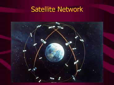
Satellite Network
- 24 satellites in orbit, plus 3 backups
- 3000-4000 lbs, solar powered
- Orbit height is roughly 20,000 km (Earth radius
is 6400 km) - Complete orbit twice per day
- At any point on Earth, at least four should be
visible at any time
3
Finding Location
- Based on principle of triangulation or
trilateration - E.g. in two dimensions, three overlapping
circles is enough to find a precise point - In 3 dimensions, three spheres overlap in a
single point - Minimum you need two satellites and the Earths
surface
4
Distance calculation
- Satellites send out low-power, high frequency
radio signals with time stamps - Time stamps come from long sequences of
pseudo-random numbers that restart each day at
midnight - Satellites have extremely accurate atomic clocks
5
Distance calculation
- Receivers have normal quartz clocks not
accurate enough for this - Quartz clocks are calibrated by using four
satellites for measurements - Travel time can be calculated from delay, because
speed is known (300,000 km per second)
6
Possible Problems
- Waves travel through atmosphere this changes
speed of light - Orbits can change due to moon/sun gravity (DoD
monitors and includes corrections in signal) - Reflections off of ground stuff
- Bad position data from satellite foils almanac
plan
7
Differential GPS
- Use a base station to improve accuracy
- Fixes some systematic inaccuracies, because the
position of base station is known, and offsets
can be calculated
8
Accuracy
- Hand-held horizontal accuracy of 10-20 meters,
worse for elevations - Differential submeter accuracy, but calculation
is difficult and not real-time - In May 2000, military ended the practice of
including errors in the signals, which used to
limit accuracy to 100m for non-military GPS units.
9
Horizontal ErrorDavid Wilsons GPS Accuracy Page
(URL next slide)
10
Vertical Errorhttp//users.erols.com/dlwilson/gps
vert.htm
PowerShow.com is a leading presentation sharing website. It has millions of presentations already uploaded and available with 1,000s more being uploaded by its users every day. Whatever your area of interest, here you’ll be able to find and view presentations you’ll love and possibly download. And, best of all, it is completely free and easy to use.
You might even have a presentation you’d like to share with others. If so, just upload it to PowerShow.com. We’ll convert it to an HTML5 slideshow that includes all the media types you’ve already added: audio, video, music, pictures, animations and transition effects. Then you can share it with your target audience as well as PowerShow.com’s millions of monthly visitors. And, again, it’s all free.
About the Developers
PowerShow.com is brought to you by CrystalGraphics, the award-winning developer and market-leading publisher of rich-media enhancement products for presentations. Our product offerings include millions of PowerPoint templates, diagrams, animated 3D characters and more.

