
IEEE IROS2013 Digest Template PowerPoint PPT Presentation
Title: IEEE IROS2013 Digest Template
1
Air-Ground Localization and Map
Augmentation Using Monocular Dense Reconstruction
Christian Forster, Matia Pizzoli, Davide
Scaramuzza Robotics and Perception Group,
University of Zurich, Switzerland
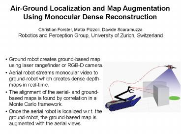
- Ground robot creates ground-based map using laser
rangefinder or RGB-D camera. - Aerial robot streams monocular video to
ground-robot which creates dense depth-maps in
real-time. - The alignment of the aerial- and ground-based
maps is found by correlation in a Monte Carlo
framework. - Once the aerial robot is localized w.r.t. the
ground-robot, the ground-based map is augmented
with the aerial views.
Recommended
