
NOTICES - PowerPoint PPT Presentation
Title:
NOTICES
Description:
NOTICES – PowerPoint PPT presentation
Number of Views:3783
Avg rating:3.0/5.0
Title: NOTICES
1
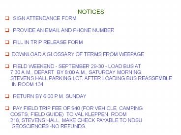
- NOTICES
- SIGN ATTENDANCE FORM
- PROVIDE AN EMAIL AND PHONE NUMBER
- FILL IN TRIP RELEASE FORM
- DOWNLOAD A GLOSSARY OF TERMS FROM WEBPAGE
- FIELD WEEKEND - SEPTEMBER 29-30 - LOAD BUS AT
- 730 A.M., DEPART BY 800 A.M., SATURDAY
MORNING, - STEVENS HALL PARKING LOT. AFTER LOADING BUS
REASSEMBLE IN ROOM 134 - RETURN BY 600 P.M. SUNDAY
- PAY FIELD TRIP FEE OF 40 (FOR VEHICLE, CAMPING
- COSTS, FIELD GUIDE) TO VAL KLEPPEN, ROOM
- 218, STEVENS HALL. MAKE CHECK PAYABLE TO NDSU
GEOSCIENCES -NO REFUNDS.
2
GETTING READY
- Personal change of clothing warm jacket, hat,
gloves, - sun glasses sun screen lip gloss
headlamp/flashlight digital - camera
- Mealsfood for dinner/breakfast/bag lunches (1
breakfast, - 1 lunch, 1 dinner) Sunday lunch in Fort
Ransom. - Camping tent/ground sheet or tent space
arranged - sleeping bag and pad.
- Day pack water bottlecamera and film field
- notebook / pencils rock hammer (borrow from
- Department) safety glasses.
IMPORTANT EVERYTHING YOU NEED FOR THE DAY
SHOULD BE WORN OR IN YOUR DAY PACK. ONCE THE BUS
IS LOADED YOU WILL NOT BE ABLE TO GET TO YOUR BAG
UNTIL THE EVENING
3
(No Transcript)
4
Geological cross-section of eastern North Dakota
Sheyenne meltwater trench
Moraines
Moraines
Lake Agassiz beds
Glacial drift
Pierre Formation
PreCambrian metamorphic rocks
Niobrara Formation
5
(No Transcript)
6
Flatness prevails in the the Red River lowland
7
Fargo landfill on 45th Street West and 12 Avenue
North exposes the deposits of Lake
Agassiz
8
The laminated silts of the Sherack Formation The
upper 20 feet of Lake Agassiz sediments
9
Outline 64
Lake Agassiz sediments are structurally weak and
pose a special problem to construction in the F-M
area. All large buildings, the Radisson
Hotel, the FM Dome, high rise dorms at
NDSU, etc., require additional support
Caissons
95feet
200 ft
Precambrian igneous and metamorphic rocks
10
Geology 304 Lesson 3
Land forms and types of deposits associated with
Lake Agassiz
A. Ashworth
11
The most obvious of the beaches was named
after the town of Campbell, Minnesota, by
Warren Upham who gave the lake its
distinguished name in 1895
12
The position of the Laurentide Ice Sheet at
10,000 years ago. In eastern North Dakota, Lake
Agassiz extends along the North Dakota-Minnesota
border. Glacial ice still remains buried in the
till in the Missouri Coteau region (Bajc et al.,
2000).
13
Lake Superior
Ouimet Canyon, east of Thunder Bay,
Ontario. Deep canyon was probably eroded during
a catastrophic discharge of Lake Agassiz. The
water flowed towards Lake Superior and
then through the Great Lakes and the St.
Lawrence Seaway to the North Atlantic Ocean
14
Outline 68
15
Fossils from Lake Agassiz deposits
Fossils from Trollwood Park that come from 25
feet depth. Radiocarbon dated at 10, 230 years.
Indicate that Lake Agassiz drained. The
mollusc, insects, and plant fossils indicate a
climate like northern Minnesota
16
25 cm
Molar tooth of a woolly mammoth Mammuthus
primigenius from sand and gravel deposits of the
Herman standline at Embden, North Dakota
17
What the Emden Interchange on I 94 might have
looked like 11,000 years ago. Woolly
Mammoth (Mammuthus primigeneus) on the shore of
Lake Agassiz
18
(No Transcript)
19
(No Transcript)
20
Vegetation changes in Barnes County, North
Dakota, during the last 12,000 years
- Spruce Forest
- 12,000 10,000 cal yr B.P
- Spruce - Birch Forest
- 10,000 9000 yr B.P
- Deciduous Forest
- 9000 8000 cal yr B.P.
- Weedy Prairie
- 8000 4000 cal yr B.P.
- Grass Prairie
- 4000 cal yr B.P. - present
Recommended
CrystalGraphics Presentations


