
Atmosphere and Ocean Circulation - PowerPoint PPT Presentation
1 / 27
Title:
Atmosphere and Ocean Circulation
Description:
Atmosphere and Ocean Circulation. Carrie Manfrino. Density of air is controlled by ... Air pressure is the weight of the air from Earth's surface to the top of the ... – PowerPoint PPT presentation
Number of Views:146
Avg rating:3.0/5.0
Title: Atmosphere and Ocean Circulation
1
Atmosphere and Ocean Circulation
- Carrie Manfrino
2
Density of air is controlled by temperature,
pressure and moisture content.
6-1
Atmospheric Processes
- Warm air is less dense than cold air and moist
air is less dense than dry air. - Air pressure is the weight of the air from
Earths surface to the top of the atmosphere and
equals 1.04kg/cm2 (standard air pressure, one
atmosphere) at sea level. - Low pressure zone is where air density is lower
than in surrounding areas because the air is
warmer or has a higher moisture content. - High pressure zone is where air pressure is
higher than in surrounding area because of
cooling or lower moisture content.
3
Heating and Cooling of Air
4
6-1
Atmospheric Processes
- Fluids (air and water) flow from areas of high
pressure to areas of low pressure. - Change in pressure across a horizontal distance
is a pressure gradient. - Greater the difference in pressure and the
shorter the distance between them, the steeper
the pressure gradient and the stronger the wind. - Movement of air across a pressure gradient
parallel to Earths surface is called a wind and
winds are named for the direction from which they
come. In contrast, ocean currents are named for
the direction towards which they travel.
5
Rotation of the Earth strongly influences winds.
6-1
Atmospheric Processes
- Global winds blow in response to variation in
pressure related to uneven solar heating
(insolation) of Earths surface. - Coriolis deflection is the apparent deflection of
objects moving across Earths surface to the
right of direction of travel in the northern
hemisphere and to the left of direction of travel
in the southern hemisphere.
6
Atmospheric Processes(Cont.)
Variations in rotational speed.
7
Atmospheric Processes(Cont.)
Consequences of Coriolis deflection.
8
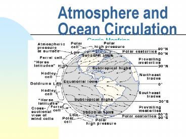
Three major convection cells are present in each
hemisphere.
6-1
Atmospheric Processes
- The Hadley cell extends from the Equator to about
30o latitude. - The Ferrel Cell extends from 30o to about 50o
latitude. - The Polar Cell extends from 90o to about 50o
latitude. - The Coriolis effect causes wind in these cells to
bend to the east or west to form the westerlies,
easterlies, and the trade winds.
9
(No Transcript)
10
Wind-driven currents are produced by the
interaction between the wind and the water.
6-2
Surface Ocean Currents
- As wind moves across the water, collision of air
molecules with water molecules inefficiently
transfers energy from the air to the water. - Water moves at about 3-4 of the wind speed.
- Zonal wind flow is wind moving nearly parallel to
latitude as a result of Coriolis deflection. - Westerly-driven ocean currents in the trade
winds, easterly-driven ocean currents in the
Westerlies and deflection of the ocean currents
by the continents result in a circular current,
called a gyre.
11
Pressure gradients develop in the ocean because
the sea surface is warped into broad mounds and
depressions with a relief of about one meter.
6-2
Surface Ocean Currents
- Mounds on the oceans surface are caused by
converging currents, places where water sinks. - Depressions on the oceans surface are caused by
diverging currents, places from where water
rises. - Water flowing down pressure gradients on the
oceans irregular surface are deflected by the
Coriolis effect. The amount of deflection is a
function of latitude and current speed.
12
With time, wind-driven surface water motion
extends downward into the water column, but speed
decreases and direction changes because of
Coriolis deflection.
6-2
Surface Ocean Currents
- Eckman Spiral is the spiraling pattern described
by changes in water direction and speed with
depth. - Eckman transport is the net transport of water by
wind-induced motion. - Net transport of the water in an Eckman spiral
has a Coriolis deflection of 90o to the direction
of the wind. - Along coastal areas Eckman transport can induce
downwelling or upwelling by driving water towards
or away from the coast, respectively.
13
Eckman Spiral in the Northern Hemisphere
14
6-2
Surface Ocean Currents
- The current flow pattern in gyres is asymmetrical
with narrow, deep and swift currents along the
basins western edge and broad, shallow slower
currents along the basins eastern edge.
Geostrophic Flow Around the North Atlantic Ocean
15
6-2
Surface Ocean Currents
- The geostrophic mound is deflected to the western
part of the ocean basin because of the eastward
rotation of the Earth on its axis. - The Sargasso Sea is a large lens of warm water
encircled by the North Atlantic gyre and
separated from cold waters below and laterally by
a strong thermocline.
16
6-2
Surface Ocean Currents
- Western boundary currents, such as the Gulf
Stream, form a meandering boundary separating
coastal waters from warmer waters in the gyres
center. Meanders can be cut off to form warm-core
and cold-core rings.
17
Formation of Rings
18
Thermohaline circulation is a density driven flow
of water generated by differences in salinity or
temperature.
6-3
Deep-Ocean Circulation
- Water at the surface is exposed to changes in
salinity through evaporation or precipitation and
in temperature through cooling or heating. - Once water sinks and becomes isolated from the
atmosphere, its salinity and temperature are
largely set for an extended period of time. - Based upon depth, surface water masses can be
broadly classified as Central waters (from 0 to 1
km), Intermediate waters (from 1 to 2 km), and
Deep and bottom waters (greater than 2 km).
19
6-3
Deep-Ocean Circulation
- Most deep and bottom water originate at the
surface where cooling and increased salinity
raise their density until they sink. - Ocean basins interconnect and exchange water with
each other and with the surface. Inter-ocean
basin circulation and exchange between surface
and deep water appear largely driven by waters of
the North Atlantic.
20
The major thermohaline currents appear to flow
mainly equatorward, but this is because they
originate in the polar regions and their outward
flow is confined between the continents.
6-3
Deep-Ocean Circulation
- Warmer water (gt10oC) is confined between 45o
north and south latitude. - Poleward of 45o, density of water increases
because of declining temperature and increased
salinity caused by evaporation or ice formation.
21
6-3
Deep-Ocean Circulation
- The water sinks to a density-appropriate level
and then slowly flows equatorward across the
basin. - Deep water gradually mixes with other water
masses and eventually rises to the surface. - The Atlantic Ocean has the most complex ocean
stratification containing the following layers
Antarctic Bottom Water, Antarctic Deep Water,
North Atlantic Deep Water, Arctic Intermediate
Water, and Mediterranean Intermediate Water.
22
6-3
Deep-Ocean Circulation
- The Pacific Ocean has a less complex
stratification, is weakly layered, displays
sluggish circulation and is remarkably uniform
below 2000m. - The Indian Ocean has the simplest stratification
consisting of Common Water, Antarctic
Intermediate Water, and Red Sea Intermediate
Water.
23
Most seas are indentations into continents,
partially isolated from the ocean and strongly
influenced by continental climate and river
drainage.
Water Flow in Semi-enclosed Seaways
6-4
- As Atlantic Ocean water flows through the Straits
of Gibraltar into the Mediterranean Sea at the
surface, warm, highly saline Mediterranean Sea
water flows out through the Straits at the
bottom. - In the Black Sea the surface water is brackish
because of excess precipitation and river inflow.
The bottom water is anoxic.
24
There are two principle ways to measure currents
The Ocean Sciences Current-Measuring Techniques
- Eulerian method employs current meters fixed to
the sea bottom.
Two Impeller Meters
25
The Ocean Sciences Current-Measuring Techniques
- Langrangian method employs drifters, drogues, or
floats that are set loose at the sea surface or
at predetermined depths and tracked acoustically.
The Lagrangian Method
26
The Ocean Sciences Hurricanes and Typhoons
- Hurricanes, which are called typhoons in the
Western Pacific, evolve from tropical cyclones. - In order for hurricanes to form, sea-surface
temperatures down to a water depth of 45m must be
warmer than 27º C and upper-level winds must be
weak. - A cross-sectional view shows that a hurricane
consists of a central eye where winds are light
and skies are clear, surrounded by the eyewall, a
thick band of dense clouds with hurricane-force
winds.
27
Cross-Section of a Hurricane
Recommended
CrystalGraphics Presentations


