
Richard L. Watson, Ph.D., P.G. - PowerPoint PPT Presentation
Title:
Richard L. Watson, Ph.D., P.G.
Description:
Richard L' Watson, Ph'D', P'G' – PowerPoint PPT presentation
Number of Views:33
Avg rating:3.0/5.0
Title: Richard L. Watson, Ph.D., P.G.
1
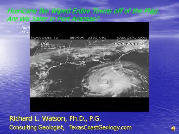
Hurricane Ike Wiped Entire Towns off of the Map.
Are We Safer in Port Aransas?
Hurricane Ike 01-15 September 2008Movie prepared
by Donovan Landreneau, meteorologist, NWS
Richard L. Watson, Ph.D., P.G. Consulting
Geologist, TexasCoastGeology.com
2
Hurricane Ike Landfall Radar Sept 11-15, 2008
TexasCoastGeology.com
3
Ike Tropical Storm force winds 275 miles wide!
Strong Category 2 Wind 110 mph, gusting to 130
mph
4
Ikes diameter was huge!
TexasCoastGeology.com
5
TexasCoastGeology.com
6
TexasCoastGeology.com
7
Rollover Pass, June 16, 2006
TexasCoastGeology.com
8
Rollover Pass, September 15, 2008
Only one house remains!
TexasCoastGeology.com
9
One house left in Gilchrist
TexasCoastGeology.com
10
Last House at Gilchrist, TX
Photo from TGLO
TexasCoastGeology.com
11
You have to be kidding!
TexasCoastGeology.com
12
They are called mobile homes
TexasCoastGeology.com
13
TexasCoastGeology.com
14
The Breakers,1906 Built 1884
TexasCoastGeology.com
15
The Breakers, 1998
TexasCoastGeology.com
16
The Breakers before Ike
Google Earth
After 1998
Before 1998
17
The Breakers after Ike
Gone
Old Foundation
TexasCoastGeology.com
18
Dredging Rates
290,000 cubic yards lost to beaches each year
through Rollover Pass
2.5 million dump trucks so far
From Bales and Holley, 1989
19
The General Land Office is doing a good job
TexasCoastGeology.com
20
Crystal Beach before Ike, Google Earth
21
Crystal Beach after Ike, Oct. 28, 2008
TexasCoastGeology.com
22
This was full of houses
TexasCoastGeology.com
23
Homes were here too!
TexasCoastGeology.com
24
Balinese Club September 15, 2008The seawall did
its job!
TexasCoastGeology.com
25
West Galveston before Ike, Google Earth
TexasCoastGeology.com
26
West Galveston, Sept. 15, 2008
TexasCoastGeology.com
27
This Galveston house used to have a garage!
TexasCoastGeology.com
28
The ramp shows where the dune was before the
storm. New sand has been dumped to replace it.
TexasCoastGeology.com
29
This is real optimism!
TexasCoastGeology.com
30
This was a Galveston street
TexasCoastGeology.com
31
Galveston East Jetty
30 million cubic yards lost to beaches (5 million
dump trucks)
TexasCoastGeology.com
32
Road on Follets Island Sept. 15, 2008
TexasCoastGeology.com
33
Road on Folletts Island
TexasCoastGeology.com
34
Folletts Island homes Sept. 15, 2008
TexasCoastGeology.com
35
Cross bracing is a good idea!
TexasCoastGeology.com
36
Surfside homes on beach Apr. 26, 2007
TexasCoastGeology.com
37
Surfside after Ike Oct. 28, 2008
TexasCoastGeology.com
38
Below the vegetation line, but still have spirit!
TexasCoastGeology.com
39
The Octagon, 1969
From Surfriders website
40
The Octagon, 2000
From Surfriders website
From Surfriders website
41
H. Ike Dune Erosion N. Padre Island
TexasCoastGeology.com
42
Loader Removing Ike Sand Padre Balli Park
TexasCoastGeology.com
43
Sand from Ike dumped at waters edge, Padre Balli
Park
TexasCoastGeology.com
44
Removing Potential Dune Sand
Hurricane Rita Berm
TexasCoastGeology.com
45
Hurricane Rita sandLost to the Natural Dune
Seawall
Thousands of dump trucks!
TexasCoastGeology.com
46
Hurricane Ike berm being removed by City of Port
Aransas
TexasCoastGeology.com
47
Dumping the sand from Ike berm by the water, City
of Port Aransas
TexasCoastGeology.com
48
This widens beach at expense of dunesCity of
Port Aransas
TexasCoastGeology.com
49
Ike sand berm pushed up against dunes, City of
Port Aransas
TexasCoastGeology.com
50
Dumping Between Ridges
TexasCoastGeology.com
51
Stacking Sand behind dune ridges builds the dunes
stronger, 3/6/2009
TexasCoastGeology.com
52
Mid-stacking sand between dune ridges 3/6/2009
TexasCoastGeology.com
53
Disposal behind foredune ridge makes dunes
stronger - April, 2008
Seaweed Sand
TexasCoastGeology.com
54
Narrow beach means little future dune growth
- A wide section of dry beach needed as sand source
for dune growth - We no longer have a wide beach
- The foredunes will no longer grow
- Beach erosion and shoreline retreat now means
loss of the existing foredune ridges - The new 350 ft. setback for Nueces County was
very wise
TexasCoastGeology.com
55
Gulf Shorelines in Texas Are Retreating Because
- Long Jetties permanently trap sand, starving
downdrift beaches and compartmentalizing the
coast. - Reservoirs trap river sand that previously flowed
to the coast. - Reservoirs reduce the maximum flood velocity of
rivers. - Sand is permanently lost through inlets.
TexasCoastGeology.com
56
Gulf Shorelines in Texas Are Retreating Because
- River mouths have been diverted, moving the delta
to a new location. - Rivers have been diverted from the Gulf into the
bays. - The Rio Grande has been turned off.
- Groundwater extraction has caused subsidence.
- Sea level rise moves shorelines landward.
TexasCoastGeology.com
57
Hurricane Carla Wind Field, 1961
Miles O. Hayes, 1967
TexasCoastGeology.com
58
Dune Erosion by Carla, 1961 Dunes eroded back
200 ft on Mustang I.
Miles O. Hayes, 1967
TexasCoastGeology.com
59
Hurricane Carla Inundation, 1961
Carla Surge 8-9 ft. at Port Aransas, dunes not
breached
60
Hurricane Beulah Inundation 1967
Beulah surge about 8 ft., dunes not breached
TexasCoastGeology.com
61
Hurricane Celia Inundation Port Aransas 1970
Celia surge at Port Aransas about 10 ft. Dunes
not breached.
TexasCoastGeology.com
62
All Tropical Storms Since 1851
TexasCoastGeology.com
63
Even Ike cant kill Texas spirit!
Richard L. Watson, Ph.D., P.G. Consulting
Geologist TexasCoastGeology.com (361) 749-4152
Thats All, Folks!
Recommended
CrystalGraphics Presentations


