
SECTION V: FACIES AND STRATIGRAPHY - PowerPoint PPT Presentation
1 / 33
Title: SECTION V: FACIES AND STRATIGRAPHY
1
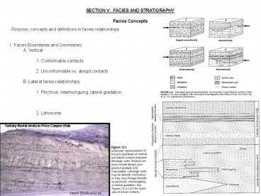
SECTION V FACIES AND STRATIGRAPHY Facies
Concepts
- -Purpose, concepts and definitions in facies
relationships - I. Facies Boundaries and Geometries
- A. Vertical
- 1. Conformable contacts
- 2. Unconformable vs. abrupt contacts
- B. Lateral facies relationships
- 1. Pinchout, intertounguing, lateral gradation
- 2. Lithosome
Tertiary fluvial strata in Price Canyon Utah
Janok Bhattacharya
2
II. Subsidence and Accommodation Space A.
Effects on basin fill volume B. Effects on
basin fill type 1. Flysch vs. Molasse
3
III. Shoreline Shifts and Facies Stacking
Patterns A. Balance between sediment supply and
accommodation B. Facies shifts
seaward, landward, laterally, vertical 1.
Resultant transgression, regression, or vertical
stacking of wedges i. Onlap and offlap and
downlap ii. Aggradation, progradation,
retrogradation
Transgression Vs regression during eustatic rise
(Stanley, 2005)
4
iii. Diachronous beds of transgressive/regressive
deposits IV. Non-migrating environments A.
Aggradation V. Walther's law
5
- VI. Cyclic Sedimentation
- A. Accommodation vs. sediment supply
- 1. Environmental control
- on lithology
6
Stratigraphy -Purpose of stratigraphy -North
American Stratigraphic Code (AAPG, 1983) I.
Formally approved methods of division A.
Material-based divisions 1. By lithology i.
Lithostratigraphy, lithodemic 2. By magnetic
traits i. Magnitostratigraphy 3. By fossil
content i. Biostratigraphy 4. By soil
horizons i. Pedostratigraphy 5. By bounding
surfaces i. Allostratigraphy B. Time- and
rock-based divisions 1. Chronostratigraphy C.
Time-based divisions 1. Geochronologic units D.
Note sequence stratigraphy and seismic
stratigraphy are not listed as formalized, but
are commonly used
7
Lithostratigraphy I. Principles of
Lithostratigraphy A. Lithostratigraphy
concentrates on? B. Lithostratigraphic
units 1. Formation, members, beds, group C.
Lithostratigraphic correlation 1. Physical
tracing 2. Lithologic similarity and
stratigraphic position D. Purposes of
lithostraitgraphy
(Stanley, 2005)
8
Seismic Stratigraphy -Origins I. Mechanics of
seismic reflection A. Collection 1. A vibration
source i. Sources in water are usually air
guns, pingers, etc. ii. Sources on land are
vibrosize, dynamite, etc. 2. Changes in
impedance/velocity translates to reflection 3.
Receivers (geophones) 4. Measuring the travel
time
9
B. Reflectors vs. actual lithologic
boundaries 1. Sources of impedance 2.
Individual bed thickness resolved down to about
1/4 wave length i. In general, resolving beds
as thin as about 1m down to about 75m and
resolving bed only as thin as about 15m thick at
a kilometer or two
10
II. Reflector relationships A. Seismic
facies 1. Parallel and subparallel forms 2.
Divergent 3. Progradational forms i. Parallel
and sigmoid 4. Contorted and chaotic 5.
Reflection free 6. Mounded forms
11
B. Reflector Terminations 1. Onlap 2.
Downlap 3. Toplap 4. Truncation
12
C. An example
13
Sequence Stratigraphy -Sequence Stratigraphy
is? I. Recent History A. Sloss (1963) and
Wheeler B. 1977 and the research group
at Exxon, headed by Peter Vail
Wheelers diagram
Sloss Sequences
(Stanley, 2005)
(AGI Data Sheets, Holbrook in press)
14
II. Surface Relationships (as seen on seismic
lines) A. Underlying unconformity B. Coastal
onlap C. Marine onlap D.
Offlap E. Downlap F. Toplap G.
Internal convergence
Lapping Relationships
15
Parasequences
III. The Parasequence A. 'a relatively
conformable secession of beds or bedsets bound by
marine-flooding surfaces' (Van Wagoner,
1985) 1. A marine flooding surface is sharp
boundary across which an abrupt deepening of
water is recorded by a sudden shift toward more
basinal facies 2. Parasequences and
progradation B. Parasequence sets 1.
Progradational sets 2. Retrogradational
sets 3. Aggradational sets
(Posamentier and Allen, 1999)
Parasequence sets
(Van Wagoner, et al., 1990)
16
IV. Systems Tracts A. 'a linkage of
contemporaneous depositional systems' Van Wagoner
(1985) 1. Defined objectively on the basis of
reflector/surface/parasequence set configuration
and position in a sequence 2. Originally
defined for the continental shelf i.
Shelf-margin assumptions a. Tectonics, basin
physiography, and sediment supply C.
Shelf-margin systems tracts 1. Lowstand 2.
Transgressive 3. Highstand 4. Shelf-margin
wedge i. Type1 vs. Type 2 unconformities
17
Lowstand Systems Tract
Transgressive Systems Tract
(Van Wagoner, et al., 1990)
18
Highstand Systems Tract Lowstand Systems
Tract and Type 1 Unconformity
(Van Wagoner, et al., 1990)
19
Shelf-Margin Systems Tract and Type 2 Unconformity
Missing In Action?
Type 2 Sequence Boundary?
Shelf-Margin Wedge?
(AGI Data Sheets, Holbrook)
20
Ramp-type Basins
D. Ramp-style vs. passive-margin-style 1. Type
1 sequence boundary 2. Type 2 sequence
boundary 3. Transgressive surface of erosion
4. Maximum flooding surface 5. Condensed
section 6. Flooding surfaces
(Van Wagoner, et al., 1990)
21
Sequence Boundaries Across Shelf Deposits
Pennsylvanian, New Mexico
22
Magnetostratigraphy -What is it? I. Principles
A. The Earth's magnetic field 1. Magnetic
poles and lines B. What is remnant
magnetism? 1. Why? 2. When? i. During
suspension and saltation ii. Prior to cooling
in a magma body or lava flow 3. Curie point
usually about 5000C - 6000C 4. Remnant
magnetism and magnetic cleaning
23
II. Magnetic Time Scale A. Normal vs. reversed
polarity magnetic stripes radiometric dating or
fossil zonation 1. Works as far back as
Middle Jurassic B. Divided into Chrons C.
Fundamental magnetopolarity time-rock unit is the
polarity zone
24
III. Magnitostratigraphy Uses A.
Geochronology B. Correlation C.
Paleogeography
Earth Sciences Sector gt Geological Survey of
Canada gt Geomagnetism
25
Biostratigraphy What is biostratigraphy? I.
Fundamentals of Use A. Correlation of
Biozones 1. Fundamental and larger units
26
- B. The Geologic Time Scale
- 1. Law of faunal succession (William Smith)
- 2. The Periods
27
II. Types of Biozones A. Interval zones 1.
Taxon range zone, concurrent range zone, lineage
zone, last-occurrence zone B. Oppel zones
C. Assemblage zones D. Abundance zones
Lineage
Oppel
28
- III. Biozone Durations
- A. Species dependence
- 1. Species variation with time
29
IV. Correlation Problems and Solutions A.
Problems 1. Facies fossil, endemic regions B.
Solutions 1. Index fossils i. Lived for a short
span of time wide-spread not a facies
fossil 2. Stair-stepping zones i. Concept of
the composite assemblage zone 3. Define more
than one biozone for a single interval C.
Assumptions V. Biostratigraphy Purposes 1.
Designation of rock age (about 30
biozones/period) 2. Correlation of rocks
deposited synchronously
30
Chronostratigraphy -What is chronostratigraphy?,
I. Units and Boundaries A. The fundamental
unit is the chronozone B. Establishing
boundaries 1. Numerical dating
31
2. Event Stratigraphy i. Magnetostratigraphic
events ii. Biostratigraphic events iii.
Cycles iv. Singular/random events
32
v. Isotope events
33
C. Chronostratigraphy hierarchy II.
Chronostratigraphy Uses A. Age B. Correlations
Recommended
CrystalGraphics Presentations


