
Gis Data Solution PowerPoint PPT Presentations
All Time
Recommended

GIS: An Integrated Solution Toward Meeting Oceanographic Data Challenges
| PowerPoint PPT presentation | free to download

Apex Advanced Technology (AAT) provides a comprehensive range of geospatial information system (GIS) and engineering data services to the communications, utility, energy, rail, and transit industries. Our in-depth knowledge of geospatial data combined with our around-the-clock, dual-shore service model enables us to deliver high quality results at substantially lower cost, with all project management and technology development conducted by our US-based management team.
| PowerPoint PPT presentation | free to download

Challenges and Solutions for Digital Geospatial Data Preservation Jeff Essic Geospatial Data Service
| PowerPoint PPT presentation | free to download

Title: The Virtual Domain Application Data Center (VDADC): Access to Data in Multiple Formats and Data Visualization Author: HEATHER WEIR Last modified by
| PowerPoint PPT presentation | free to view

Problem with GIS Data Lots of different, related files Results in data that is: Hard to find and share and of questionable quality Need: Containers for datasets:
| PowerPoint PPT presentation | free to view

Siglo Group provides the finest conservation GIS services in Austin. With the effective use of advanced GIS technology, organizations can make resource allocation decisions that are well-informed and, therefore, have positive effects on conservation. Here are some more services: GIS Specialist Austin, Phase i Environmental Site Assessment Austin https://siglogroup.com/what-we-do/conservation-planning/
| PowerPoint PPT presentation | free to download

From the 2-D Map to 1-D Computer Files. 2 * Dr. Stuart Murchison, UTDallas GISC ... 'raster is faster but vector is corrector' Joseph Berry. Raster data model ...
| PowerPoint PPT presentation | free to view

To get the Full insights of GIS Services, Apex Solutions Ltd is the best place to start. This blog has better insights for your business.
| PowerPoint PPT presentation | free to download

case, the zeros in the ocean off of New York and New Jersey. 14. Characteristics of a raster ... 21. Raster Map overlay. SOILS. PARKS. URBAN. SOLUTION. FOREST ...
| PowerPoint PPT presentation | free to view

Marvel Geospatial - a solution for accurate data mapping and management. We at Marvel Geospatial, provide Geospatial Solution with accurate data mapping and management. Our service includes GIS, BIM and LiDAR mounted UAVs. We at Marvel Geospatial, provide you with an ultimate Geospatial Solution with our accurate data mapping and management services. Marvel brings horizontal and vertical integration of Satellite/Aerial Remote Sensing, Positioning Applications, Photogrammetry, GIS Databases and Applications, GIS Web-services and Networking of GIS Databases.Marvel offers expert advice and reliable data for all geospatial needs. Discover what’s possible with Marvel. Give us a call today for a free consultation!
| PowerPoint PPT presentation | free to download

GIS and Spatial Data Management Explained Corey Tucker Tamarack Geographic Technologies Data Standards Is everyone working together? Who ultimately decides what ...
| PowerPoint PPT presentation | free to view

Start your GIS analysis by figuring out what information you need. ... on a map is kept very clean, very simple, and uncluttered with graphic symbology ...
| PowerPoint PPT presentation | free to view

PT FREEPORT INDONESIA WEB GIS AND DATA INTEGRATION SYSTEM IMPLEMENTATION Harman Setyadi Mine Engineering Dept, Bandung Institute of Technology ASIA GEOSPATIAL FORUM ...
| PowerPoint PPT presentation | free to view

GIS TECHNOLOGY SDI THE INTELLIGENT GEOSPATIAL DATA MANAGEMENT
| PowerPoint PPT presentation | free to view

... GIS data collection and update,' Photogrammetric Week '99. Fritsch and R. ... from scanned thematic maps ,' Photogrammetric Engineering and Remote Sensing. ...
| PowerPoint PPT presentation | free to view

Ferris State University GIS project: integration of spatial data technologies
| PowerPoint PPT presentation | free to view

Web-based and Mobile GIS for High School GIS Career Awareness. by Dr. Ming-Hsiang (Ming) Tsou ... Barnacle (Boat Channel Study: HTH Biotech Website) Flatworm ...
| PowerPoint PPT presentation | free to download

Integrating GIS and Community Mapping into Secondary Science Education: A Web GIS Approach Liz O Dea Department of Geosciences Introduction GIS: program combining ...
| PowerPoint PPT presentation | free to download

What are the most important problem hindering wide use of GIS today? ... A rational man (a.k.a. homo economicus) decides between action ...
| PowerPoint PPT presentation | free to view

GIS Modeling Week 2 Maps as Data GEOG 3110 University of Denver Presented by Joseph K. Berry W. M. Keck Scholar, Department of Geography, University of Denver
| PowerPoint PPT presentation | free to download

The Integration of Model Results and GIS via the Marine Data Model ... 1. Hydrography. 2. Hydrology. 3. Time Series. Marine model. 1. Deep Sea. 2. Near Shore ...
| PowerPoint PPT presentation | free to view

... communication among designers, developers, and users ... in a completely rigorous and unambiguous fashion on which both user and GIS analyst agree ...
| PowerPoint PPT presentation | free to download

Academia de Studii Economice din Bucuresti Facultatea de Relatii Economice Internationale GIS solutions in real estate and economics fields-Bucharest and ASE Study cases-
| PowerPoint PPT presentation | free to view

Modeling of Urban Sprawl Hazard in AL-Qalubia Governorate, Egypt Using Remotely Sensed Data and GIS Dr. Islam Abou El-Magd NARSS Overview Introduction Objective ...
| PowerPoint PPT presentation | free to view

1. Mapping the Fear of Crime, a Web Based GIS Solution to ... Conservative Advert 'This misleading advert quite improperly seeks to stir up fear of rising crime ...
| PowerPoint PPT presentation | free to download

Iowa Environmental Mesonet: Using Open Source GIS Tools and Web Services to Disseminate Environmental Data Daryl Herzmann Iowa State University Data, data, everywhere ...
| PowerPoint PPT presentation | free to download

2006 State of the State in GIS A New York State GIS Showcase
| PowerPoint PPT presentation | free to view

Determining Flow Systems Using Chemical Data and GIS in Cuatro Cienegas, ... 2001, Hydrologic Synopsis en the Hundido, Cuatrocienegas, and Ocampo Valleys, ...
| PowerPoint PPT presentation | free to download

Note: Percentages based on the actual number of respondents to ... Also, archiving data does not guarantee ' ... to PREMIS, MODS? Metadata wrapper ...
| PowerPoint PPT presentation | free to download

CDs, local machine, or network access. Numeric Data access issues ... 'Learned where to obtain information online that can be useful in other classes. ...
| PowerPoint PPT presentation | free to view

Introduction to GIS Modeling Week 7 GIS Modeling Examples GEOG 3110 University of Denver Winter, 200
| PowerPoint PPT presentation | free to view

Decision-making Process: GIS-based System for Winthrop's First Responders and Decision Makers During a Flood Evacuation Test Case: Evacuating Winthrop ...
| PowerPoint PPT presentation | free to download

Unidata and NCAR activities to integrate scientific data systems and tools with GIS databases and se
| PowerPoint PPT presentation | free to view

... PMS Use the LRS to Integrate data from other systems CMMS (streets, signs, sidewalks), ADT, speed limits, bike routes, accidents, ...
| PowerPoint PPT presentation | free to view

Non-GIS: Infrastructure (buildings, plant operations. One call ... Annexation. Service delivery changes. Shared use facilities. Spatial analysis of work orders ...
| PowerPoint PPT presentation | free to download

North Carolina Geospatial Data Archiving Project/NDIIPP: Collection and preservation of at-risk digital geospatial data Partners: NCSU Libraries
| PowerPoint PPT presentation | free to download

Next Generation Archives: The NC Geospatial Data Archiving Project Jeff Essic Geospatial Data Servic
| PowerPoint PPT presentation | free to download

Preserving State and Local Agency Digital Geospatial Data NC Geospatial Data Archiving Project NCGDA
| PowerPoint PPT presentation | free to download

Sharing Spatially-Organized Urban Data ... Sharing GIS data is inefficient. Traditional Solutions: --Contact colleague or government agency ...
| PowerPoint PPT presentation | free to view

Geospatial solutions collect, manage, organize, and store data pertaining to geographic information such as zip codes, addresses, or latitudinal and longitudinal coordinates to a location. This includes data accumulated by satellites, digital and analog maps, and street and aerial imagery. Some instances of geospatial solution technologies include Global Positioning Systems (GPS), Geographic Information Systems (GIS), imagery analysis, and remote sensing.
| PowerPoint PPT presentation | free to download

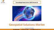
The global market for geospatial solutions is projected to grow at a compound annual growth rate (CAGR) of 13.8%, reaching a value of US$1,691.4 billion by the end of 2030, up from US$684.3 billion in 2023. The geospatial solution market, a dynamic sector in the technology industry, utilizes spatial data to provide valuable insights into location intelligence. Geospatial solutions leverage various technologies, including geographic information systems (GIS), global positioning systems (GPS), and remote sensing, to analyze and interpret spatial information. These solutions play a crucial role in different sectors by facilitating informed decision-making through the mapping and visualization of geographical data.
| PowerPoint PPT presentation | free to download
Outline. GIS overview. GIS data and layers. GIS applications and examples. Software overview. GIS tutorial 1 overview. GIS TUTORIAL 1 - Basic Workbook
| PowerPoint PPT presentation | free to download

... from GIS to HEC-RAS. Model building ... HEC-RAS. robust numerical solutions for ... HEC-RAS 3.11. AutoCAD 2005. perform trials in using output data to ...
| PowerPoint PPT presentation | free to view

What is GIS? Geographic Information Systems (GIS) are computerized systems designed for the storage, retrieval and analysis of geographically referenced data
| PowerPoint PPT presentation | free to view

Exploring Solution Options URNM and the GIS Strategy
| PowerPoint PPT presentation | free to view

Introduction to GIS Basic overview: What is GIS, what types of data, what applications? Topics GIS part of course Basic knowledge geography, cartography GIS data and ...
| PowerPoint PPT presentation | free to view

Digital imaging, GIS, GUI, tables, multi-dimensions, graphs, VR, 3D, animation ... Data input from maps, aerial photos, etc. Data storage, retrieval and query ...
| PowerPoint PPT presentation | free to view

Example GIS: Potential machinist application within the city Pittsburgh. ... Pittsburgh Post Gazette. Todd Fichera-IAMAW. Megan Grabski-New Century Careers. ESPN.com ...
| PowerPoint PPT presentation | free to view

GIS in Water Resources Review for Midterm Exam Data Models A geographic data model is a structure for organizing geospatial data so that it can be easily stored and ...
| PowerPoint PPT presentation | free to view

Data Warehousing University of California, Berkeley School of Information Management and Systems SIMS 257: Database Management Lecture Outline Lecture Outline A ...
| PowerPoint PPT presentation | free to download
The Global Geospatial Solutions Market size is expected to reach $549.1 billion by 2025, rising at a market growth of 15.6% CAGR during the forecast period. A broad variety of factors drive the geospatial solutions industry, including advances in geospatial technologies with the advent of artificial intelligence and big data analytics. The inclusion of geospatial systems with conventional processes is another consideration that speeds up market growth. On the contrary, regulations and legal problems were discovered to impede the development pace of the industry. Full Report: https://www.kbvresearch.com/geospatial-solutions-market/
| PowerPoint PPT presentation | free to download

GIS Portal Toolkit 9.3. Marten Hogeweg. Evolving Spatial Data Infrastructures ... INSPIRE, North American Profile, ANZLIC, Earth Observation Profile, NATO ...
| PowerPoint PPT presentation | free to view

You have tracts for state but want one county only. GIS 5 ... Clean 'cut' Select by Location: Dangle edges. GIS 27. Dissolving Features. GIS 28. Dissolve ...
| PowerPoint PPT presentation | free to download

AN INTRODUCTION TO GIS SYSTEMS TAKEN AND MODIFIED FROM TEXT BY David J. Buckley Corporate GIS Solutions Manager Pacific Meridian Resources, Inc. WHAT IS A GIS ?
| PowerPoint PPT presentation | free to view
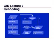
Street Map. Polygon Address Matching. Improving the Process. Geomasking. WEB Sites. GIS 3 ... GIS 13. Linear Address Matching (Streets) Urban street maps ...
| PowerPoint PPT presentation | free to download

Maps. Remotely-sensed Images. Spatially-referenced Data. NSDI. Data ... Australia. NSDI. Types of GIS Standards. Data Classification. Data Content ...
| PowerPoint PPT presentation | free to download