Archiving of Historic Environmental Sensitivity Index Maps - PowerPoint PPT Presentation
1 / 15
Title:
Archiving of Historic Environmental Sensitivity Index Maps
Description:
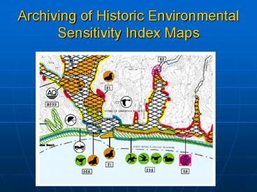
Example of the (26) 24x24 in. sheets from the South FL #2 atlas ... 300 dpi 11'x17' color print of each map. TIFF and PDF of each page ... – PowerPoint PPT presentation
Number of Views:81
Avg rating:3.0/5.0
Title: Archiving of Historic Environmental Sensitivity Index Maps
1
Archiving of Historic Environmental Sensitivity
Index Maps
2
ESIs Provide
- Information on Coastal Resources
- Record of Shoreline Goemorphology
- Shoreline position
- Biological Communities
- in intertidal and nearshore areas
3
Task
- 1,970 map sheets from 45 atlases (Pre-electronic,
1978s and 1980s) - For 1,667, 4x 5 negatives are available (scan
at 1000 dpi for a final product of 11 x 17 300
dpi) - For remainder, will need to be scanned from
original sheets (both color and BW) (sizes 8.5
x 11 to 24 x 29) - Supporting documentation for atlases (221 pages)
- 4 x 5 negatives or paper up to 14 x 17
4
Example of the (1762) 4x5 in. negatives
5
Example of the (108) 8.5x11 in. sheets from the
Bristol Bay, Alaska atlas
6
Example of the (43) 22x29 in. sheets from the
Prince William Sound Norton Sound, Alaska
Atlases
7
Example of the (26) 24x24 in. sheets from the
South FL 2 atlas
8
Another example of the (26) 24x24 in. sheets from
the South FL 2 atlas
9
Example of the (151) 11x17 in. sheets from the
Guam, Louisiana, and OR/WA- Columbia River atlases
10
Another example of the (151) 11x17 in. sheets
from the Guam, Louisiana, and OR/WA- Columbia
River atlases
11
Another example of the (151) 11x17 in. sheets
from the Guam, Louisiana, and OR/WA- Columbia
River atlases
12
Example of the (118) 14x17 in. intro pages
13
Another example of the (118) 14x17 in. intro
sheets
14
Example of the (8) 11x14 in. sheets from MD atlas
15
Deliverables
- 300 dpi 11x17 color print of each map
- TIFF and PDF of each page
- PDF project for each atlas (atlas directory)
Will be made available to public via Web site


