Analyses - PowerPoint PPT Presentation
1 / 1
Title:
Analyses
Description:
... were stratified according to the bedrock lithology in the park (see map at left) ... cation patterns relative to bedrock lithology are similar for surface waters, ... – PowerPoint PPT presentation
Number of Views:21
Avg rating:3.0/5.0
Title: Analyses
1
Base Cations In Northern Red Oak Trees, Soils,
and Surface Waters of Shenandoah National Park,
VA J.R. Webb, B.J. Cosby, J.C. Blankinship, D.L.
Welsch and F.A. Deviney, Jr. Department of
Environmental Sciences, University of Virginia,
Charlottesville, Virginia
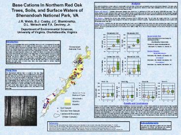
Analyses The current distributions of base
cations in streamwater, soils and trees of SNP
was summarized using box and whisker diagrams.
The base cation data were stratified according to
the bedrock lithology in the park (see map at
left). Patterns in base cation availability
across the landscape can be examined by comparing
the distributions within each bedrock class.
Streamwater Samples - Quarterly streamwater
samples were taken from 14 catchments in SNP over
the period 1988-1999 (see map). The 12 spring
samples for each catchment were used in this
analysis (spring concentrations are the nearest
to volume weighted annual average in gauged
catchments with weekly sampling in the park). The
bedrock type with greatest areal extent in each
catchment determined the bedrock classification
for the catchment (most catchments were gt 90 of
a single bedrock type). Soil Samples -
Seventy-nine soil pits were sampled throughout
SNP in 2000 (see map). The pits were all located
within the 14 monitored catchments in the park.
Each pit was assigned to the bedrock class based
on which it occurred. Duplicate pits were
sampled at some locations and the average values
used here. Wood Samples Northern red oak trees
were sampled with a tree corer in 2000 at 28
sites where soils were sampled (see map). Cores
were obtained from the bole wood of three trees
at each site. The cores were subdivided into
ten-year increments and each increment analyzed
for base cations. The results presented here are
for the increment from 1980 to 1990. This is the
most recent sample of wood tissue that does not
contain active sapwood.
Results and Conclusions There is a clear
pattern of decreasing base cation availability in
the forest ecosystems of SNP. Areas underlain by
basaltic bedrock have a greater capacity for
export of base cations in streamwater, have
higher soils base saturations, and have higher
bole wood content of the important nutrient
cations Ca and Mg. Granitic areas are
intermediate, and siliciclastic areas have the
lowest base cation availability. The base cation
patterns relative to bedrock lithology are
similar for surface waters, soils, and bole wood
of red oak trees. In particular, patterns of Ca
and Mg in bole wood correspond with base cation
availability in soils and base cation export in
streams. This has not been demonstrated
previously for southeastern forests. The
siliciclastic landscape units have significantly
lower availability of base cations in all
components of the ecosystem. Because the
reservoir of base cations are relatively low,
this landscape unit is especially sensitive to
loss of base cations. The implications of base
cation loss for forest health and suitability of
aquatic habitat are of particular concern for
these areas.
Box and Whisker Plots The box and whisker plots
here display the following percentiles 5, 25
50, 75 and 95. The bedrock classes are
abbreviated as Siliciclastic - S, Granitic - G,
Basaltic - B. Number of Samples Streamwater
analyses Siliciclastic - 60, Granitic - 48,
Basaltic - 60. Soil analyses Siliciclastic -
28, Granitic - 26, Basaltic - 25. Wood
analyses Siliciclastic - 23, Granitic - 30,
Basaltic - 27.
Introduction Depletion of exchangeable base
cations (especially calcium) in soils is
recognized as a problem with significant
implications for the health of forest ecosystems.
Forest soils are the principal source of base
cations that serve as essential nutrients for
forest vegetation and serve to buffer the effects
of acidic deposition in surface water. Factors
that may reduce base-cation supplies in forest
soils include uptake associated with forest
regeneration (Hornbeck, 1992) and leaching
associated with acidic deposition (Likens et al.,
1996). The effects of low base-cation
availability have been well quantified with
respect to the acidification of streams draining
forested mountain watersheds in western Virginia
(Webb et al., 1989). Although Lawrence and
Huntington (1999) estimate that calcium supplies
in forest soils in many areas of the southeastern
U.S. are presently insufficient to support forest
regeneration, quantitative studies of the
base-cation status in forests of western Virginia
are limited. Here we describe initial efforts to
examine linkages between the base status of
forest soils, trees, and stream waters in western
Virginias Shenandoah National Park.
Study Sites The Shenandoah National Park is
located in the Blue Ridge Mountains in western
Virginia. Prior to establishment of the park in
the late 1920s, the forest in the park area was
intensively harvested and much of the land was
cleared for agriculture. At present, most of the
park is protected from direct human disturbance
and occupied by a regenerating mixed hardwood
forest of about 70-years age. Ecosytem
variability in the park, including forest-cover
type and fish species distributions, is closely
associated with the distribution of the parks
three major bedrock types. These include
siliciclastic rocks (sandstones and shales),
granitic rocks, and basaltic rocks (see map).
References Hornbeck, J.W. 1992. Comparative
impacts of forest harvest and acid precipitation
on soil and stream water acidity. Environmental
Pollution, 77 151-155. Lawrence, G.B., and T.G.
Huntington. 1999. Soil-Calcium Depletion Linked
to Acid Rain and Forest Growth in the Eastern
United States. USGS, WRIR 98-4267. Likens, G.E.,
C.T. Driscoll, and D.C. Buso. 1996. Long-term
effects of acid rain response and recovery of a
forest ecosystem. Science, 274 244-246. Webb,
J.R., B.J. Cosby, J.N. Galloway, and G.M.
Hornberger. 1989. Acidification of native brook
trout streams in Virginia. Water Resources
Research, 251367-1377.
Acknowledgments This work was supported by grants
from the Virginia Department of Forestry, the
National Park Service, and the U.S. Environmental
Protection Agency.


