The Pacific Ocean - PowerPoint PPT Presentation
1 / 13
Title:
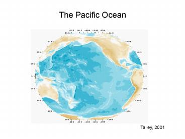
The Pacific Ocean
Description:
They are basically associated with the ITCZ. The position of the continents shifts the ... Pacific salinity section with inset map showing 150w. 32 S. 24 N ... – PowerPoint PPT presentation
Number of Views:866
Avg rating:3.0/5.0
Title: The Pacific Ocean
1
The Pacific Ocean
Talley, 2001
2
Major Pacific Current Systems
3
Equatorial Surface Currents
- Trade winds in both northern and southern
hemispheres separated by a region of light winds,
the Doldrums - They are basically associated with the ITCZ
- The position of the continents shifts the
doldrums into the northern hemisphere (instead of
directly on the Equator)
Segar, 2007
4
Sea level pressure and surface wind
5
Equatorial Surface Currents
- The observed wind pattern sets up the Ekman
transports in the Equatorial region - Note the change in Ekman transport at the Equator
- This sets up patterns of raised and lowered sea
surface height
Segar, 2007
6
Equatorial Surface Currents
- The normal sea surface slope up into the
sub-tropical regions is present - Additionally, there is a region of high sea
surface near the the doldrums, produced by the
northward Ekman transport in the region just
north of the Equator - These slopes set up the Equatorial current system
Segar, 2007
7
Equatorial Surface Currents
- Flow from 5N is directed south by the pressure
gradient and then turned to the right by the
Coriolis Effect, producing the westward South
Equatorial Current (SEC) - Similar process south of the Equator (with a
deflection to the left) also help strengthen the
SEC - Farther north, the North Equatorial Current (NEC)
and the Equatorial Counter Current (ECC) are
generated
Segar, 2007
8
Equatorial Surface Currents
- The strong currents to the west lead to water
piling up along the western boundary - To balance this, the Equatorial Undercurrent
(EUC) is generated - This is a strong and fast current that flows
directly along the Equator
Segar, 2007
9
Equatorial Surface Currents
- EUC found at 50-300 m depth
- Flows purely east-west as no Coriolis deflection
at the Equator - Additionally, if it moves north or south of the
Equator, the Coriolis deflections help direct it
back to the Equator - Flows thousands of kms from west-to-east across
the tropical Pacific - Note Similar behavior (somewhat) in other basins
Segar, 2007
10
Pacific layering salinity
Pacific salinity section with inset map showing
150w
Lower salinity - Antarctic and N. Pacific
intermediate waters
Higher salinity - Atlantic/Ant- arctic waters
32S
24N
Talley, 2001
11
Oxygen at 1000 meters
Yellow low oxygen concentration
High oxygen sources are in the Okhotsk Sea and in
the southeast Pacific (sources of North Pacific
and Antarctic Intermediate Waters)
Blue high oxygen concentration
Talley, 2001
12
Abyssal circulation (4000 dbar)
Two anticyclonic gyres
Samoan Passage constriction of deep northward flow
Deep western boundary current
Talley, 2001
13
Abyssal radiocarbon
Penetration of higher values in the west, lowest
values in the northeast


