
Agassiz Glacie - PowerPoint PPT Presentation
1 / 44
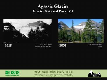
Title: Agassiz Glacie
1
Agassiz Glacier Glacier National Park, MT
Greg Pederson photo USGS
2005
W. C. Alden photo courtesy of GNP archives
1913
USGS Repeat Photography Project http//nrmsc.usg
s.gov/repeatphoto/
2
Agassiz Glacier Glacier National Park, MT
Greg Pederson photo USGS
2005
M. V. Walker photo courtesy of GNP archives
1943
USGS Repeat Photography Project http//nrmsc.usg
s.gov/repeatphoto/
3
Blackfoot Jackson Glacier Glacier National
Park, MT
E. C. Stebinger photo courtesy of GNP archives
1914
2009
Lisa McKeon photo USGS
USGS Repeat Photography Project http//nrmsc.usg
s.gov/repeatphoto/
4
Blackfoot and Jackson Glaciers Glacier National
Park, MT
1911
EC Stebinger photo GNP Archives
2009
Lisa McKeon photo USGS
USGS Repeat Photography Project http//nrmsc.usg
s.gov/repeatphoto/
5
Boulder Glacier Glacier National Park, MT
1932
Jerry DeSanto photo K. Ross Toole
Archives Mansfield Library, UM
1988
T. J. Hileman photo courtesy of GNP archives
USGS Repeat Photography Project http//nrmsc.usg
s.gov/repeatphoto/
6
Boulder Glacier Glacier National Park, MT
Greg Pederson photo USGS
2005
T. J. Hileman photo courtesy of GNP archives
1932
USGS Repeat Photography Project http//nrmsc.usg
s.gov/repeatphoto/
7
Boulder Glacier Glacier National Park, MT
circa 1910
Morton Elrod photo courtesy of GNP archives
2007
Fagre / Pederson photo USGS
USGS Repeat Photography Project http//nrmsc.usg
s.gov/repeatphoto/
8
Chaney Glacier Glacier National Park, MT
Blase Reardon photo USGS
2005
M.R. Campbell photo USGS Photographic Library
1911
USGS Repeat Photography Project http//nrmsc.usg
s.gov/repeatphoto/
9
Chaney Glacier Glacier National Park, MT
Blase Reardon photo USGS
2005
M.R. Campbell photo USGS Photographic Library
1911
USGS Repeat Photography Project http//nrmsc.usg
s.gov/repeatphoto/
10
(No Transcript)
11
Grant Glacier Glacier National Park, MT
Karen Holzer photo USGS
1998
Morton Elrod photo courtesy of GNP Archives
1902
USGS Repeat Photography Project http//nrmsc.usg
s.gov/repeatphoto/
12
Grinnell Glacier Glacier National Park, MT
Lisa McKeon photo, USGS
2008
F. E. Matthes photo courtesy of GNP Archives
1900
In 1900 Grinnell Glaciers mass filled the cirque
basin. This early photo shows the glaciers
height along the headwall and how it was once
joined the upper ice portion, now called The
Salamander.
USGS Repeat Photography Project http//nrmsc.usg
s.gov/repeatphoto/
13
Grinnell Glacier Glacier National Park, MT
Lisa McKeon photo, USGS
2008
Fred Kiser photo courtesy of GNP Archives
1910
USGS Repeat Photography Project http//nrmsc.usg
s.gov/repeatphoto/
14
Grinnell Glacier Glacier National Park, MT
Lisa McKeon photo, USGS
2008
Stanton photo courtesy of GNP Archives
1911
Nearly a century after Stantons photograph was
taken, Grinnell Glacier has receded Into its
cirque basin and is no longer visible from the
trail above Grinnell Lake.
USGS Repeat Photography Project http//nrmsc.usg
s.gov/repeatphoto/
15
Grinnell Glacier Glacier National Park, MT
Lisa McKeon photo, USGS
2008
Lieutenant Beacon courtesy of GNP Archives
1887
Among the earliest photos of Grinnell Glacier,
this 1887 image shows the Immense extent and
depth of the glacier at the turn of the 2oth
century. The glacier has responded to
temperature and precipitation in the past 100
years, resulting in its obvious reduction in
size.
USGS Repeat Photography Project http//nrmsc.usg
s.gov/repeatphoto/
16
Grinnell Glacier Glacier National Park, MT
2008
circa 1920
Lisa McKeon photo, USGS
T. J. Hileman photo courtesy of GNP Archives
In addition to the change in the size of Grinnell
Glacier, there is obvious change in the
foreground streamside vegetation between these
two images.
USGS Repeat Photography Project http//nrmsc.usg
s.gov/repeatphoto/
17
Grinnell Glacier Glacier National Park, MT
1914
Marble photo courtesy GNP Archives
1938
T. J. Hileman photo courtesy GNP Archives
2008
Lisa McKeon photo USGS
Grinnell Glacier from the shore of Lake Josephine
USGS Repeat Photography Project http//nrmsc.usg
s.gov/repeatphoto/
18
Grinnell Glacier Glacier National Park, MT
1938
2009
T. J. Hileman photo Courtesy of GNP Archives
Lindsey Bengtson photo USGS
Oblique view of Grinnell Glacier taken from the
summit of Mount Gould, Glacier National Park.
The relative sensitivity of glaciers to climate
change is illustrated by the dramatic recession
of Grinnell Glacier while surrounding vegetation
patterns remain stable.
USGS Repeat Photography Project http//nrmsc.usg
s.gov/repeatphoto/
19
Grinnell Glacier Glacier National Park, MT
T. J. Hileman photo Courtesy of GNP Archives
1938
2009
1981
1998
Carl Key photo USGS
D. Fagre photo USGS
Lindsey Bengtson photo USGS
Oblique view of Grinnell Glacier taken from the
summit of Mount Gould, Glacier National Park.
The relative sensitivity of glaciers to climate
change is illustrated by the dramatic recession
of Grinnell Glacier while surrounding vegetation
patterns remain stable.
USGS Repeat Photography Project http//nrmsc.usg
s.gov/repeatphoto/
20
Grinnell Glacier Glacier National Park, MT
Karen Holzer photo USGS
2006
Unknown photographer Courtesy of GNP Archives
circa 1940
Grinnell Glacier taken from the Grinnell Glacier
Overlook off the Highline Trail, Glacier National
Park. The view of Grinnell Glacier taken circa
1940 shows the early formation of Upper Grinnell
Lake, a proglacial lake visible at the terminus
of the glacier. The 2006 photo shows a dramatic
increase in the size of the lake as a result of
melting ice..
USGS Repeat Photography Project http//nrmsc.usg
s.gov/repeatphoto/
21
Grinnell Glacier Glacier National Park, MT
2008
1920
Chris Miller photo USGS
Unknown photographer Courtesy of NPS Historic
Photograph Collection Harpers Ferry Center
The 1920 photo shows National Park Service
Director, Steven Mather, on Piatt Path near
present day Grinnell Glacier Overlook. Darren
Pfeifle strikes a similar pose in the 2008 repeat
photograph.
USGS Repeat Photography Project http//nrmsc.usg
s.gov/repeatphoto/
22
Grinnell Glacier Glacier National Park, MT
2008
1922
Lisa McKeon photo USGS
Morton Elrod photo K. Ross Toole
Archives Mansfield Library, UM
View from north moraine of Grinnell Glacier
USGS Repeat Photography Project http//nrmsc.usg
s.gov/repeatphoto/
23
Grinnell Glacier Glacier National Park, MT
Lisa McKeon photo USGS
2008
Morton Elrod photo K. Ross Toole
Archives Mansfield Library, UM
1924
North moraine of Grinnell Glacier In 1924 the
glaciers ice margin was still in proximity to
its lateral moraine
USGS Repeat Photography Project http//nrmsc.usg
s.gov/repeatphoto/
24
Grinnell Glacier Glacier National Park, MT
Chris Miller photo, USGS
2008
W. C. Alden photo USGS Photographic Library
1920
This pair of photographs from Grinnell Glaciers
southeast edge shows the dramatic change in the
glaciers volume and area. Note the glaciers
depth along the headwall and its extent at the
terminal moraine in the historic photograph.
USGS Repeat Photography Project http//nrmsc.usg
s.gov/repeatphoto/
25
Grinnell Glacier Glacier National Park, MT
2008
1924
Morton Elrod photo K. Ross Toole Archives
Mansfield Library, UM
Lisa McKeon photo USGS
This large boulder was used by Morton Elrod and
other scientists as a baseline to measure the
retreat of Grinnell Glaciers terminus. It is
now referred to as Elrods Rock, and the
glaciers terminus is no longer visible from
this point.
USGS Repeat Photography Project http//nrmsc.usg
s.gov/repeatphoto/
26
Grinnell Glacier Glacier National Park, MT
Lisa McKeon photo USGS
2008
Morton Elrod photo K. Ross Toole Archives
Mansfield Library, UM
1926
This large boulder was used by Morton Elrod and
other scientists as a baseline to measure the
retreat of Grinnell Glaciers terminus. It is
now referred to as Elrods Rock, and the
glaciers terminus is no longer visible from
this point.
USGS Repeat Photography Project http//nrmsc.usg
s.gov/repeatphoto/
27
Grinnell Glacier Glacier National Park, MT
Dan Fagre photo, USGS
8-26-2010
W. C. Alden photo USGS Photographic Library
7-16-1936
USGS Repeat Photography Project http//nrmsc.usg
s.gov/repeatphoto/
28
Harrison Glacier Glacier National Park, MT
2009
1913
Ralph Thornton, USGS photo
W. C. Alden photo, USGS
While difficult to quantify, this photo pair of
Harrison Glacier exemplifies the loss of glacier
volume. Comparison of the ice profile in the
foreground of the photos shows a marked thinning
of the glacier over the years,. Colorful layers
of sedimentary bedrock are being exposed as the
glacier recedes from the cliff bands.
USGS Repeat Photography Project http//nrmsc.usg
s.gov/repeatphoto/
29
Hidden Lake Glacier National Park, MT
Lisa McKeon photo USGS
2009
TJ Hileman photo GNP Archives
circa 1930
Alpine regions along the shores of Hidden Lake
(1943 m) show tremendous expansion of vegetation
in these photos, especially at the base of
Bearhat Mountain (left).
USGS Repeat Photography Project http//nrmsc.usg
s.gov/repeatphoto/
30
Hidden Lake Glacier National Park, MT
Lindsey Bengtson photo USGS
2009
TJ Hileman photo GNP Archives
circa 1930
Vegetation in-growth on the peninsula and
surrounding lakeshore are evident in this pair of
photos.
USGS Repeat Photography Project http//nrmsc.usg
s.gov/repeatphoto/
31
Jackson Glacier Glacier National Park, MT
Lisa McKeon photo, USGS
2009
M. Elrod photo K. Ross Toole Archives Mansfield
Library, UM
1911
USGS Repeat Photography Project http//nrmsc.usg
s.gov/repeatphoto/
32
Piegan Glacier Glacier National Park, MT
Lisa McKeon photo USGS
1998
George Ruhle photo courtesy of GNP Archives
circa 1930
Piegan Glacier appears visibly unchanged in this
pair, but the meadow in foreground has undergone
significant vegetation change.
USGS Repeat Photography Project http//nrmsc.usg
s.gov/repeatphoto/
33
Piegan Glacier Glacier National Park, MT
Lisa McKeon photo USGS
1998
T. J. Hileman photo courtesy of GNP Archives
1938
View from Mount Siyeh Piegan Glacier is one of
the few glaciers in Glacier National Park that
has not significantly changed since photographed
in the 1930s.
USGS Repeat Photography Project http//nrmsc.usg
s.gov/repeatphoto/
34
Red Eagle and Logan Glaciers Glacier National
Park, MT
2009
1914
Lisa McKeon photo USGS
EC Stebinger photo GNP Archives
Although the 2009 photo location does not exactly
match the historic photo station, a comparison of
relative glacial coverage can still be made.
Logan Glacier is in the foreground, while Red
Eagle Glacier sits beneath the pyramidal peak
that bears the same name.
USGS Repeat Photography Project http//nrmsc.usg
s.gov/repeatphoto/
35
Sexton Glacier Glacier National Park, MT
Lisa McKeon photo USGS
1998
Matthes photo courtesy of GNP Archives
1901
USGS Repeat Photography Project http//nrmsc.usg
s.gov/repeatphoto/
36
Shepard Glacier Glacier National Park, MT
Blase Reardon photo USGS
2005
W. C. Alden photo USGS Photographic Library
1913
USGS Repeat Photography Project http//nrmsc.usg
s.gov/repeatphoto/
37
Sperry Glacier Glacier National Park, MT
1913
W. C. Alden photo, courtesy GNP Archives
2008
Lisa McKeon photo, USGS
In 1913, Sperry Glaciers mass spanned across the
entire basin and the glaciers terminus was
recorded at over 150 ft. tall. Contemporary
images show how the glacier has receded and
separated into fragments.
USGS Repeat Photography Project http//nrmsc.usg
s.gov/repeatphoto/
38
Sperry Glacier Glacier National Park, MT
Chris Miller photo, USGS
2009
Marble photo K. Ross Toole Archives University of
Montana
Circa 1930s
The expanse of Sperry Glacier that once greeted
hikers facing NE on Comeau Pass is in stark
contrast to the bedrock and vegetation that has
since emerged as the ice retreated. The Marble
image, most likely taken in the 1920s or early
1930s, was featured on a postcard with this
caption " Sperry Glacier from the river."
USGS Repeat Photography Project http//nrmsc.usg
s.gov/repeatphoto/
39
Sperry Glacier Glacier National Park, MT
Lisa McKeon photo, USGS
2008
Morton Elrod photo K. Ross Toole
Archives Mansfield Library, UM
circa1930
Repeating Elrods photograph from the same photo
point was impossible since he shot from the
elevated perspective of the glaciers surface.
The terminus of the glacier has retreated
beyond the field of view, but these images give a
sense of the glaciers extent and mass early in
the 20th century.
USGS Repeat Photography Project http//nrmsc.usg
s.gov/repeatphoto/
40
Sperry Glacier Glacier National Park, MT
2001
1907
Lisa McKeon photo USGS
Morton Elrod photo courtesy of GNP Archives
The northwest portion of Sperry Glacier once
spanned Comeau Pass to the base of Edwards
Mountain.
USGS Repeat Photography Project http//nrmsc.usg
s.gov/repeatphoto/
41
Sperry Glacier northeast view Glacier National
Park, MT
Lisa McKeon photo, USGS Sept. 15, 2007
2007
Alden photo, courtesy of GNP Archives Aug. 13,
1913
1913
This view of the northeast portion of Sperry
Glacier shows evidence of the glacier's recession
as well as the advancement of conifer species and
other vegetation on the glacial moraines..
USGS Repeat Photography Project http//nrmsc.usg
s.gov/repeatphoto/
42
Swiftcurrent Glacier Glacier National Park, MT
Karen Holzer photo USGS
1998
Matthes photo courtesy of GNP Archives
circa 1900
USGS Repeat Photography Project http//nrmsc.usg
s.gov/repeatphoto/
43
Swiftcurrent Glacier Glacier National Park, MT
Karen Holzer photo USGS
2002
Unknown photographer courtesy of GNP Archives
circa 1930
View from Swiftcurrent Lookout
USGS Repeat Photography Project http//nrmsc.usg
s.gov/repeatphoto/
44
Thunderbird Glacier Glacier National Park, MT
Dan Fagre / Greg Pederson photo USGS
2007
Morton Elrod photo courtesy of GNP Archives
1907
USGS Repeat Photography Project http//nrmsc.usg
s.gov/repeatphoto/
Recommended
CrystalGraphics Presentations


