
Presentations at the second meeting of the Group of Experts - PowerPoint PPT Presentation
1 / 226
Title:
Presentations at the second meeting of the Group of Experts
Description:
Assessment of desertification on the global, regional and national levels; ... Obtained from http://styx.esrin.esa.it:5000/teseo/es_d.pdf ... – PowerPoint PPT presentation
Number of Views:302
Avg rating:3.0/5.0
Title: Presentations at the second meeting of the Group of Experts
1
Presentations at the second meeting of the Group
of Experts
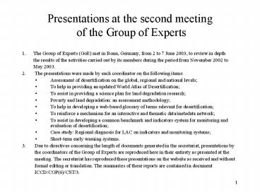
- 1. The Group of Experts (GoE) met in Bonn,
Germany, from 2 to 7 June 2003, to review in
depth - the results of the activities carried
out by its members during the period from
November 2002 to - May 2003.
- 2. The presentations were made by each
coordinator on the following items - Assessment of desertification on the global,
regional and national levels - To help in providing an updated World Atlas of
Desertification - To assist in providing a science plan for land
degradation research - Poverty and land degradation an assessment
methodology - To help in developing a web-based glossary of
terms relevant for desertification - To reinforce a mechanism for an interactive and
thematic data/metadata network - To assist in developing a common benchmark and
indicators system for monitoring and evaluation
of desertification - Case study Regional diagnosis for LAC on
indicators and monitoring systems - Short-term early warning systems.
- 3. Due to directives concerning the length
of documents generated in the secretariat,
presentations by - the coordinators of the Group of
Experts are reproduced here in their entirety as
presented at the - meeting. The secretariat has reproduced
these presentations on the website as received
and without - formal editing or translation. The
summaries of these reports are contained in
document - ICCD/COP(6)/CST/3.
2
Contents
- Page
- I. Assessment of desertification on the
global, regional and national levels (item 1.1)
3 - II. To help in providing an updated World
Atlas of Desertification (item 1.2) 25 - III. To assist in providing a science plan
for land degradation research (item 1.3) 72 - IV. Poverty and land degradation an
assessment methodology (items 3 and 1.6) 109 - V. To help in developing a Web-based
glossary of terms relevant for - desertification (item 1.4) 129
- VI. To re-enforce a mechanism for an
interactive and thematic data / meta - data network (item 1.5) 149
- VII. To assist in developing a common
benchmarks and indicators system - for monitoring and evaluation of
desertification (item 1.6) 160 - VIII. Case study Regional diagnosis for LAC on
indicators and - monitoring systems (item 1.6) 172
- IX. Short-term early warning systems (item
1.8) 211
3
Item 1.1 Assessment of Drought and
Desertification on the Global, Regional and
National Levels
Prof. Dr. Kazuhiko Takeuchi Department of
Ecosystem Studies Graduate School of Agricultural
and Life Sciences University of Tokyo Japan
Overview of the Assessment of Drought and
Desertification Several indicators have been
developed for assessing drought and
desertification however, effective benchmarks
are yet to be determined. A drought Early Warning
System (EWS) has already been established and
utilized for the prediction of drought through
modeling approaches. However, this is not
effective when considering countermeasures to
take account of the biophysical and
socio-economic information at the local level.
4
- Concrete methodology for desertification
assessment, particularly for developing
benchmarks and indicators of land
characteristics, has not been established. The
benchmarks and indicators for drought EWS and
desertification EWS are closely interrelated.
However, a standard methodological framework of
desertification EWS has not been realized due to
a lack of agreement on benchmarks and indicators. - The DeMon-I and II projects have developed
comprehensive modeling in Mediterranean regions
(Lacaze et al., 1996 Hostert, 2001). However,
there are no projects for model development in
other regions, such as Asia and Africa. It can be
said that there is no operational desertification
assessment model that can be utilized to assess
the effectiveness of countermeasures to combat
desertification. - Evaluating and Structuring Methodology for
Assessment of Drought and Desertification - 1.1. Objective of Drought and Desertification
Assessment - The assessment of drought and desertification is
a methodological framework for developing
guidelines for countermeasures to be used when
past and present conditions pass a threshold,
beyond which environmental fluctuations cause
serious damage to both the environmental and
human ecosystems. Each threshold should be
derived from the monitoring of natural and
anthropogenic impacts fluctuating from seasonal
to decadal time scales, and from local to global
spatial scales. - First, we consider drought assessment and
desertification assessment separately. Both have
some common problems, and common characteristics
of methodology for assessment. At the same time,
they have some different characteristics. Since
the time scale of drought is seasonal,
methodologies for the prediction of drought
occurrence and prevention are required, in short,
an early warning system for drought. On the other
hand, the time scale of desertification
assessment is from a few years to decades.
Long-term countermeasures are required for
prevention. The long-term prediction and
evaluation system is desertification EWS. - Both EWS's include common indicators such as
Normalized Difference Vegetation Index (NDVI),
rainfall fluctuation, vegetation cover, and
population pressure. On the other hand, crop and
livestock, food supply and consumption are more
important factors for drought prediction. Land
information and socio-economic issues are more
important when considering desertification
assessment (ICCD/COP(5)/CST/4, Table1).
5
Table 1. Characteristics of early
warning/monitoring systems for drought and
desertification (ICCD/COP(5)/CST/4)
6
1.2. Benchmarks and Indicators for Drought and
Desertification Assessment
- The report on benchmarks and indicators written
by the CST held by COP2 in 1998
(ICCD/COP(2)/CST/3/Add. 1) discusses the
following 5 points - (1) Establishing a procedure to collect
information, - (2) Developing the process of consultation and
selecting a set of global indicators, - (3) Promoting a mechanism to evaluate
applicability of indicators, - (4) Promoting institutional and technical
capacities, and - (5) Maintaining the consultative process.
- However, no indicators were proposed and were
reflected in the National Action Programmes
(NAPs). To develop indicators to be used in NAPs,
a case study has been performed for the southern
part of Africa Benchmarks and Indicators
Report of the Permanent Inter-State Committee on
Drought Control in the Sahel (CILSS) and the
Sahara and Sahel Observatory (OSS) on their
initiative on the development of benchmarks and
indicators (ICCD/COP(5)/CST/7). - That study examined the methodology of the
evaluation of monitoring to contribute to develop
impact and implementation indicators to NAPs. It
also proposed the development of common
indicators to enable inter-regional comparisons.
In the report, desertification assessment was
defined as the determination of the degree of
desertification and the monitoring of its
evolution. It should be emphasized that both the
monitoring of impact and the implementation
process are very important. - Moreover, it mentioned the Pressure-State-Response
(PSR) model, and the Driving forces-Pressure-Stat
e-Impact-Response (DPSIR) model, which is an
improved version of the PSR model. However,
concrete methodology was not clear, and
benchmarks were hardly discussed. Future
discussion of these points is needed.
7
1.3. Hierarchy of Drought and Desertification
Assessment
- Various systems of drought assessment have been
established at an international level. For
example, the Famine Early Warning System (FEWS)
developed by the United States (Gonzalez, 2001)
for peoples vulnerability to food insecurity,
and the Global Information and Early Warning
System on Food and Agriculture (GIEWS)
established by the Food and Agriculture
Organization of the United Nations (FAO), have
been made practicable. However, the spatial
resolution is insufficient for considering
countermeasures at national and local levels. It
is important to establish an organization to
apply such systems on national and regional
scales. - It is necessary for food security to evaluate the
socio-economic status of each region, as well as
macro indicators such as populations. Macro
environmental factors such as NDVI and
precipitation fluctuation have been used for
assessment on global and regional scales. It is
now time to develop indicators at national and
local scales and to monitor and assess them. - In terms of desertification assessment,
desertification maps and degradation maps on an
international scale have been published such as
Global Assessment of the Status of Human-Induced
Soil Degradation (GLASOD), but there is room for
argument about whether the methodology used was
objective or not. Therefore, more accurate
evaluation of desertification is required based
on scientifically credible procedures. Oldeman
and van Lynden (1998) explained that the concept
used in Soil Degradation Assessment for South and
Southeast Asia (ASSOD) has a more cartographic
base, and employing the concept of developing a
GIS-georeferenced soil degradation database. - The Group of Experts (GoE) will give special
attention to global desertification mapping. A
more serious problem is the lack of progress of
concrete discussions for practical
desertification assessment. Except for a few
examples, entire sequences of process,
information collecting, monitoring, assessment
and modeling of land information are still
lacking. The ad hoc panel on EWS proposed to CST
pilot studies for desertification EWS, on the
basis of understanding this problem
(ICCD/COP(5)/CST/4).
8
2. Review Criteria and Basis on Which Drought and
Desertification Assessment is Evaluated
- 2.1. Review of National Action Programs
- On reading the reports written in English and
open to the public on the UNCCD Web site we found
that only a few national action programmes
proposed indicators, benchmarks, assessments and
modeling. The Gambia, India and Kenya discussed
benchmarks. India, Kenya, Mongolia and Uzbekistan
discussed modeling. - The Gambia national report (1999) discussed the
benchmarks and indicators for measuring the
progress of implementation. They not only made
mention of the necessity of benchmarks and
indicators, but also defined the indicators,
baselines, targets and responsible party. The
indicators were classified into 3 categories
physical indicators, process indicators, and
process result indicators. Physical indicators
included items such as increasing forest cover
and reduction in bushfires. Process indicators
consisted of the indicators related to community
management such as increased community forest
management (CFM). Process result indicators
included the benefits that the community received
from the forest management and the participation
of the community in the forest management plan. - In the second national report of the Gambia
(2002), the benchmarks and indicators for
measuring progress were discussed again and a
matrix of indicators was proposed. The matrix of
indicators is divided into strategic objectives,
indicators and tools. The range of the discussion
of the matrix is (1) livestock and range
management, (2) agriculture, soil and water
conservation, (3) forestry, wildlife and
fisheries, (4) operational social dimensions, and
(5) institutional framework for NAP
implementation.
9
- The national report of Kenya (2002), which
recognized the effectiveness of Environmental
Information Systems (EIS) for the assessment of
land degradation, discussed both indicators and
benchmarks. A conceptual model of the
desertification process was proposed, in which
natural factors and human induced factors were
the major causes of desertification. In the
report, EWSs were also described concretely as
follows An EWS for drought and desertification
should go beyond just assessing and monitoring of
drought and desertification, to include
vulnerability and risk assessment and maps (NAP
Kenya 2002). - India also discussed benchmarks and indicators,
after mentioning EWSs, Land Degradation
Assessment in Drylands (LADA) and Millennium
Ecosystem Assessment (MA). They noticed that
Most countries, including India, do not use a
scientifically based and verifiable set of
benchmarks and indicators for monitoring and
assessing desertification. The Indian report
proposed criteria for selecting indicators taking
account of the characteristics of the impact and
implementation indicators. Moreover, the Indian
report stated that a benchmark should be used in
assessing trends over time. - The NAP of India (2001), which has the most
advanced scientific view, discussed the
methodology of the Assessment of resource
status through soil-weather modeling approach.
Based on the long-term experimental data, a
number of models were developed to predict the
effect of management/conservation practices on
crop yield and resource losses. - In the NAP of Uzbekistan (1999) the processes of
desertification were discussed in detail. The
factors of desertification consisted of natural
factors, anthropogenic factors, and their
interactions. On the other hand, it insisted that
the study of drought and desertification in the
future should consider the following points
degradation of vegetation cover, wind erosion,
water erosion, soil salinity, dehumification and
decrease of fertility, breach of the
water-physical properties of soil, accumulation
toxic contaminants in soil, influence of the
animals on soil degradation, influence of
anthropogenic factors, prognosis of drought,
influence of the climatic changes, and using of
wind and water power. For each of the 12 points
the Uzbekistan report determined the
corresponding leading scientific and educational
standards. - The Uzbekistan report also discussed the
possibility of modeling desertification (Figure
1). The distinctive feature of desertification in
Uzbekistan is frequent sand-dust storm
occurrences. Sand-dust storms accompanied by salt
damage the regions surrounding the Aral Sea. The
establishment of modeling methodology in these
regions must provide useful information to
neighboring regions such as China, Kazakhstan and
Mongolia, where sand and dust storms have
increasingly became a serious problem in recent
years.
10
Figure 1. Desertification processes in Uzbekistan
(NAP of Uzbekistan, 1999)
11
2.2. Thematic Program Networks (TPNs)
- In terms of Thematic Programme Networks (TPNs) in
Asia, TPN 1 to 6 were planned, TPN 1 to 4 have
been started, and TPN 5 launch meeting is to be
held in Mongolia in 2003. TPN 1, which is hosted
by China, aims at the monitoring and assessment
of desertification. The inaugural meeting was
held in Beijing, a related meeting was held at
the United Nations University in Tokyo, Japan,
and two more meetings were held in Beijing. In
the meetings the methodology of monitoring and
assessment, remote sensing in particular, was
mainly discussed. However, satisfactory outcomes
were not achieved. - Currently, TPN1 is editing manuals of the
indicators and benchmarks in Asia, as a
prerequisite of monitoring and assessment. Though
concrete indicators were proposed in TPN1,
hierarchical differences among indicators, and
the determination of benchmarks have not been
discussed yet. - On the other hand, TPN5 that will be hosted by
Mongolia aims at the mitigation of drought. The
possibility of establishing the first drought
early warning system in Asia will be discussed.
It is worth discussing the possibility of
desertification monitoring that includes land
conditions. It is also worthy combining the pilot
study proposed by the EWS ad hoc Panel on EWS
with the discussions included in TPN5.
12
2.3. Operational Drought and Desertification
Assessment Systems
- Drought Early Warning Systems
- The short-term EWSs for drought include drought
assessment at a basic level. For example, they
utilize indicators such as the following crop
status, food consumption, cultivation area,
rainfall, population density and NDVI. - The Famine Early Warning System (FEWS) is an
information system developed to prevent
starvation in sub-Saharan regions in Africa. FEWS
is monitoring the regions with a high risk of
food shortages that lead to starvation, and
evaluating the climate and crop data, to find out
which factors may have an effect on the food
status of the region. The core structure of FEWS
consists of monitoring and assessment. - The FAO Global Information and Early Warning
System (GIEWS) on Food and Agriculture monitors
the status of farm crops by utilizing rainfall
predictions on the basis of Meteosat, and
evaluates vegetation on the basis of NOAA/AVHRR.
This system also includes monitoring and
assessment as its core structure. Moreover, its
distinctive feature is model development that
integrates agro-climatic, socio-economic and
human health data. - Vulnerability Analysis and Mapping (VAM) operated
by the World Food Programme (WFP), which was
established to counteract unstable food supply
and disasters, outputs digital maps of analyzed
results. The FEWS and VAM satisfy the important
condition of assessment, that is, the analysis of
vulnerability risks. - Desertification Assessment
- FAO mentioned Overall Assessment of
Desertification (OAD), evaluated the current
status and the necessity of desertification
assessment, and pointed out the two following
problems. Firstly, existing national and
international data do not meet the present needs.
Though global data such as GLASOD and SOTER have
been utilized, they are not sufficient for
building policies at a regional or national
level, because the scale is less than one to ten
million. Also, socio-economic parameters of
desertification were not provided. Secondly,
methodology for assessing and modeling
desertification has not been completed.
13
- Land Degradation Assessment in Drylands
(LADA) and Millennium Ecosystem Assessment (MA) - Land Degradation Assessment in Drylands(LADA) and
Millennium Ecosystem Assessment (MA) are leading
the discussion of desertification assessment.
LADA is based on the collaboration of UNEP and
UNCCD. MA is a much broader assembly of
organizations, in which the UNCCD secretariat
participates. - LADA aims at the following objectives (i) to
provide basic, standardized information,
including maps, databases, etc. on the state of
land degradation, its causes, its impacts, to
combat land degradation, at national, regional,
and global levels, (ii) to develop methods for
land degradation assessment and monitoring at all
levels, including methods for use by national
organizations at local level, and (iii) to build
capacities at all levels to enable the design and
planning of interventions for mitigating land
degradation and establish sustainable land use
and management practices (ICCD/COP(5)/INF. 7). - MA covers existing assessments, and makes
evaluations by focusing on the multilevel and
holistic indicators and phenomena. MA focuses on
the assessment of existing data and literature
and also gives attention to the development of
some new indicators addressing the ecosystem
goods and services and their links to human well
being (MA methods, p5). - MA is expected to address the question How well
can scientists predict when threshold responses
of ecosystems (that is, sudden and dramatic
changes) might occur in response to species
losses, increased nitrogen input, or invasive
species? - The direct objectives of MA follow three themes
- (1) Systemization of the existing assessments,
- (2) Evaluation of response options and future
prediction, and - (3) Capacity building of human, institution and
organizational structures. - MA provides useful information from the viewpoint
of - (1) The objective of the increase in the total
benefit from ecological goods and services, and - (2) Providing choices useful for decision-makers
by evaluation of response options and future
predictions. - MA intends to discuss the multi-scale assessment
at global, regional and local levels.
14
2.4. Convention on Biological Diversity (CBD)
- According to the report summarizing the
biodiversity in arid and sub-humid lands
(UNEP/CBD/SBSTTA/7/4), six activities are
required for the assessment of desertification - The Convention on Biological Diversity (CBD) is
referred to for two reasons (1) The assessment
of desertification is a subject for discussion in
the Convention, and (2) One of the target
ecosystems in the Convention is drylands, whose
definitions are the same as that in the UNCCD. - (1) Assessment of the status and trends of
biodiversity in dry and sub-humid lands and the
effectiveness of conservation measures, - (2) Identification of specific areas of value
and/or under threat, - (3) Further development of indicators of the
biological diversity of dry and sub-humid lands
and its loss, for use in the assessment of status
and trends, - (4) Building knowledge on ecosystem functioning,
- (5) Identification of local and global benefits
of biodiversity and socio-economic impacts of its
loss, and - (6) Identification and dissemination of best
management practices (UNEP/CBD/ SBSTTA/7/4). - Moreover, this report mentioned the necessity of
a closer connection to the UNCCD. - A global biodiversity outlook is being prepared,
which to some extent, provides information at a
global level. However, the land degradation in
susceptible drylands was assessed utilizing the
data of GLASOD.
15
Table 2. Identified EO production for
desertification (Anonymous, 2002)
16
- 2.5. Hierarchy and Selection of Indicators
- When the CST reviewed the benchmarks and
indicators in the reports from the country
Parties (ICCD/COP(4)/CST/5) the secretariat noted
that there is an urgent need to develop
indicators capable of being used at the community
level and which are economically viable. - The proposal of the benchmarks and indicators
system for desertification monitoring and
assessment on the basis of the activity of TPN1
in the Asia region, described the benchmarks as
follows Benchmarks are the baseline that serves
a starting point for evaluation and monitoring
and thus provides the point of difference from
which the land starts to degrade/improve.
Benchmarks can be determined by identifying
non-degraded land ecosystems under the same
agro-climatic zone and natural conditions. - The report mentioned that the indicator system
should include the four aspects pressure,
state, desertification impact and implementation
to which the DSR and DPSIR frameworks seemed to
be applied. - For the selection of indicators at the broader
scale, we have to depend on satellite imagery and
statistical data. On the other hand, at a local
scale, it is important to collect field data from
field surveys and questionnaires. There exists a
certain relationship between the hierarchy and
the derived data. To realize drought and
desertification assessment it is necessary to
start with the good use of existing data. At this
point, the desertification monitoring which will
be launched by the Treaty Enforcement Services
using the Earth Observation (TESEO) project is
notable because of the full use of satellite
images, which will display data on climate,
hydrology and bio-physical conditions (Table 2).
17
3. Conclusions Drawn from the Methodology Review
and Review Criteria
- 3.1. Benchmarks and indicators
- The Possible Work Plan for Assessment by the GoE
states that The group might wish to establish
specific baselines and benchmarks using an
appropriate baseline year. It is urgent to
monitor and evaluate the trend of the indicators
of pressure, status, impact and implementation in
connection with those in a particular year. The
CST should intensively discuss this point in
relation to COP5. The NAPs reviewed in this
report obviously lack such a viewpoint. - To solve this problem, the trend data should be
collected intensively, and model stations for
monitoring the trend of indicators should be
established. Such stations must also contribute
by examining the methodology of the collection of
local data.
18
3.2. Possibility of Modeling in Drought and
Desertification Assessment
- Modeling for drought assessment at global and
regional levels has been established. In the
future, it is necessary to develop them into
holistic assessments by incorporating
socio-economic factors and population conditions
as well as political and religious conditions. - In developing countries establishment of drought
assessment at national and local levels is
constrained by low economic and technological
levels. Especially at the local level, getting
access to information itself is difficult. The
development of methodology to solve these
problems is an important task. The more local the
target scale becomes, the more important it is to
analyze natural, social and human factors, which
are distinctly different from those at global
scale. Therefore, the development of suitable
indicators for the local level is required. - Establishment of modeling for assessment at the
national and local levels depends on solving the
problems such as difficulty in collecting and
analyzing data caused by the low economic and
technological levels in developing countries.
Financial and technological assistance from
developed countries to developing country is a
critical need that must be considered when
investigating this problem. - In terms of desertification assessment at a
global level, improvement of the scientific
accuracy of GLASOD, and starting revision
activities on the basis of improved
methodologies, are particularly important. The
global evaluation of land and water resources is
especially necessary to achieve the objective of
understanding land degradation. - CILSS in the western part of Africa, OSS and TPN1
in the Asian region are existing examples of
desertification assessment at a regional level.
However, they are limited to the stage of
proposal of indicators. More effort is needed to
determine benchmarks, to build models by
combination of the indicators, and to evaluate
the effectiveness of the implementations by
simulations. - A general model including as much land and human
information as the case studies of the DeMon-I
and II projects provide, should be applied to
Africa and Asia. Each regional group should
discuss and build specific models at regional
levels, based on the global model (Figure 2)
19
Figure 2. Flowchart of the SEMMED model (de Jong,
1999)
20
Local Indicators for Drought Assessment
- Many of the experts agree that there are several
aspects and facts to be taken into consideration
in any complex evaluation or assessment of
drought events the most important are as
follows - 1) Climatic factors (development and trends)
expressed by real meteorological data, - 2) Local hydrological/hydrographical data (mainly
on precipitation and evapotranspiration, but also
information on groundwater and surface water flow
conditions), - 3) Soils (classification and present state of
endangerments), - 4) Vegetation and land use, and
- 5) Economic evaluation of present agricultural
use and looming trends due to global change. - Drought threat assessment has to deal with
natural site-relevant factors and agricultural
production practices as well as socio-economic
evaluation of agricultural production and its
impact on regional development. Certain aspects
of land use and yield capacity might impose a
threat of drought to one region but could be a
favored impact for another region. - When expressing the result of an evaluation there
are two main methods that can be followed 1)
creating an integrating indicator taking into
account all the above mentioned aspects, or 2)
finding a method for the combination of different
factors and data on an areal basis (e.g. using
maps for the illustration of the spatial
distribution of the different factors and putting
these maps together with GIS techniques). In the
case of development of drought sensitivity maps
in a country or region we prefer the second way,
but intensive research work is needed.
21
3.3. P-D-S-I-R Framework and Modeling
- The Millennium Ecosystem Assessment divided their
assessment into three components - (1) condition and trend assessment,
- (2) scenario assessment, and
- (3) response assessment.
- Ordinary status indicators and benchmarks as well
as implementation indicators and benchmarks
correspond to both the condition and trend
assessment, and the response assessment. The MAs
proposal of the necessity of the scenario
assessment is noteworthy. The scenario
assessment, which predicts how the possible
policies affect the current trend, must provide
useful information for decision making when
considering various backgrounds. Despite
evaluation based on the prediction of the
condition and trend assessment, in which large
uncertainty may exist, it provides useful
information for ordinary people to help them
decide whether a policy should be supported or
not, by understanding the fluctuation range of
the prediction and the potential consequences of
the decision.
22
Figure 3. A framework for EWS on desertification
(Kar and Takeuchi, 2001)
23
- References
- Anonymous (2002) Treaty enforcement services
using earth observation desertification.
Obtained from http//styx.esrin.esa.it5000/teseo/
es_d.pdf - de Jong, S. M., Paracchini, M. L., Bertolo, F.,
Folving, S., Megier, J., de Roo, A. P. J. (1999)
Regional assessment of soil erosion using the
distributed model SEMMED and remotely sensed
data. Catena, 37, 291-308. - Gonzalez, P, (2001) Advances in desertification
monitoring and drought early warning. In Global
Environmental Forum, eds. Report of Ad Hoc Panel
Meeting on Early Warning System, held in
Yamanashi, Japan, June 4-8. 143-161. - Hostert, P. (2001) Remote sensing driven early
warning system for desertification and land
degradation, results and conclusions from
DeMon-II an integrated approach to assess and
monitor desertification processes in the
Mediterranean basin. In Global Environmental
Forum, eds. Report of Ad Hoc Panel Meeting on
Early Warning System, held in Yamanashi, Japan,
June 4-8. 163-169. - Kar, A. and Takeuchi, K. (2001) Towards an early
warning system for desertification. . In Global
Environmental Forum, eds. Report of Ad Hoc Panel
Meeting on Early Warning System, held in
Yamanashi, Japan, June 4-8. 163-169. - Lacaze, B., Caselles, V., Coll, C., Hill, J.,
Hoff, C., de Jong, S., Mehl, W., Negendank, J. F.
W., Riezebos, H., Rubio, E., Sommer, S., Filho,
J. T. and Valor, E. (1996) DeMon Integrated
Approaches to Desertification Mapping and
Monitoring in the Mediterranean Basin. Final
Report of the Demon-1 Project. ECSC-EC-EAEC,
Brussels/ Luxembourg, 165pp. - Oldeman, L. R. and van Lynden, G. W. J. (1998)
Revisiting the Glasod Methodology. In Lal, R.,
Blum, W. H., Valentine, C. and Stewart, B. A.
eds., Methods for Assessment of Soil Degradation.
CRC Press, Boca Raton/ London/ New York/
Washington D. C., 432-440. - Reid, W., Ash, N., Benett, E., Kumar, P., Lee,
M., Lucas, N., Simons, H., Thompson, V. and Zurek
M. (2002) Millennium Ecosystem Assessment
Methods. Obtained from http//www.millenniumassess
ment.org/en/publications/methods.pdf
24
Cited National Action Programmes and National
Reports
- India, 2001, National Action Programme to Combat
Desertification. Vol.1, Status of
Desertification. 294pp. - Kenya, 2002, National Action Programme A
Framework for Combating Desertification in Kenya.
55pp. - The Gambia, 1999, National Report on the
Implementation of the United Nations Convention
to Combat Desertification. 45pp. - The Gambia, 2000, National Action Programme to
Combat Desertification. 85pp. - The Gambia, 2001, 2nd National Report on the
Implementation of the United Nations Convention
to Combat Desertification. 27pp. - Uzbekistan, 1999, National Action Programme to
Combat Desertification in Republic of Uzbekistan.
125pp.
25
Item 1.2 To Help in Providing an Updated
World Atlas of Desertification(First Progress
Report)
- Prof. Dr. Laszlo Vermes
- Szent Istvan University, Faculty of Horticultural
Sciences - Hungary
26
1. Aim of the task
- determined at the Hamburg meeting of GoE as
follows - review the current status of mapping and the
Atlas itself - determine the criteria on what basis the new
Atlas can be accomplished - prepare recommendations for the terms of
reference and development of mapping the
vulnerability/sensitivity of areas by drought and
desertification
27
2. Short overview on the World Atlas of
Desertification
- 2.1 Background
- First World Map of Desertification 1977, by
FAO/UNESCO/WMO, UN Conference on Desertification,
Nairobi, Kenya - 1987 FAO/UNEP/UNESCO provisional methodology
for the assessment and mapping of desertification - 1987-1990 first global assessment of
human-induced soil degradation GLASOD
28
2.1 Background (cont.)
- 1992 First edition of the World Atlas of
Desertification UNCED, Rio de J., Brazil - 1995 UNCCD signed in Paris, France
- 1997 Second and present edition of the World
Atlas of Desertification UNEP, compiled by Nick
Middleton and David Thomas Preface was written
by Elizabeth Dowdeswell, Executive Director of
UNEP
29
2.2 Objectives
- The objective or aim of the Atlas was not defined
clearly in the publication - In the Preface designed for those working on
desertification at the global, regional and
national levels - and it is intended to facilitate the work of
governments at the Conference of the Parties of
UNCCD, and it is aimed to a wider audience - the global problem of desertification maybe
this is the key to understand the objective
30
2.3 Content
- Introduction provides the background and
information needed to explain the technical basis
of the Atlas - Section 1 presents the best available global
assessment of desertification and related issues.
It is devoted to the relationships between
climatic factors and desertification
31
2.3 Content (cont.)
- Section 2 presents the higher resolution GLASOD
survey of human-induced soil degradation in
Africa provides examples on the complexities of
the interrelationship between degradation causes
and effects - Section 3 (totally new) incorporates a number of
methodological developments, mainly deals with
ASSOD assessment of Asia, where greater emphasis
is given to generating assessment in country
level rather than at regional
32
2.3 Content (cont.)
- Section 4 (also new) highlights the
interlinkages between desertification and other
global environmental issues (soil salinization,
climate change, carbon sequestration, biological
diversity) and social dimensions (human
population and migration, socio-economics) it
contains also success stories in combating
desertification (China, Australia, Sahel). A
World Overview of Conservation Approaches and
Technologies (WOCAT) is given in form of case
studies.
33
2.4 Boundaries, difficulties, critical
remarks
- Database accurate and reliable data on the
extent and severity of desertification and the
rate of its progress, based on actual ground
survey, are very scarce. The existing data are
often controversial and open to doubts and
criticism. Available data are uneven in scale
and accuracy, therefore it is difficult to create
an accurate map as well.
34
2.4 Boundaries (cont.)
- Inconsistencies in the concept and the
definitions used Basic definition is complex
and simplifying at the same time, making
practically an equal sign between desertification
and human-induced land degradation in drylands
investigations are narrowing down to the arid,
semi-arid and dry sub-humid climatic zones.
35
2.4 Boundaries (cont.)
- Global approach to the problem adequate
assessment and consequent plans to counteract the
problem can only be usefully carried out at the
local scaleAdvantage is that it allows
desertification to be evaluated relative to other
global environmental issues, like global warming,
climatic change, biological diversity, etc.
36
2.4 Boundaries (cont.)
- It was useful to develop a world-wide picture to
identify hotspots at the continental, national
and local scales for this reason the Atlas was
organized to start from a global perspective
(Sections 2 and 3), and tried to give some
examples in greater detail and in smaller
scales specific issues of particular importance
(Section 4).
37
2.4 Boundaries (cont.)
- The scale itself can be a source of mistake by
the very high scale of a global map a map-unit
with an overall high degradation/desertification
severity may be characterized as such because
moderate degradation/desertification process
occur in a relatively large part of the unit, and
vice versa that means an entire polygon is
coloured on the map according to a particular
characteristic does not necessarily show that all
the land within this unit possesses that
characteristic.
38
2.4 Boundaries (cont.)
- The Atlas does not deal with drought problems,
however this phenomenon affects great areas all
over the world, and can be a preceding factor to
desertification not only in the so-called
susceptible drylands.Assessment and mapping of
drought events and sensitivity can be made
effectively only in local or regional scale.
39
3. Needs for mapping
- 3.1 Needs for mapping the spatial distribution of
desertificationa) providing general information
to the public - b) general information for research
activities - c) general information for education purposes
- d) some basic (general) information for
decision - makers and organizers interested in
- preparedness and mitigation actions
40
3. Needs for mapping (cont.)
- Mapping should be made in different scales,
according to real objective of the evaluation
possibilities, the available databases and the
concrete aims of the use of the map. - The maps and evaluations drawn on global data and
assessment should be broken down to regional
and/or local scales showing a more accurate
distribution of the characteristics.
41
3. Needs for mapping (cont.)
- 3.2 Needs for mapping the spatial distribution
of drought sensitive areasa) detailed and site
specific information for decision makers and
organizers - b) detailed information to local people
effected by drought impacts - c) specified information for research
activities on drought mitigation - d) specified information for education
purposes
42
3. Needs for mapping (cont.)
- Analyses and mapping have to be made first in
smaller (local or national) scale, taking into
consideration the concrete aim of the mapping,
the available databases, and using local, but
generalized and internationally comparable
indicators, and on the basis of these local maps
should be the regional or global map compiled as
a second step.
43
4. Main aspects of a more detailed and complex
mapping methodology
- The following aspects should be combineda)
climatic (hydro-meteorological) data and indexes
are of basic importance, but not enough for the
expression and characterization of the processes
of a certain area
44
4. Main aspects (cont.)
- b) other ecological aspects should be taken
- into consideration, like- hydrological
(groundwater and surface - water flow) conditions
- - soil and topography of the area
- - crop cover (vegetation) conditions
- - relating trends of global changes
45
4. Main aspects (cont.)
- c) other human/social facts should be taken into
account, like - land use - - population density
- - economical evaluations
- Therefore a new approach, new methodology and new
databases are necessary for a better mapping
process
46
5. Project proposal for the implementation of
the new mapping concept
- January 2003 a group of European (mainly CEE)
countries decided to create a consortium and to
make a project proposal to EU FP6 on the
Development of the European Drought Sensitivity
Map as a first step and a pilot study for the
implementation of the new mapping concept. (19
participants including FAO and WMO)
47
5. Project proposal (cont.)
- Main aim of the proposed research work is to
elaborate the common methodology and with the
help of that construct and draw the drought
sensitivity map in those countries who are ready
to work together in the frame of a specially
targeted research project. - The aim of the consortium is to solve the
expression of the drought sensitivity of an area
as complex as possible and to find out the method
of its illustration on a map.
48
5. Project proposal (cont.)
- Drought severity shows the strength or intensity
of a special drought event through the deviation
of the moisture condition (supply) from the mean
value at a specific location, using some of the
meteorological or hydro-meteorological indexes
for numerical expression of water scarcity.
49
5. Project proposal (cont.)
- Drought sensitivity means the distribution of
the spatial occurrence/appearance of differently
severe droughts in an area or region, based not
only on the long-term data of relevant
hydro-meteorological indexes, but including
among others also information of soil
characteristics and plant tolerance. The areal
distribution of drought severity is changing year
by year, but drought sensitivity remaining more
constant.
50
5. Project proposal (cont.)
- Drought vulnerability is expressing
characteristics of population, activities, or the
environment being susceptible to the effects of
drought its degree depends on the environmental
and social characteristics of the region and is
measured by the ability to anticipate, cope with,
resist and recover from drought.
51
5. Project proposal (cont.)
- In the first phase of the research work a
scientifically based, clear and practically used
mapping methodology will be developed. In the
second phase each participating country has to
start with the construction and drawing their own
drought sensitivity maps, and these will be put
together creating the European one.
52
5. Project proposal (cont.)
- First benefit the maps are important tools in
the hand of everybody who has some role in the
drought mitigation processes - Second advantage is the resulted country maps
can be combined, easily creating this way the
drought sensitivity maps for the whole continent,
and the methodology is ready for use in all
interested countries
53
6. Summary and recommendations
- The World Atlas of Desertification edited by
UNEP, 1997, is an important and considerable
trial to summarize global information on the
process of desertification and land degradation
in the drylands, to present an overview on these
lands, and to draw attention of all people and
governments in the world to the problems
accompanying desertification.
54
6. Summary (cont.)
- Because of the lack of accurate and reliable
data, the lack of clear determination of aims and
objectives, and because of the originally
selected global approach, there are some
limitations in the use of this Atlas, and there
is a definite need for revising and further
development of it. Taking into account the
overall criticism of the existing Atlas, and also
the suggestions of experts in the field of
assessment and mapping of drought and
desertification, the followings should be
discussed and recognized.
55
6. Summary (cont.)
- a) As a first step it is recommended to identify
the target audience for the Atlas and to
elaborate the mechanism of dissemination.
Accessibility is an important consideration.
56
6. Summary (cont.)
- b) The objectives of compilation and constructing
a new edition of the World Atlas have to be
determined clearly before the revision work will
start. The well settled aim of the Atlas will
influence or even determine the approach, the
scale, the method of construction, and result in
a better defined and more effectively used
publication.
57
6. Summary (cont.)
- c) A new and separate methodology of assessment
and illustration of drought and desertification
should be worked out, based on more accurate
local databases and national scale of evaluation,
and using a bottom-up type of construction. - d) Complexity of the topic and influences of many
aspects should be taken into consideration,
therefore it is necessary to find out a method
for the combination of the different factors and
data on an areal basis.
58
6. Summary (cont.)
- e) A revision and possibly new determination of
basic terms and concepts is urgent, especially
making distinction between drought and
desertification, and a set of indicators
(indexes, benchmarks) should be selected in both
cases with the help of which the evaluation and
expression of the main processes or results could
be made.
59
6. Summary (cont.)
- f) One of the main drawback of the existing World
Atlas is that paper cartography in general is
quite static and becomes quickly obsolete,
therefore it is strongly recommended to use a
more GIS-based approach. According to the opinion
of different experts the role of GIS should be
central for mapping from several practical and
data management points of view.
60
6. Summary (cont.)
- g) For creating a new concept and establishing a
new methodology of assessment and mapping of
desertification and drought sensitivity, a
smaller ad hoc team should be organized in the
frame of the GoE with the participation of the
coordinators of the tasks 1.1, 1.2, 1.4, 1.5,
1.6, 1.8 and 1.9. This ad hoc team has to prepare
a second progress report answering all the
problems mentioned above, and work out a proposal
for the further development of the Atlas.
61
6. Summary (cont.)
- Concrete work plan of the ad hoc team could be
elaborated during the second meeting of GoE in
Bonn - h) Altogether 30 expert months are needed as a
basis for financing the work of the ad-hoc team.
62
6. Summary (cont.)
- i) The Group of Experts supports the efforts of
the European countries to construct and draw the
European drought sensitivity map, and promotes
the acceptance of the project proposal having
been prepared on this topic and sent to the
European Union FP6 Research and Development
Programme.
63
6. Summary (cont.)
- ProposalMain reasons for the establishment of
the proposed ad hoc team are as follows - For the assessment and also for mapping of
desertification and drought we should have - -- final selected indicators (indexes) and/or
benchmarks for numerical expression of severity
or sensitivity ? Task 1.6 ? Ms. Elena Abraham
64
6. Summary (cont.)
- -- clearly determined terms (concepts) related
to desertification and drought ? Task 1.4 ? - Dr. Ryszard Debiczki
- -- summarized review criteria, including the
structure and methodology of assessment ? Task
1.1 ? Dr. Kazuhiko Takeuchi - -- to take into account the short- and
long-term early warning systems used ? Task
1.8/1.9 ? - Dr. Victor Castillo Sanchez
65
6. Summary (cont.)
- -- it is also necessary to take into
consideration the mechanism for an interactive
and thematic data/metadata network ? Task 1.5 ? - Dr. Maurizio Sciortino
- Aim (and name) of the ad hoc team will be
Developing the preparatory suggestions for the
revision of the World Atlas of Desertification
and for elaboration of a new one
66
6. Summary (cont.)
- For the assessment and mapping methodology
important points to be discussed, clarified,
developed and making decision on them are as
follows - (1) objectives
- (2) scales (spatial and temporal)
- (3) basic indexes used (hydrometeorological)
67
6. Summary (cont.)
- (4) other aspects to be involved and form(s) of
- their expression and involvement
- (5) common (unified) methodology for
- evaluation and mapping
- (6) clear determination of terms (definitions),
- at least of basic importance
- (7) making institutional connection to LADA
- and MA projects, and to others
68
Appendix 1 Definitions
- Desertification is land degradation in arid,
semiarid and dry subhumid areas resulting from
various factors, including climatic variations
and human activities (UNCED, Rio, 1992 included
in UNCCD, 1995)The basic indicator of
desertification in the Atlas is human-induced
soil degradation. It is often very difficult to
separate natural processes of land degradation
from those resulting from human activities.
69
Appendix 1 Definitions (cont.)
- Land in this context includes soil and local
water resources, land surface and vegetation,
including crops. - Degradation implies reduction of resource
potential by one or a combination of processes
acting on the land. - Arid, semiarid and dry subhumid climatic zones
are collectively referred as the susceptible
drylands. Hyperarid zones, the true deserts, are
not considered as susceptible drylands.
70
Appendix 1 Definitions (cont.)
- Drought is not defined in the Atlas. According to
other definitions (ICID, 1998) drought is a
deficiency in precipitation from expected or
normal that when extended over a season or
longer period of time is insufficient to meet
demands. This may result in economic, social, and
environmental impacts. It should be considered as
a recurrent feature of climate.
71
Appendix 1 Definitions (cont.)
- Drought is a relative, rather than absolute
condition that should be defined for each region
and for each group of living organisms (not only
plants). Each drought differs in intensity,
duration, and spatial extent. From agricultural
points of view drought is the permanent and
considerably high water shortage of a given plant
stand on a given agricultural and/or forest area,
which limits the life-processes of the plants to
a great extent. Drought can not be interpreted
without plants, because different plants have
different answers to the same degree of dryness
or water scarcity.
72
Item 1.3To assist in providing a science plan
for land degradation research
- Prof. Dr. Olatunji Folorunso
- Department of Soil Science
- Faculty of Agriculture, University of Maiduguri,
Nigeria
73
MEMBERSHIP
Prof.Dr. Olatunji A. Folorunso Coordinator Prof.D
r. Laszlo Vermes Member Prof.Dr. Lixian Wang
Member
TERMS OF REFERENCE
- Review and prioritize current research
activities (2003) - Identify and prioritize new research needs
(2004) - Identify sponsor for international and regional
- programmes (2005)
- Draw up comprehensive report (2006)
74
SCIENCE-PLAN FOR LAND DEGRADATION
RESEARCH (A) Review and Prioritization of Current
Land Degradation Research Activities REGION
.. COUNTRY..
75
SCIENCE-PLAN FOR LAND DEGRADATION
RESEARCH (B) Identification and Prioritization of
New Research Needs REGION.. COUN
TRY..
76
AFRICA
77
SCIENCE-PLAN FOR LAND DEGRADATION
RESEARCH (A) Review and Prioritization of Current
Land Degradation Research Activities REGIONAfri
ca.. COUNTRYNigeria..
78
Table (cont.)
79
ASIA
80
SCIENCE-PLAN FOR LAND DEGRADATION
RESEARCH (A) Review and Prioritization of Current
Land Degradation Research Activities REGION
Asia COUNTRY JAPAN
81
(No Transcript)
82
(No Transcript)
83
(No Transcript)
84
(No Transcript)
85
(No Transcript)
86
(No Transcript)
87
(No Transcript)
88
(No Transcript)
89
(No Transcript)
90
(No Transcript)
91
(No Transcript)
92
(No Transcript)
93
(No Transcript)
94
(No Transcript)
95
(No Transcript)
96
(No Transcript)
97
(No Transcript)
98
(No Transcript)
99
(No Transcript)
100
(No Transcript)
101
CEE
102
II. Karcag Research Institute of the Debrecen
University, Hungary II/1. A Elaboration of
complex soil protection system to stop the
accelerated degradation and wind erosion of the
soils of the Great Hungarian Plain B - Karcag
Research Institute of the Debrecen University,
Karcag - Debrecen University, Faculty of
Sciences, Debrecen - Forestry Research
Institute, Puspokladany C see title D 1991 E
1993 F Ministry of Agriculture, Hungary G -
Determination of physical and chemical parameters
of soil s influencing their susceptibility to
wind erosion Determination of susceptibility of
different soil types to wind erosion Elaboration
of soil reclamation method using industrial
by-products to improve soil structure Elaboration
of the afforestation plan of Hajdu-Bihar
County H - II/2. A Determination of the
susceptibility of different soil types to
crusting B Karcag Research Institute of the
Debrecen University, Karcag C see title D
1998 E 1998 F Ministry of Agriculture,
Hungary G Elaboration of a process based on
quantified parameters to test different soil
reclamation methods aiming the improvement of the
physical properties of the soil H - II/3. A
Scientific establishment of moderation of drought
damages in the Great Hungarian Plain revealing
water regime features of field ecosystems B
Karcag Research Institute of the Debrecen
University, Karcag C see title D 1997 E
2000 F National Science and Research Fund
(OTKA) G - Quantification of the effects of
different soil cultivation operations on water-
and temperature regime of the soil Elaboration of
the technological elements of moisture preventing
soil cultivation
103
II/4. A Modernization of parametrisation systems
promoting soil utilization and reclamation
decisions for rational use of salt affected
soils B - Karcag Research Institute of the
Debrecen University, Karcag - RISSAC,
Budapest C see title D 1997 E 2000 F Ministry
of Agriculture, Hungary G - Prediction of
dynamics of soil parameters determining soil
fertility of salt affected soils taking the
expectable climatic tendencies into
consideration Verification of a climate-soil-soil
fertility model for salt affected
soils Determination of the necessary reclamation
measures for different utilization alternatives
of salt affected soils H - II/5. A
Examination of less fertile lands loaded with
wastewaters of communal origin B - Karcag
Research Institute of the Debrecen University,
Karcag RISSAC, Budapest C Study the
environmental effects of deep-furrow irrigation
with wastewaters D 1996 E 2001 F Ministry of
Agriculture, Hungary G New data were gained
concerning the loadibility of less fertile
ploughland III. Szent Istvan University,
Godollo, Hungary III/1. A Connections between
irrigation and salt regime of soils in the Great
Hungarian Plain B Department of Soil Science and
Agro-chemistry of the Godollo University C Study
the changes in salt regime of soils due to
irrigation D 1960 E 1969 F Ministry of
Agriculture, Hungary G Determination of salt
accumulation in soils due to intensive irrigation
and by irrigation water with different quality H
-
104
III/2. A Wind erosion and its damages in
Hungary B Department of Water Management and
Land Reclamation of the Godollo University C
Study the effects of wind erosion on different
soils of Hungary D 1981 E 1984 F Ministry of
Agriculture, Hungary G Determination of the wind
erosion sensitive areas in the country H
- III/3. A Research for establishing
protection against erosion B Department of
Landscape Ecology of the Godollo University C
Study the land use type on soil erosion D
1996 E 1997 F Ministry of Agriculture,
Hungary G Determination of harmful effects of
arable land and vineyards on erosion potential of
soils H - III/4. A Examining the K-factor of
the Wischmeier-Smith USLE model with GIS based in
situ research B Department of Landscape Ecology
of the Godollo University C Applicability of
soil erodibility factor D 1998 E 2001 F
Ministry of Agriculture G K-factor must be
examined and determined on the field before using
the model H - III/5. A Examining soils
susceptibility to erosion B Department of
Landscape Ecology of the Godollo University C
Examination of soil e
Recommended
CrystalGraphics Presentations


