
Hydrogeomorphic PowerPoint PPT Presentations
All Time
Recommended
THE HYDROGEOMORPHIC APPROACH TO FUNCTIONAL ASSESSMENT FOR PIEDMONT SLOPE WETLANDS B. Vasilas, UD; L ... Variability due to position of groundwater discharge sites; ...
| PowerPoint PPT presentation | free to download

2. Geomorphology, Hydrology, and Vegetation of Near-channel Flood Plain ... forests constitute 15-20% of the timberland in the Southeast and continue to be ...
| PowerPoint PPT presentation | free to view

... easements, 30-year easements and 10 year restoration cost share agreements ... Photo: Marion Jackson. Riverine. Lacustrine. Palustrine. Hydrogeomorphic ...
| PowerPoint PPT presentation | free to view
Constructing Activities Based on Grand Challenges Michael Wysession Washington University St. Louis, MO
| PowerPoint PPT presentation | free to download

Eastward tilting = 1 x 10⁻⁸ rad/yr (Adams, 1984) ... 2001 Environmental Science Institute: Bryan Dutton (Biology), Pete Poston ...
| PowerPoint PPT presentation | free to download
Chesapeake Bay Program Model Update Rich Batiuk Associate Director for Science U.S. EPA Chesapeake Bay Program Everything You Ever Wanted to Know about Chesapeake Bay ...
| PowerPoint PPT presentation | free to download

Title: Riparian PFC What It Is And What It Is Not Author: sswanson Last modified by: lsaito Created Date: 11/25/2002 4:13:04 PM Document presentation format
| PowerPoint PPT presentation | free to download

... (star) is compared to the mean of all previously constructed wetlands (green) ... The trajectory approach shows great promise. ...
| PowerPoint PPT presentation | free to view

AN OVERVIEW OF THE WETLANDS REGULATORY PROCESS AS IT RELATES TO THE PROPOSED OCEAN SPRINGS HIGH SCHOOL PROJECT A brief overview of the definitions, regulations and ...
| PowerPoint PPT presentation | free to view

Development of Multi-tiered Wetland Assessment Methods for Monitoring ... Most of loss due to ditching. and channelization and. direct conversion to ag of ...
| PowerPoint PPT presentation | free to view

Utilize most recent aerial photography for photo interpretation prior to sampling: ... can include native species need to create or review list of invasives) ...
| PowerPoint PPT presentation | free to view

Coyote Creek Watershed Integrated Pilot Assessment Santa Clara Valley Urban Runoff Pollution Prevention Program Coyote Creek and Watershed Stewardship Objectives are ...
| PowerPoint PPT presentation | free to view

The Resource Lands Assessment of the Chesapeake Bay Watershed
| PowerPoint PPT presentation | free to download

A Decision Support System (DSS) for Amazon Conservation Planning Identification and Prevention of Potential Impacts of Infrastructure Development
| PowerPoint PPT presentation | free to download
SWOT and Water Management * * * * * * * * * * * * * * * SWOT and Water Management Water Management: Keeping everyone happy With better data (forecasts) we can ...
| PowerPoint PPT presentation | free to download

This illustrates how the linkage of a surface hydrology model to a biogeochemistry model can be used to predict the filtering action of soils & vegetation as ...
| PowerPoint PPT presentation | free to download

David W. Hulse1, Stanley V. Gregory2, Warren B. Cohen3, Blake E. Feist4, and ... Anadromous fish distribution. by correlating woody vegetation within 120 m of ...
| PowerPoint PPT presentation | free to view

Aquatic Entomology ZOOL 484/584 Policies Course outline - website What is Aquatic Entomology? Study of Aquatic Insects, habitat consists mainly of a body of water ...
| PowerPoint PPT presentation | free to view

Great Lakes Coastal Wetlands Consortium: Inventory and Mapping. Ric Lawson. GLCWC Coordinator ... Consortium determined the inventory to be a priority need ...
| PowerPoint PPT presentation | free to view

... four per measurement sample plot Foliar Nutrients ... 12 trees per plot Stand Management Cooperative History Regional Forest Research Nutrition Project ...
| PowerPoint PPT presentation | free to view

Wetlands are delineated primary so that property owners will know which parts of ... Emphasis on cropped wetlands. Wetlands Reserve Program (WRP) ...
| PowerPoint PPT presentation | free to view

Protected Embayment. Sand-Spit Embayment. Lacustrine Wetlands. Protected Lacustrine ... Geomorphic Differences: Protected Lacustrine Embayment ...
| PowerPoint PPT presentation | free to view

Aspectos hidrogeol gicos de la relaci n aguas subterr neas superficiales en ... a la din mica litoral. Humedales de Punta Entinas y Salinas de Cerrillos. Tomado de ...
| PowerPoint PPT presentation | free to view

The Lagoon Water Quality Is Impaired. Upstream Freshwater Inputs Are Significant ... Inlet, Dredging and Disposal, Beach Nourishment, Berms, Culverts, Nesting Islands ...
| PowerPoint PPT presentation | free to view

Wavelet-based multifractal formalism (Muzy et al., 1993; Arneodo et al., 1995) CWT of f(x) ... The multifractal formalism (Parisi and Frisch, 1985) allows this ...
| PowerPoint PPT presentation | free to download

Functional assessment of each HGMU and production of maps ... geese. Additionally nutrients can. return to the system in the form of. excrement. ...
| PowerPoint PPT presentation | free to view

(Copied from M. Kirkby, Hillslope Hydrology) Outline. Introduction ... Models for soil pipe hydrology by Jones and Connelly (2002); Barcelo and Nieber (1982) ...
| PowerPoint PPT presentation | free to view

... levels of potential impact of human activities on specific functions of waters ... Vulnerability changes caused by proposed permit activity ...
| PowerPoint PPT presentation | free to view


The Reality and Challenge of Climate Change
| PowerPoint PPT presentation | free to view

Opportunities and Challenges for Accurately Documenting the Distribution of Aquatic Biota
| PowerPoint PPT presentation | free to view

In category 1 and 2 CARAs, lots less than 1 acre must use special on-site septic systems ... Townsend's big-eared bat. Vaux's swift. Red tailed hawk. SPECIAL ...
| PowerPoint PPT presentation | free to view
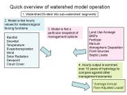
Quick overview of watershed model operation 1. Watershed Divided into sub-watershed segments Rainfall Snowfall Temperature Evapotranspiration
| PowerPoint PPT presentation | free to download

Iowa Wetland Mitigation Bank, Inc.