Maps and images distances between tube stops BBC - PowerPoint PPT Presentation
Title:
Maps and images distances between tube stops BBC
Description:
display by contours over a world map. and pixels. contours. pixels. Sea surface height ... map(), persp(), polygon() computational geometry. point in polygon ... – PowerPoint PPT presentation
Number of Views:48
Avg rating:3.0/5.0
Title: Maps and images distances between tube stops BBC
1
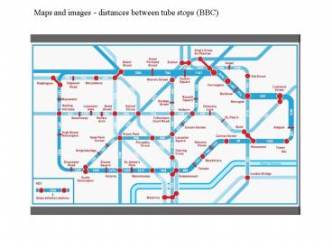
Maps and images - distances between tube stops
(BBC)
2
NY Times 01/26/09
3
NY Times 01/27/09
4
Spatial process data.
(s,t) geographic coordinates, e.g.
(latitude, longitude), (x-coord,y-coord) y(s,t)
real-valued e.g. available for s0,...,S-1
t0,...,T-1 How to display?
5
Starkey Reserve, Oregon - elk, deer, cows, humans
6
Example. Height of 500mb surface S64, t32
1200 GMT January 1, 1986 data based on many
observations, interpolated to grid display
by contours over a world map
and pixels
7
contours
8
pixels
9
Sea surface height
10
Stacking. Galton - photos of faces
electron micrographs crystal,
purple membrane 160 "units"
?j1160 yj(s,t)/160 stacking via FFT
11
(No Transcript)
12
Data may be aggregate, e.g. over polygons
coordinates of vertices choropleth plot a
thematic map in which areas are shaded
perspective plot hidden lines map(),
persp(), polygon() computational
geometry point in polygon Saskatchewan
births, counts, rates
13
(No Transcript)
14
(No Transcript)
15
Contouring.
Contour line, ?, (a function of two variables),
is a curve connecting points where the function
has the same value. Smooth function f R2 ? R
c value f-1 (c) ?x,y There may be
more than one component
16
One method. Suppose f(s,t) available for a
regular grid Suupose wish f-1(c) Pick an
edge, AB, of a pixel I. It will be
intercepted if minf(A),f(B)?c?maxf(A),f(B)
using this can learn all edges
intercepted II. If one edge of a cell is
intercepted, so is another one
search in order E-S-W-N III. Get intersection
coordinates by interpolation connect
by line IV. Move to pertinent adjacent cell
and continue
17
(No Transcript)
18
(No Transcript)


