How do imaging satellites work? - PowerPoint PPT Presentation
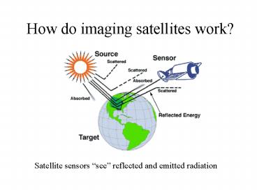
How do imaging satellites work?
How do imaging satellites work – PowerPoint PPT presentation
Title: How do imaging satellites work?
1
How do imaging satellites work?
Satellite sensors see reflected and emitted
radiation
2
(No Transcript)
3
Electromagnetic Spectrum
4
(No Transcript)
5
(No Transcript)
6
Successful Launch of Landsat-7April 15th, 1999
7
(No Transcript)
8
Sediment Transport to and within Lake Erie
9
July 1, 2000 Landsat 7 Image Real Color Band
Combination
The extent of the sediment plume is more visible
using this band combination
10
The Effects of Urban Sprawl in NW Ohio
11
Reduced to Urban/non-urban
1984
1990
1994
1999
12
Land-use Classification of Toledo
Katrina Schutte
13
Dry Period
Turbidity of water in the Ottawa River, July 2000
After Heavy Rain
14
(No Transcript)
15
- In Collaboration with
- Lucas Soil and Water
- Conservation District
- Nature Conservancy
16
Irwin Prairie
Irwin Prairie
17
(No Transcript)
18
(No Transcript)
19
(No Transcript)
20
(No Transcript)
21
Monroe Power Plant
Monroe
22
(No Transcript)
23
(No Transcript)
24
(No Transcript)
25
(No Transcript)
26
Comparison of Student Cloud Observations with
AVHRR Imagery December 12, 2000
Clear 25 50 75
100
27
Comparison of Student Observed Snow Depth with
AVHRR Imagery December 12, 2000.
28
Students can see their data from a map or a table
29
http//dmc.ohiolink.edu/GEO/LS7/
30
(No Transcript)
PowerShow.com is a leading presentation sharing website. It has millions of presentations already uploaded and available with 1,000s more being uploaded by its users every day. Whatever your area of interest, here you’ll be able to find and view presentations you’ll love and possibly download. And, best of all, it is completely free and easy to use.
You might even have a presentation you’d like to share with others. If so, just upload it to PowerShow.com. We’ll convert it to an HTML5 slideshow that includes all the media types you’ve already added: audio, video, music, pictures, animations and transition effects. Then you can share it with your target audience as well as PowerShow.com’s millions of monthly visitors. And, again, it’s all free.
About the Developers
PowerShow.com is brought to you by CrystalGraphics, the award-winning developer and market-leading publisher of rich-media enhancement products for presentations. Our product offerings include millions of PowerPoint templates, diagrams, animated 3D characters and more.


