
Ocean Surveying PowerPoint PPT Presentations
All Time
Recommended

Ocean surveying is one of the best ways that helps to determine underwater areas features. All the details, such as - water depth, topographic features, measurements of tides, etc., are entirely appropriately covered under Ocean Survey.
| PowerPoint PPT presentation | free to download
Ocean surveying is one of the best ways that helps to determine underwater areas features. All the details, such as - water depth, topographic features, measurements of tides, etc., are entirely appropriately covered under Ocean Survey.
| PowerPoint PPT presentation | free to download

However, a new horizon has appeared in the form of bathymetric survey drones, which promise to transform the way we explore and map ocean depths.
| PowerPoint PPT presentation | free to download

Find the Best Marine & Hydrographic Survey Equipment Suppliers in Dubai UAE? Contact Mer-subsea.com we provides the Best Environmental Equipment Suppliers, ROV tooling Suppliers, Marine Solutions, Seismic Solutions, Designed Solutions & Geotechnical Equipment Suppliers in Dubai UAE
| PowerPoint PPT presentation | free to download

Multibeam Echosounder Survey is our specialty at Yolax Infranergy. we provide all types of hydrographic survey to suit any project need, including multibeam bathymetry, side-scan sonar and subsea metrology. Our multibeam echosounder provides imaging and mapping capability of high resolution in deep/shallow water systems. multibeam echosounder transmit sound waves from directly beneath a ship's structure to deliver fan-molded inclusion of the ocean bottom. MBES has a more than one transducers that enable a substantial swath of area to be surveyed at once making studying a lot quicker and more accurate. For more Info - http://www.yolaxinfra.com/echosounder.php Email - info@yolaxinfra.com
| PowerPoint PPT presentation | free to download

National Ocean Service. National Geodetic Survey ... National Ocean Service. National Geodetic Survey. Each antenna type has a unique phase pattern ...
| PowerPoint PPT presentation | free to view

When it is time to order your ocean survey equipment, you can work with a rental company that operates on the shore. You do not need to order all your gear from some far-off company that you have never heard of. Plus, you can get custom recommendations from the equipment maker when you are preparing your boat. Contact the equipment designer that is close to your docks so that you can talk about the equipment you need to be successful.
| PowerPoint PPT presentation | free to download

The Alaska Ocean Observing System (AOOS) A Regional Coastal Observing System within the Integrated Ocean Observing System Molly McCammon, AOOS Executive Director
| PowerPoint PPT presentation | free to download

Monitoring Impacts of Climate Change ... ocean environment interacts with tuna biology, ... early warning system for pending large-scale changes in the ...
| PowerPoint PPT presentation | free to download

1. Impacts on Tuna. SEAPODYM model is a model of high spatial resolution, that may be suitable as a monitoring and forecasting tool. Can assimilate environmental ...
| PowerPoint PPT presentation | free to download

ocean biogeochemistry-climate feedbacks. Silicifiers. N2 fixers. DMS producers. Calcifiers ... time (y) TM3 atmospheric transport model. Atmospheric Inverse ...
| PowerPoint PPT presentation | free to view

Together with the World Weather Watch, Global Atmospheric Watch, ... Lack of synoptic measurements of physical, chemical & biological properties & processes ...
| PowerPoint PPT presentation | free to view

Lack of long term, high resolution time series ... One inventory per 10 years. Number of observatories, flux, and ocean transport stations ...
| PowerPoint PPT presentation | free to view

NOS DataExplorer Enterprise GIS Efforts within NOAA's Ocean Service Jason Marshall (PSGS) NOAA Coastal Services Center Kim Owens NOAA Ocean Service
| PowerPoint PPT presentation | free to view

Alaska Ocean Observing System AOOS A Regional Observing System within the Integrated Ocean Observing
| PowerPoint PPT presentation | free to view

Map temporal changes by time-series & decadal resurvey ... Property-Property correlations. Nov. 14th, 2005. Doney-Repeat Hydro/CO2. Deutsch et al. (2005) ...
| PowerPoint PPT presentation | free to view

Combined effects of Ocean acidification and ocean warming on the biochemical composition and breeding of economic fish from the East Sea of China
| PowerPoint PPT presentation | free to download

Opening the Coastal Ocean Black Box and the Advent of Coastal Ocean Observatories Oscar Schofield, S
| PowerPoint PPT presentation | free to download

The network is mature more than 1 site every 150km. Quality ... Problem lightning rod obstructs satellites. Antennas on towers with guy wires poor stability ...
| PowerPoint PPT presentation | free to view

Massachusetts: Leading the Way on Ocean Management Assessment of Ocean and Coastal Economy in the Commonwealth of Massachusetts David Terkla University of ...
| PowerPoint PPT presentation | free to download

Alaska Ocean Observing System AOOS A Regional Observing System within the Integrated Ocean Observing
| PowerPoint PPT presentation | free to view

Ocean Dumping and the Antarctic: Tangled Legal Currents, Sea of Challenges Professor David L. VanderZwaag, Canada Research Chair in Ocean Law and Governance
| PowerPoint PPT presentation | free to download

Title: No Slide Title Author: Christian P. Sarason Last modified by: Christian P. Sarason Created Date: 5/10/2001 5:41:03 PM Document presentation format
| PowerPoint PPT presentation | free to download

Ocean Dumping and the Antarctic: Tangled Legal Currents, Sea of Challenges Professor David L. VanderZwaag, Canada Research Chair in Ocean Law and Governance
| PowerPoint PPT presentation | free to download

B - Proposals for an enhanced European ocean research fleet and its management ... and equipment time to be published. Reinforcement of the OFEG organisation ...
| PowerPoint PPT presentation | free to view

Margin of error of plus or minus 4.7 percent. Surveyed Businesses: ... Fifty-one percent reported fewer than ten employees. Survey: Sales / Revenue Growth ...
| PowerPoint PPT presentation | free to view

NOAAPMEL Hydrothermal Vents Program Presented by Dr' Joseph Resing Joint Institute for the Study of
| PowerPoint PPT presentation | free to view

Sector programs in Fisheries, Food & Farm, First Nations, Forestry; ... Fishery prosecuted with trawl and fixed gear; ... Fishing gear impacts sensitive marine ...
| PowerPoint PPT presentation | free to view

Oceanic Imaging Consultants, Inc. Software Services Systems Professional seafloor mapping software, created by surveyors, for surveyors
| PowerPoint PPT presentation | free to download
We are the best hydraulic survey company that estimates the water depth of the onshore or offshore marine environments that include waterway planning, dredging analysis, and wreck location.
| PowerPoint PPT presentation | free to download

Terrestrial surveying is one of the most commonly used service that includes terrestrial scanning in which tripod-mounted or ground-based light radar is used to create a high-resolution 3D image of objects and surfaces.
| PowerPoint PPT presentation | free to download
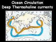
Ocean Circulation Deep Thermohaline currents Ocean Circulation Surface Circulation Wind Driven Ekman Transport and Geostrophic Currents Surface layer and Picnocline ...
| PowerPoint PPT presentation | free to download
An underwater survey looks at a variety of features. It is sometimes referred to as underwater surveying. Topographic characteristics, sea depths, and tide data are being studied and investigated. For a variety of practical reasons, knowing and understanding the curves and heights of ocean beds is essential. Bathymetric surveys are another name for hydrographic survey services. For more information about our Hydrographic Survey please visit : https://www.falconsurveyme.com/our-services/bathymetric-survey/hydrographic-survey-2/
| PowerPoint PPT presentation | free to download

Title: Intro Stream Processes Author: Greg Jennings Last modified by: CharlesPalmer Created Date: 12/5/2000 2:24:34 PM Document presentation format
| PowerPoint PPT presentation | free to view
Wave easy rolled over fore-deck covering it with more than 2 m water layer... transforms to solitons and breathers. Integrable model. coordinate. time. kA ...
| PowerPoint PPT presentation | free to download

Earth s magnetism Gravity Seismic vibrations / Vibrations of the earth Types: ... but it uses hydrophones (marine version of the geophone) Define Geophysics.
| PowerPoint PPT presentation | free to download

had fun with both the PP quiz and the constructing of posters. ... C-MORE's microbe personality quiz http://cmore.soest.hawaii.edu/education/kidskorner/ur_q1.htm ...
| PowerPoint PPT presentation | free to view

The model contains a variable velocity field overlying a ... ASCII (for VSP) NORSAR-3D Work Flow. Surfaces. Properties. Build Model. Survey. Depth. Model ...
| PowerPoint PPT presentation | free to view

Bathymetric survey drones, also known as underwater drones, are becoming an increasingly popular tool for conducting surveys of the ocean floor. These drones come in a variety of different types, each with their own unique features and capabilities.
| PowerPoint PPT presentation | free to download

invertebrate survey lab spring 09 ...
| PowerPoint PPT presentation | free to download

Ocean Observing Systems
| PowerPoint PPT presentation | free to download

61 Academic Institutions that use and/or operate oceanographic research vessels ... fully equipped machine shop, fume hoods, underwater bow observation chamber, un ...
| PowerPoint PPT presentation | free to view

Civil Engineering Surveying Prepaid by: 140670106083 140670106002
| PowerPoint PPT presentation | free to view

The oceans contain 97% of the earth's water. ... Whales , seals , dolphins, squid octopuses, barracuda and other fish are all nekton. ...
| PowerPoint PPT presentation | free to view
Ocean Commission Update Coastal and Ocean Governance Review for Washington State Presentation to Washington State Senate Committee on Natural Resources, Ocean and ...
| PowerPoint PPT presentation | free to download

A detailed description of each of the tests including; how they ... The measure and control of water hardness is essential to prevent clogging in water pipes. ...
| PowerPoint PPT presentation | free to view

Civil Engineering. Surveying. Roy Frank. Planning A Survey ... Based on American Society of Civil Engineering, Surveying, and Mapping Division. Design Maps: ...
| PowerPoint PPT presentation | free to view

If you’ve been searching for land surveyors in Dubai, this article will help you get all necessary and significant information need. With this blog, you will come to know everything about land survey easily.
| PowerPoint PPT presentation | free to download

The Ocean Observatories
| PowerPoint PPT presentation | free to view

Introduction Ocean Rise This case study guides you step by step through the design of a scenario workshop on local management of ocean rise and flooding for local actors.
| PowerPoint PPT presentation | free to download

Careers In Ocean Engineering
| PowerPoint PPT presentation | free to download

The valley ranges from 15 to 30 miles in width and contains an active seismic ... to fill depressions of the rocky ocean floor remains of marine life ...
| PowerPoint PPT presentation | free to view

Indian Ocean Tsunami. Boxing Day 2004 insert name here Lesson Aims. The aim of this lesson is for you to produce a PowerPoint presentation of the Asian Tsunami. ...
| PowerPoint PPT presentation | free to view

NASA's Earth Observing System Data and Information System provides ... Sea Surface Temperature, Ocean Winds, Circulation and Currents, Topography and Gravity ...
| PowerPoint PPT presentation | free to download

Modern Surveying equipment: Total Station * * Abhilasha P S, VAST THE TOTAL STATION K. Dennison * THE TOTAL STATION K. Dennison * Angular units can be decimal degrees ...
| PowerPoint PPT presentation | free to view