Demonstration Overview - PowerPoint PPT Presentation
1 / 7
Title:
Demonstration Overview
Description:
It is understood that this would not be the case in real world operations. ... UAV flies over target area and sends real-time situation awareness on the ... – PowerPoint PPT presentation
Number of Views:43
Avg rating:3.0/5.0
Title: Demonstration Overview
1
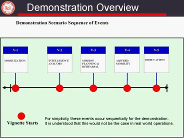
Demonstration Overview
For simplicity, these events occur sequentially
for the demonstration. It is understood that this
would not be the case in real world operations.
2
Mobilization (Vignette 1)
Today, large amounts of useful information are
being collected on the battlefield, but soldiers
are not aware of it nor are they able to locate,
access or visualize
3ID Force Replacement of 1st Cav
UTP
TEC (AGKC)
3
3ID Terrain Team
2
3
4
Enterprise GeoDB
1
Discovery Service
Topographic Analyst
Enterprise GeoDB
DTSS Map Service
Seamless discovery of, access to, and
visualization of geospatial information across
the enterprise eliminates duplicative IPB efforts
3
Intelligence Gathering (Vignette 2)
Geospatial information is a key component of
intelligence that is not being fully exploited
Visual geospatial information enhances actionable
intelligence
4
Mission Planning (Vignette 3)
Stovepiped systems and proprietary data formats
inhibit interoperability
Battalion Task Force
Brigade Combat Team
Joint Task Force
4
Local GeoDB
Enterprise GeoDB
Enterprise GeoDB
2
5
1
Movement Projection Service
Synchronization Service
3
3D Visualization Service
2
Enterprise Geospatial Services enhance
collaborative planning and interoperability
5
Assured Mobility (Vignette 4)
Soldiers currently do not receive timely
geospatial information
Joint Task Force
CAT-A Team
BuckEye
1
Detect Suspected IED
4
Brigade Combat Team
Bridge Destroyed
IED
2
Synchronization Service
Enterprise GeoDB
Intel Analyst
Movement Projection Service
3
Battalion Task Force
IED
6
5
Dismounted Soldiers as Sensors
Geospatial data collected and shared in near
real-time improves situation understanding
6
Direct Action (Vignette 5)
Soldiers lack the ability to obtain the latest
intelligence once the mission begins
TUAV tasked by BCT
New plan
Team
Team Leader
- UAV flies over target area and sends real-time
situation awareness on the objective to team lead - Team lead identifies building adjacent to
suspected hideout as the correct target - Team lead repositions entry team to enter
adjacent building and disseminates new positions
to the team
Sharing real-time situation awareness at the edge
improves mission effectivity
7
Demonstration Summary
- Discover data and services
- Enabled the analyst to find relevant data across
echelons to develop the operational picture and
improve situation awareness - Temporal and geospatial information intensifies
intelligence - Tracking services help visualize events spatially
- Geospatial data synchronization
- Enabled the commander to see near real-time
geospatial planning and operational updates to
improve his understanding of the battlespace - Soldier as sensor, information from/to the edge
- Integrate timely, local knowledge into common
operational picture - Geospatial analytical services at the platform
level - Enabled the commander to make decisions regarding
the safety of his troops in near real-time
1
2
3
5
4


